All Activity
- Past hour
-
Records: Highs: EWR: 98 (2012) NYC: 98 (1923) LGA: 98 (2012) JFK: 94 (2012) Lows: EWR: 52 (1956) NYC: 49 (1914) LGA: 55 (1959) JFK: 55 (2005) Historical: 1682 - A major tornado ripped through southwestern Connecticut, passing through Stratford, Milford, and New Haven, and then into Long Island Sound. (Sandra and TI Richard Sanders - 1987) 1921 - Circle, MT, received 11.5 inches of rain in 24 hours, a record for the state. The town of Circle received a total of 16.79 inches of rain that month to establish a rainfall record for any town in Montana for any month of the year. (The Weather Channel) 1928 - A farmer near Greensburg, KS, looked up into the heart of a tornado. He described its walls as rotating clouds lit with constant flashes of lightning and a strong gassy odor with a screaming, hissing sound . (The Weather Channel) 1956: A microburst caused a brief wind gust to 58 mph at Stapleton Airport. (Ref. Denver, CO Weather History) 1964 - A squall line producing large hail swept through central Illinois. A second squall line moved through during the early morning hours of the 21st, and a third one moved through shortly after dawn. The series of hailstorms caused nine million dollars damage. Hailstones as large as grapefruit caused heavy damage to trees, utility lines, crops and buildings. The thunderstorms also produced as much as five inches of rain in an eight hour period. (David Ludlum) 1975: Atlantic Beach, NC -- A man was killed on the beach by lightning. Lakeland, Fla.--A 16-year-old boy was killed instantly and his 16-year-old companion was injured when lightning struck a power line adjacent to a tree house in which the boys were located. (Ref. Lightning-The Underrated Killer.pdf) (David Ludlum) 1987 - Thunderstorms prevailed east of the Rockies, producing severe weather in the Central High Plains Region. Thunderstorms spawned four tornadoes in Colorado, and produced wind gusts to 70 mph at Goodland, KS. (The National Weather Summary) (Storm Data) 1988 - Thirty-eight cities in the central U.S. reported record high temperatures for the date. Afternoon highs of 97 degrees at Flint, MI, and 104 degrees at Chicago, IL, equalled records for the month of June. Thunderstorms in North Dakota produced baseball size hail near Kief, and wind gusts to 100 mph near McGregor. (Storm Data) (The National Weather Summary) 1989 - An early morning thunderstorm produced wind gusts to 61 mph at Pierre, SD, and the hot thunderstorm winds raised the temperature from 86 degrees at midnight to 96 degrees by 1 AM, and 104 degrees by 2 AM. Butte, MT, and Yellowstone Park, WY, reported snow that afternoon. (The National Weather Summary) (Storm Data) 1989:A meteorological "hot flash" hit Pierre. Descending air from collapsing thunderstorms caused the temperature in Pierre to warm from 86 degrees at midnight to 96 at one a.m. and to 104 at 2 a.m. Pierre's record high for the date of 105 degrees in 1974. 2000: Barrow, Alaska: The town of Barrow on Alaska's North Slope experiences its first recorded thunderstorm which dropped 0.16 inches of rain in just a couple minutes. (Ref. WxDoctor) 2001: Large hail driven by strong thunderstorm winds raked Denver International and front-range airports. Wind gusting to 54 mph along with hail as large as 2 inches in diameter punched at least 14 thousand holes and cracks in the flat roofs of several buildings at Denver International Airport. Also, 93 planes and hundreds of cars were damaged. About 100 flights had to be canceled stranding 1500 travelers. The Airport was completely shut down for about 20 minutes. The storm also damaged ground avoidance radar used to track planes on the ground to prevent collisions. Damage was estimated at 10 million dollars not counting the cost to the 93 airliners. The storm moved south and struck Watkins Colorado with hail as large as 2 1/2 inches in diameter and winds gusting to 60 mph.
-

Central PA Summer 2026 Discussion/Obs Thread
canderson replied to Voyager's topic in Upstate New York/Pennsylvania
It is desperately needed -
71 / 50 gorgeous day out there. Weekend looks amazing. Low - mid 80s. Next shot at widespread rains/storms on Monday >0.75 - 2.00 inches - looking focussed northern areas. Once passed monday trough into the northeast through the 27th but overall near normal. Moderation warming by the close with next heat as ridge and heat expands beyond into the start of next month.
-

Junorch obs and discussion 2026
Damage In Tolland replied to Damage In Tolland's topic in New England
It’s there starting late month right thru the 4th. Huge ridging east coast -
If I’m taking the family on vacation in the summer I need sun and fun, not rain and domestics.
-
-
Beautiful start to the day. 57*. We COC
- Today
-
Looks like the drought north of us is about over while it gets worse and worse around here. All that will miss to the north. Book it.
-
Raked the yard two weeks ago after the storm blew through and I think there's more debris down now from the wind Thursday than there was after that storm.
-

2026-2027 Super El Nino
snowman19 replied to Stormchaserchuck1's topic in Weather Forecasting and Discussion
The EURO is getting more aggressive with the +IOD, now showing a strong positive event come September -
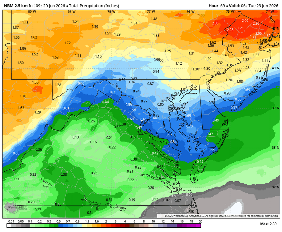
WB 9Z NBM for Monday.
-
Hrrrrr brings a chance for storms this evening. It definitely won't happen. If it does it's just going to hit Frederick lol
-
Call the ACO - maybe that official will trap out the dam builders.
-
Lots of hoodies this past work week. CON +0.8 and ORH +0.4 M-F. BOS +3.4
-

Central PA Summer 2026 Discussion/Obs Thread
mahantango#1 replied to Voyager's topic in Upstate New York/Pennsylvania
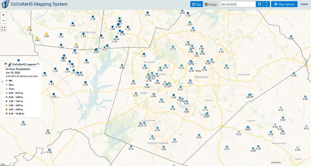
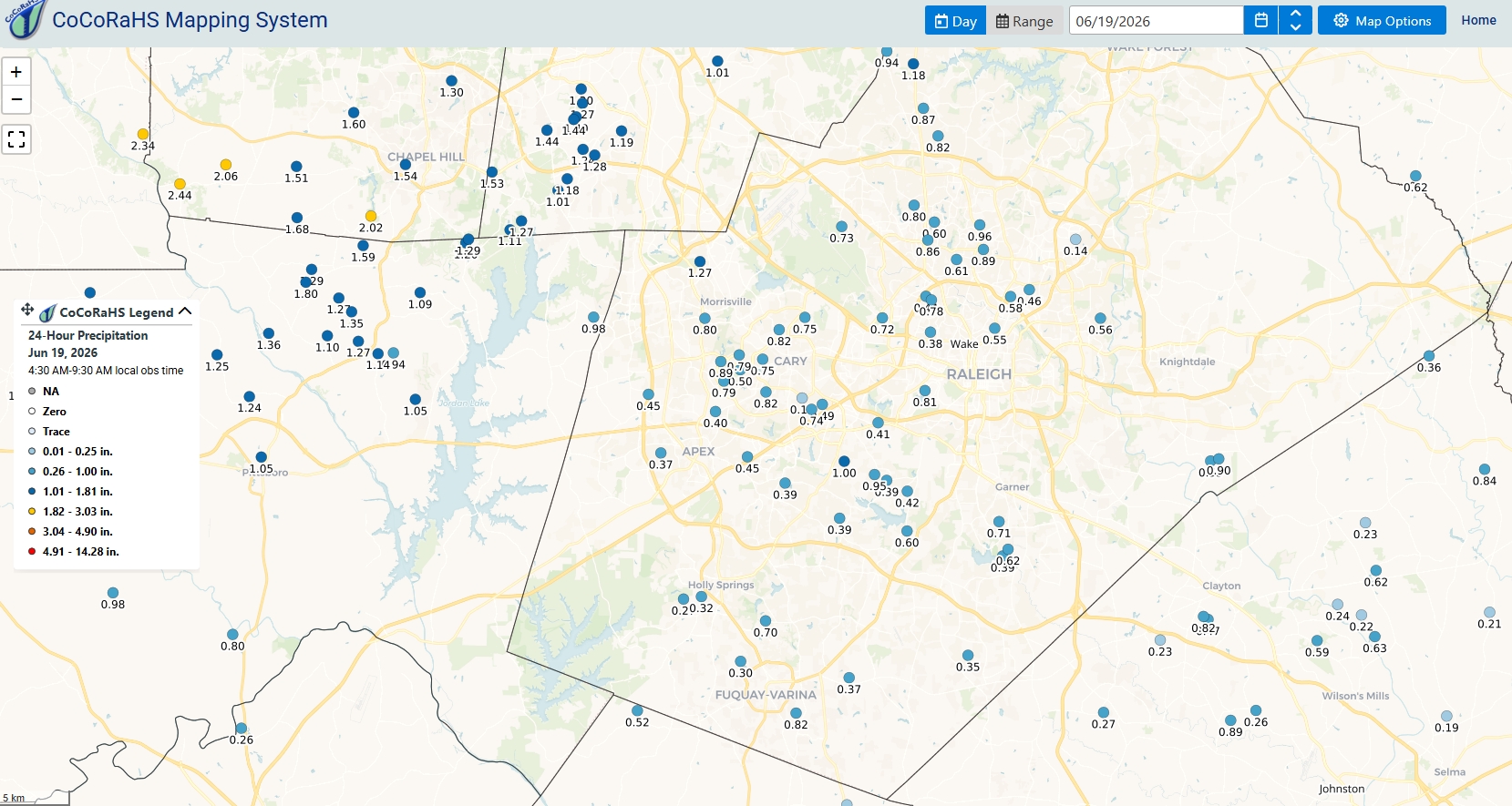
KEY MESSAGE 2: Widespread rain on Monday A wet start to the work week with widespread rain expected on Monday. The heaviest rainfall is most likely between 2AM and 8PM with totals in the 0.75-1.50" range. Current probs off the latest ensembles and National Blend indicate 50-80% probs for >1" across most of CPA. Flooding risk is marginal to low with greatest risk likely confined to urban areas where locally heavy or repeat downpours could cause some isolated runoff issues. Rain tapers off/ends Monday night with dry weather returning on Tuesday. -
Day 3 SPC OTLK for Monday... ...Carolinas to the Mid-Atlantic... A moist airmass will move into the Carolinas and Mid-Atlantic on Monday ahead of an eastward moving cold front. Mid-level lapse rates will be weak which will limit overall instability, but moderate shear and sufficient instability, combined with steep low-level lapse rates will support some damaging wind threat Monday afternoon/evening. In addition, a smaller area of greater low-level shear may exist closer to the surface low across northern Virginia and vicinity, which could have a localized region of greater tornado threat.
-
So you told no one Got it lol
-
Big heat is gone for awhile.. we tried to tell them
-

Central PA Summer 2026 Discussion/Obs Thread
pawatch replied to Voyager's topic in Upstate New York/Pennsylvania
50 degrees, nice morning Saw a deer, it was hustling through the backyard. Cardinal and hummingbirds at the feeders this morning. -
I was just STARTING to think that was it as well, but was not gonna buy into it until they got over .500. So often you see struggling teams can get on a random hot streak and pull within a couple games of that mark. But then just as they do they hit the wall, stupid stuff happens, and they fall backwards. The Blue Jays series was that moment: we win that we are just two games under with a chance to get to or over .500. But instead? We lost 4 in a row. It was that moment where I kinda closed the door on any chance of turning it around this year. They are somewhat better than last year, but still mediocre. And I do not think that's gonna change until they get rid of Elias. It's he and Sig that has made this system...and it has failed these players. I hope Rubenstein & Co. do the right thing!
-
lol let's go GGEM/RGEM for Monday!
-
Awful loss. But they've had a bunch of those already. Just no sign of them turning it around. I thought that 10 wins out of 14 games (or whatever that stretch was a couple weeks ago) was it...but nope.
-
I would not want to visit the Middle East. It is way too hot there. I have heard of their *LEGENDARY* heat indices over there. Make Texas in Summer look like a cool autumnal breeze lol.
-
MOAR storms are forming directly over Buda this morning at 12.47am!!! Some of the radar elements are deep red. This rain is torrential at times! We got three quarters of an inch in about 10 minutes! We are now up to 28.1 inches on the year! This is unbelievable! I am gonna have to start building Jebman's Ark!
-
We will see if Monday produces.


.thumb.gif.f92b16c631a1d15d405ed77b33f0710d.gif)


