All Activity
- Past hour
-
Fully selfish but in the past 5 I’ve had the microburst and the Arlington EF1 - which isn’t a terrible half decade. I guess general I’d say the storms feel a little wimpier, though.
-
0.38" so far with some rain still coming down. Enough to get us over 3" for the month now.
-
Over 0.5" in the 24 hours to 7AM... and a lot more to come after that. Looking forward to a green June
-
I don't disagree, but wow, that came out of left field.
-

2025-2026 ENSO
so_whats_happening replied to 40/70 Benchmark's topic in Weather Forecasting and Discussion
We had a strong/super El Nino just 2 years ago and wasn't able to break it. So what you would be suggesting is a higher than 2015/16 scenario given the WPAC has still warmed during that time frame which would mean an ONI above ~2.6C probably closer to 3C consistently over several months to reset the system? Honestly I feel that is not reasonable if 2 El Nino, as strong as what we have seen one being nearly the strongest we have physically recorded, can not cool the WPAC having a stronger one won't change that fact. I feel we need to give it time to see how this all plays out and feel it is too early to draw conclusions on something to say permanence has set in. Im not trying to play a gotcha moment if it does in fact change up over the next few years to decade or stays exactly the same. Would rather let it play out and get better understandings versus making such claims one way or the other. It would be awfully weird to make these claims that things have changed for the worst and then we get another 5-10 year block of crushing snows again. -
Been pretty uneventful for years it seems?
- 757 replies
-
- 1
-

-
- severe
- thunderstorms
- (and 2 more)
-
Yeah. Our region was in the light stuff most of the night. It started coming down harder around 3am here. I'm up to .87" so far and it's coming down pretty hard.
-

2025 Lawns & Gardens Thread. Making Lawns Great Again
Lava Rock replied to Damage In Tolland's topic in New England
Other than using black garbage bags to cover up and kill mugwort, which apparently can take up to a year, is my only option Roundup? -
Looks like installs finally happening this weekend.
-
Any updates ? Im counting down
-
It is 2025. Should we be using the most recent 30 year average temperatures from 1994 through 2024 instead of 1991-2020, if we are really concerned about comparing our daily averages to a "representative" trend? I sense many inconsistencies with not using the full history of data to calculate the daily average temperature instead of some "arbitrary" set of years. I mean, if you want to emphasize recent trends, why are you discounting the most recent 4 years?
-
39F for the low again and ready to launch another 40+ degrees.
-
Just the Tip
-
Fn... ALEET!
-
Still foggy with a heavy drizzle falling. 1.11 in gauge at 7 am reading, the 52.3 degree high held and set a record as I posted earlier. Currently 50.4/49.6. The 1.11 no where near a daily rainfall, that goes to the 2.27 that fell back in 1981.
-

Central PA Spring 2025
Itstrainingtime replied to canderson's topic in Upstate New York/Pennsylvania
Up at 2:15am to take our oldest son to PHL - nice soggy trip both ways. At least traffic wasn't bad at those hours. -
Kind of a sneaky warm one incoming today.
-
Emerging more prominently last night, that onshore tendency - EUro cuts off the trough under the ridge into the sotheast and gfs looks like the eps. We have seen this progression much of the last 5-7 years. Heat takes a week or so to get past inland areas. overall ridging and much warmer into the area.
-
Central PA Spring 2025
Itstrainingtime replied to canderson's topic in Upstate New York/Pennsylvania
I got up yesterday and saw that Elliott was predicting that rain would arrive in Lanco just after the evening commute. I had to do a double take to verify that he meant yesterday. At any rate, not sure what he saw but he said we'd be wet by 9pm. Rain started at my house at 8:45pm. -
Signs heat arrives by next weekend and not really leaving. Above normal temps for the summer it seems are likely.
-
58 / 53 cloudy light rain. Rain Wed - Sat totaling 1.00 - 2.40 in the highest locations with the heaviest in 2 timeframes today , break Thursday with mainly light rain and then Friday evening into Saturday with the heaviest portion. Clouds clear on Sunday. Warmth and heights rising into the east - still a tendency coming around to past June heat periods with onshore flow keeping the warmest - hottest west of the coast / inland starting on / around 6/5. Overall warmer with chance first chance of heat first inland then area into the second week 9th. Should also be drier but remain with rain chances from storms.
-
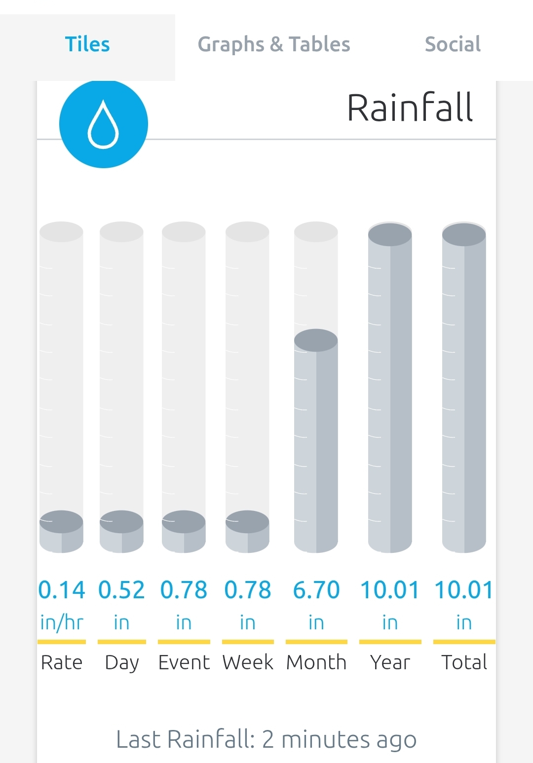
.92” as of 7AM. Well over 6 inches for the month and probably going to make a run at seven.
-

2025-2026 ENSO
40/70 Benchmark replied to 40/70 Benchmark's topic in Weather Forecasting and Discussion
I think within a few years a more moderate El Nino could suffice, somewhere in between those two extremes....I am sure CC is enhancing this pattern, but its not entirely unprecedented, as the potent 1972-1973 El Nino also featured a great deal of MC forcing due to the Pacific cold phase. That ended later in the decade with the Pacific phase flip and a couple of meager warm ENSO events. - Today
-
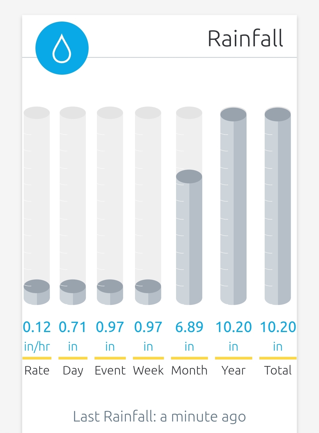
1.2" so far this event. Puts me over 10" for the month.