All Activity
- Past hour
-
Coastalwx?
-
My experience of many years in the foothills - early May storms excite me. But that is a foothills perspective and setups like this in May usually have a steep accumulation gradient. All or nothing usually within 10 miles.
-
coastal
-
May 2 2013: A historic snowstorm dumps up to 18 inches of snow in southeast Minnesota and west central Wisconsin. Blooming Prairie receives 18 inches from this storm, and Eau Claire gets 9.3 inches. For Saturday, May 2, 2026 1899 - A storm buried Havre, MT, under 24.8 inches of snow, an all-time record for that location. The water equivalent of 2.48 inches was a record 24 hour total for the month of May. (The Weather Channel) 1920 - A swarm of tornadoes in Rogers, Mayes and Cherokee Counties in Oklahoma killed 64 persons. (David Ludlum) 1929 - Virginia's worst tornado disaster occurred. Six tornadoes, two of which were west of the Blue Mountains, killed 22 people. Twelve children and a teacher were killed at Rye Cove, in Scott County. Four schools were destroyed by the storms. (The Weather Channel) 1983 - Severe thunderstorms spawned twenty tornadoes across Michigan, Ohio, Pennsylvania and New York State. The tornadoes caused five deaths. (The Weather Channel) 1987 - Thunderstorms in the Lower Mississippi Valley produced golf ball size hail in northern Louisiana, and wind gusts to 77 mph at Lake Providence LA. Thunderstorms in Arkansas produced 4.20 inches of rain at Arkadelphia and 4.00 inches at Bismarck. (Storm Data) (The National Weather Summary) 1988 - A powerful storm produced snow and high winds in the Central Rockies and the Central High Plains Region. Snowfall totals in Colorado ranged up to 12 inches at Strasburg, and winds in southeastern Colorado gusted to 87 mph at Lamar. Snow and high winds created blizzard conditions in eastern Colorado and southeastern Wyoming. (The National Weather Summary) (Storm Data) 1989 - Thunderstorms developing to the north of a warm front produced severe weather in Oklahoma and Texas. There were 93 reports of severe weather. Thunderstorm winds gusted to 80 mph at Beattie, and baseball size hail was reported at Ranger and Breckenridge. Juneau AK reported a record high temperature of 72 degrees while Honolulu equaled their record low for the month of May with a reading of 60 degrees. (The National Weather Summary) (Storm Data) 1990 - Fourteen cities in Florida, Georgia and South Carolina reported record high temperatures for the date as readings soared into the 90s. Tampa FL reported a record high of 97 degrees, and Fort Stewart GA was the hot spot in the nation with a reading of 100 degrees. 1990 - Thunderstorms produced severe weather from northeastern Texas to western Arkansas during the evening and early nighttime hours. Thunderstorms spawned a tornado which injured thirteen persons at Paris TX, and produced baseball size hail at Rio Vista TX. Thunderstorm rains of four to seven inches caused flash flooding in west central Arkansas, southern and eastern Oklahoma, and northern Texas. (The National Weather Summary) (Storm Data)
-

Central PA Spring 2026 Discussion/Obs Thread
Itstrainingtime replied to Voyager's topic in Upstate New York/Pennsylvania
Finished with .1" of rain overnight. -
A nice cold morning so far with a current temp of 46 degrees
-
Chilly morning with temps in the upper 10's/20's. Yesterday was a cool one in the lower 40's. Warmer today in the 50's/60's. Only for the weekend as temps head back into the 40's for next week.
-
Who looks at the gfs?
-
Zero coastals on the 6z gfs
-
Records: Highs: EWR: 92 (2001) NYC: 90 (2018) LGA: 90 (2018) JFK: 83 (2018) Lows: EWR: 35 (1943) NYC: 37 (1903) LGA: 40 (1978) JFK: 39 (1964) Historical: 1899 - A storm buried Havre, MT, under 24.8 inches of snow, an all-time record for that location. The water equivalent of 2.48 inches was a record 24 hour total for the month of May. (The Weather Channel) 1920 - A swarm of tornadoes in Rogers, Mayes and Cherokee Counties in Oklahoma killed 64 persons. (David Ludlum) 1929 - Virginia's worst tornado disaster occurred. Six tornadoes, two of which were west of the Blue Mountains, killed 22 people. Twelve children and a teacher were killed at Rye Cove, in Scott County. Four schools were destroyed by the storms. (The Weather Channel) 1935:Minneapolis, Minnesota on the 1st and 2nd: Snow, ice and sleet blanket parts of southeast Minnesota. Minneapolis receives 3 inches of snow. (Ref. WxDoctor) 1939: A trace of snow fell on this date in Raleigh, NC, their latest snow on record. (Ref. Wilson Wx. History) 1945: The record low temperature for the date at Washington, DC. is 35°F. (Ref. Washington Weather Records - KDCA) 1954: A major late season snowstorm struck the Arrowhead of Minnesota, leaving 18 inches of new snow at Virginia, Minnesota. (Ref. Wilson Wx. History) 1963: Record chill hit parts of North Carolina. Charlotte dropped to 32° and Greensboro & Raleigh fell to 29°; all records for May. (Ref. Wilson Wx. History) 1968: An extreme example of diurnal temperature fluctuation was reported at Juniper Lake in Oregon when the temperature purportedly rose from a morning low of zero to an afternoon high of 81°F. (Ref. Extreme Weather p. 47, by Christopher C. Burt) 1983: Severe thunderstorms spawned twenty tornadoes across Michigan, Ohio, Pennsylvania and New York State. The tornadoes caused five deaths. (Ref. The Weather Channel) 1983 - Severe thunderstorms spawned twenty tornadoes across Michigan, Ohio, Pennsylvania and New York State. The tornadoes caused five deaths. (The Weather Channel) 1987 - Thunderstorms in the Lower Mississippi Valley produced golf ball size hail in northern Louisiana, and wind gusts to 77 mph at Lake Providence LA. Thunderstorms in Arkansas produced 4.20 inches of rain at Arkadelphia and 4.00 inches at Bismarck. (Storm Data) (The National Weather Summary) 1988 - A powerful storm produced snow and high winds in the Central Rockies and the Central High Plains Region. Snowfall totals in Colorado ranged up to 12 inches at Strasburg, and winds in southeastern Colorado gusted to 87 mph at Lamar. Snow and high winds created blizzard conditions in eastern Colorado and southeastern Wyoming. (The National Weather Summary) (Storm Data) 1989 - Thunderstorms developing to the north of a warm front produced severe weather in Oklahoma and Texas. There were 93 reports of severe weather. Thunderstorm winds gusted to 80 mph at Beattie, and baseball size hail was reported at Ranger and Breckenridge. Juneau AK reported a record high temperature of 72 degrees while Honolulu equalled their record low for the month of May with a reading of 60 degrees. (The National Weather Summary) (Storm Data) 1990 - Fourteen cities in Florida, Georgia and South Carolina reported record high temperatures for the date as readings soared into the 90s. Tampa FL reported a record high of 97 degrees, and Fort Stewart GA was the hot spot in the nation with a reading of 100 degrees. 1990 - Thunderstorms produced severe weather from northeastern Texas to western Arkansas during the evening and early nighttime hours. Thunderstorms spawned a tornado which injured thirteen persons at Paris TX, and produced baseball size hail at Rio Vista TX. Thunderstorm rains of four to seven inches caused flash flooding in west central Arkansas, southern and eastern Oklahoma, and northern Texas. (The National Weather Summary) (Storm Data) 1999: A chilly start to May for the Sunshine State as more record lows fell by the wayside across Central and South Florida. Tampa dropped to 52°, St. Petersburg-Clearwater fell to 56°. Both these readings were all-time record lows for May. (Ref. Wilson Wx. History) 2002: A Roanoke, VA woman was injured by lightning while talking on the phone. (Ref. Lightning - Virginia Weather History) 2005: Late season snow blanketed the Texas Panhandle. Amarillo recorded 4.7 inches. (Ref. Wilson Wx. History)
-
61/41 mostly cloudy. Rain staying offshore. clouds today / clearing sunday and a 3-4 day moderation / warmup peaking on Tuesday with 80s in the warmest spots. Trough is back into the east with ride WC/P NW by later i the week 5/6 - 5/10 with next shot at rain Thu / Fri and >.50 possible. Overall near or below normal riding in that period beyond Tuesday to mid month.
- Today
-

2026-2027 Strong El Nino
MarcmmKU replied to Stormchaserchuck1's topic in Weather Forecasting and Discussion
Our variance is certainly very high.... Always makes the winter forecast a nail biter if you like snow lol -

Central PA Spring 2026 Discussion/Obs Thread
Jns2183 replied to Voyager's topic in Upstate New York/Pennsylvania
Hopefully they are properly hedged and insured. However, I'm sure those costs are through the roof Sent from my SM-S731U using Tapatalk -
Not enough cold, especially recently, but we will get the STJ and moisture. 'Perfect track rainstorms'. Need a -AO or -EPO to bring colder air southward. Recent Ninas have been cold mainly due to a favorable configuration(poleward) of the Aleutian ridge.
-
Man that is rough. Special prayers for her and you.
-
As a parent, your loving positive energy will ensure the best outcome. As always …..
-
and it has actually pushed a little more west to keep us in it.
-
Patchy Frost this AM. Beautiful spring day on tap
-
Yep, and if that marine layer ramps up it can take days to scour out.
-
Praying for continued recovery...
-
While it certainly won’t be the rain we were hoping for the cool steady rain is making for quite a pleasant morning here. It pushed just far enough west for Raleigh and the farm in Louisburg to get into the rain shield
-

Central PA Spring 2026 Discussion/Obs Thread
canderson replied to Voyager's topic in Upstate New York/Pennsylvania
.02” rain here. Day of garden work ahead. -
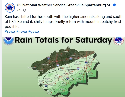
85 shift dance.
-
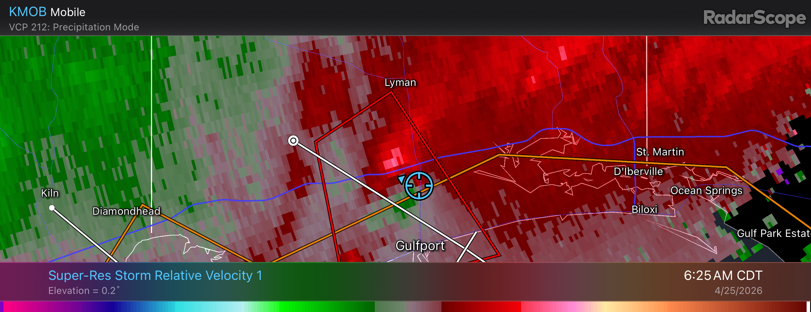
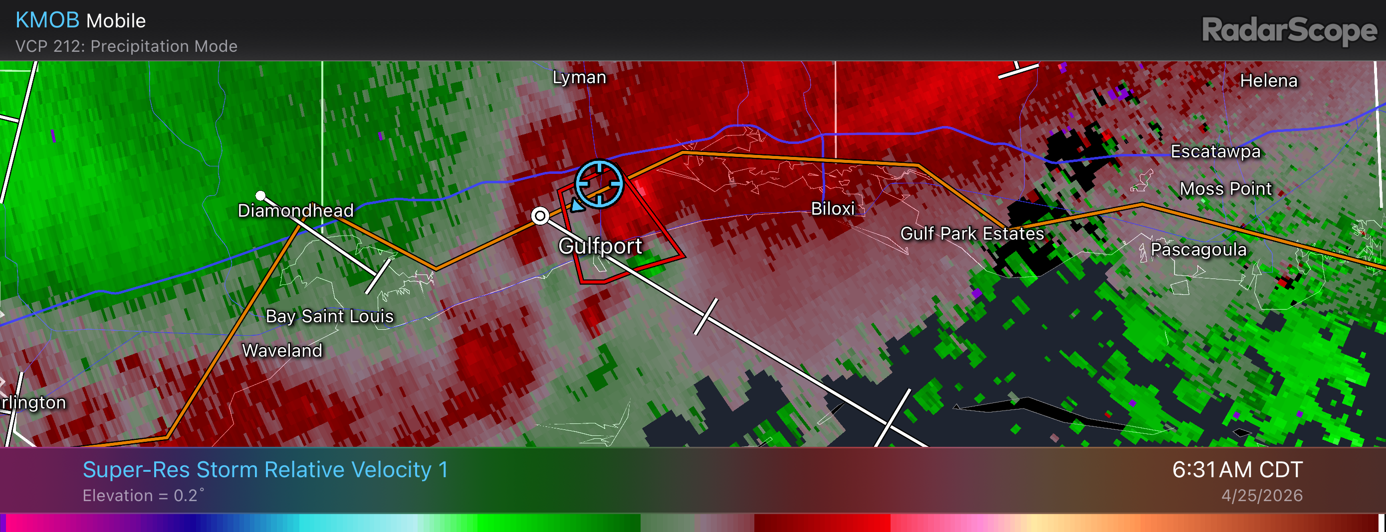
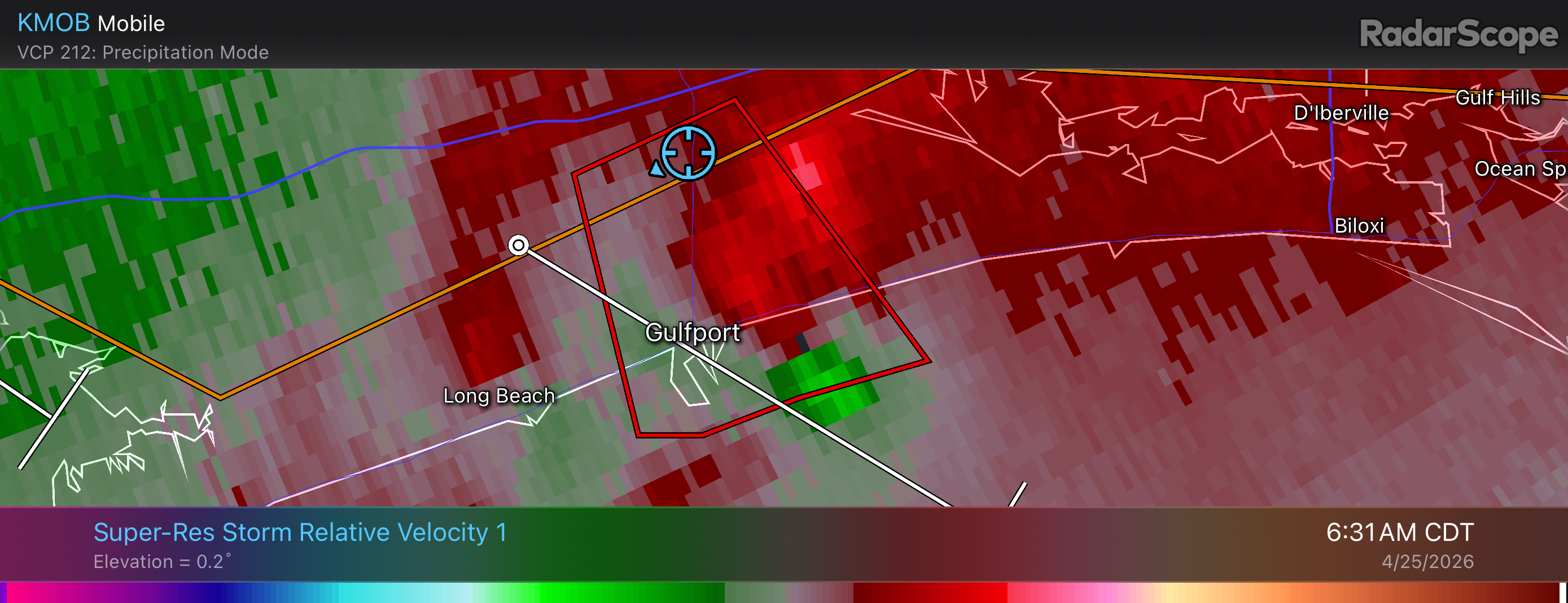
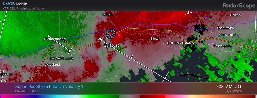
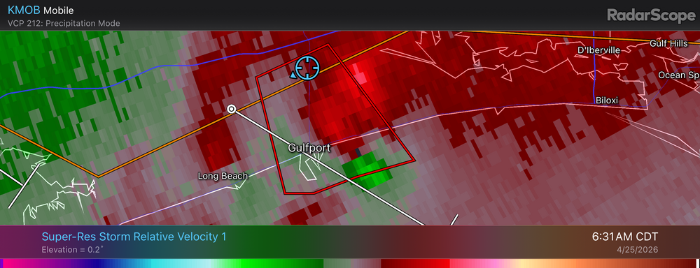
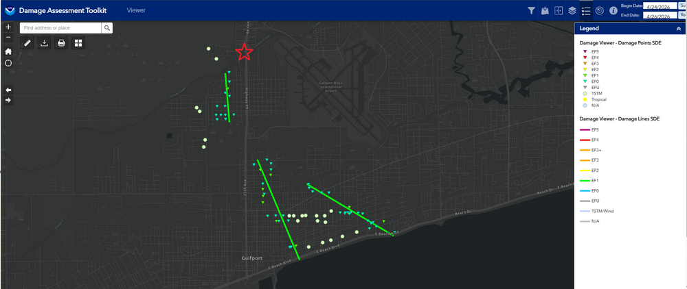
Gulfport Tornadoes 4-25-26 As @jaxjagman pointed out, there was a tornado that came within the vicinity of the JAN area on the 24th of this month, but I was out of town and was in no danger of being hit. However, that did not last very long as the QLCS pushed southward through the overnight hours into the early morning hours on the 25th of April, I had three different tornadoes that nearly hit me while I was out of town. Below are the radar images time stamped of the circulation along with my location as it went over my head. In addition, I am adding the NOAA/NWS Damage Toolkit to give context on how close the tornadoes came to hitting my hotel. There was damage with tree branches being snapped and even fences being damaged along HWY 90. I was not aware or saw any evidence of a tornado that touched down near HWY 49 earlier as there was little to know damage at my location outside of some power outages at some of the intersections with very minor tree damage. I was unable to get any pictures of any of the tornadoes as they were brief and heavily rain wrapped and could not be done safely. Disclaimer: The red star on the map is a rough estimate of where I was at in reference to the three tornadoes that had occurred the morning of April 25th, 2026. The radar imagery does contain the GPS location from RadarScope for supporting evidence as well.

-

Central PA Spring 2026 Discussion/Obs Thread
Mount Joy Snowman replied to Voyager's topic in Upstate New York/Pennsylvania
Low of 44 with .03” of rain. An epic sports lineup on tap today.


.thumb.gif.f92b16c631a1d15d405ed77b33f0710d.gif)


.thumb.jpg.049f4a7f726ada07e8cd30bd17e713cb.jpg)