All Activity
- Past hour
-
 Is it my imagination or does BOX update their forecasts less often than they did? Still a 7am discussion in there
 -
 You could consider checking out [url=https://retaildiscountprograms.online/#]visit the official website[/url] to understand how the process is handled.
 -

Central PA Summer 2026 Discussion/Obs Thread
Itstrainingtime replied to Voyager's topic in Upstate New York/Pennsylvania
-
Central PA Summer 2026 Discussion/Obs Thread
Itstrainingtime replied to Voyager's topic in Upstate New York/Pennsylvania
-
 An unseasonably strong shortwave trough amplifies as it swings across the Great Lakes region on Saturday as it advances towards the Northeast Saturday evening/overnight. As it does so, a cold front will push across the Great Lakes region during the day with a warm front lifting across the Northeast during the day on Saturday ushering in a warmer and more moist low-level airmass. Ahead of the trough features 40-45 knots of westerly mid-level flow with 30-40 knots of southwesterly flow in the lower-levels of the atmosphere which will contribute to 30-40+ knots of bulk shear, sufficient for storm organization. With the warm front approaching and a relatively uncapped airmass, extensive cloud cover along with scattered showers and thunderstorms are expected throughout the day and this does raise concerns about how much surface heating can occur and how much instability can build. Secondly, the timing of the rain and thunderstorms associated with a pre-frontal trough will be during the early evening, after peak heating. While instability would be a concern moving out of peak heating, as the warm front continues lifting through the region, the advection of higher theta-e air should help maintain what instability we have in place or even boost instability values a bit. CAMS are rather bullish in developing multiple rounds of thunderstorms across NY and PA with potential for multiple and concentrated swaths of damaging wind gusts and even potential for a few tornadoes given high helicity values. CAMS weaken this activity as it propagates across New England during the evening, however, given strong dynamics, increasing height falls, and at least weak instability (MLCAPE ~1000 JKG), localized damaging wind gusts and perhaps even an embedded tornado would remain possible as this activity crosses the region. As usual, the best potential for damaging winds or a tornado would be western sections. If instability turns out greater than forecast, there would be potential for a greater damaging wind threat across western MA and western CT.
 -
You could consider checking out [url=https://retaildiscountprograms.online/#]visit the official website[/url] to understand how the process is handled.
-
 Do they go down the aisle and select fatties?
 -
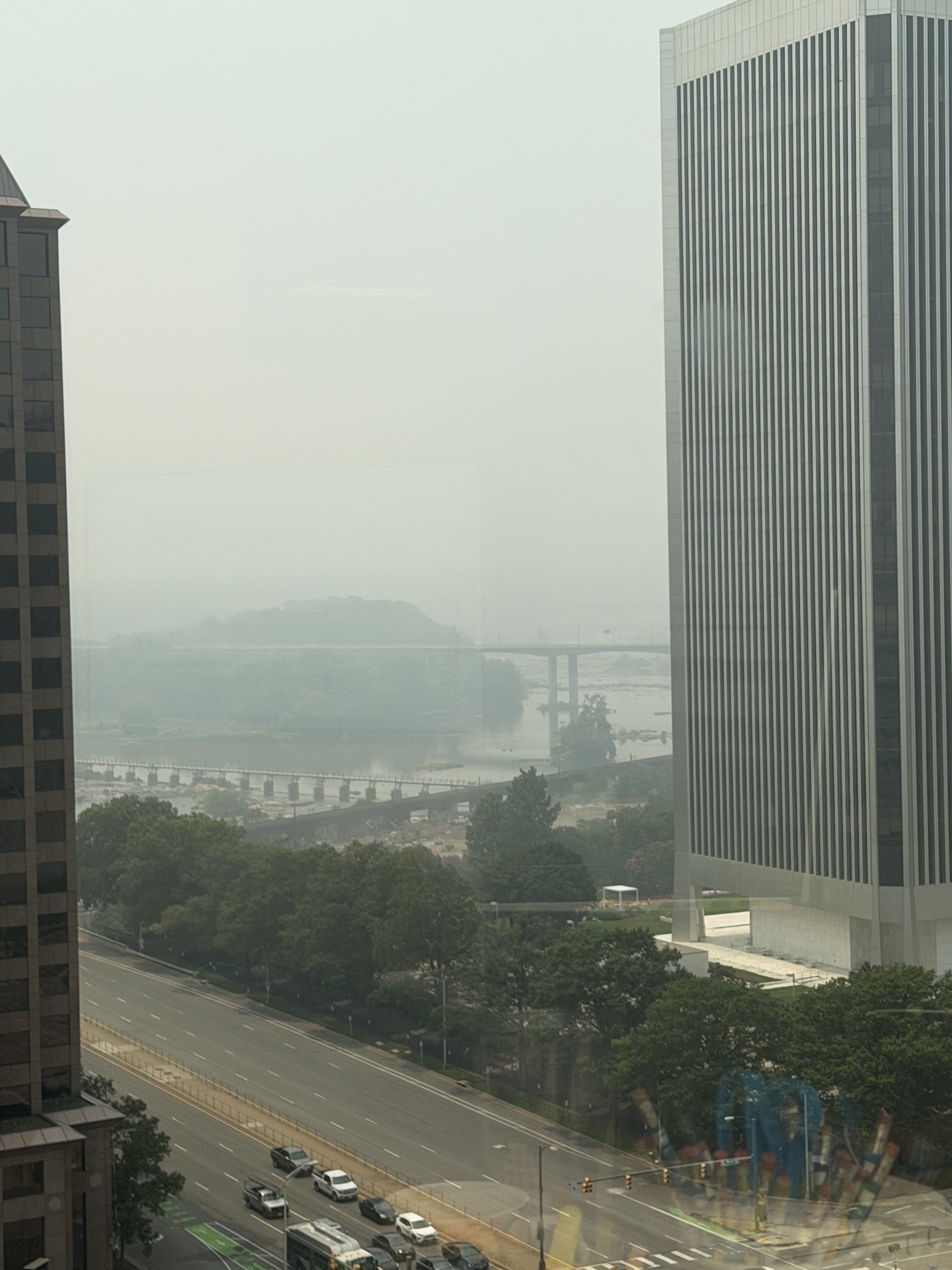
Need a big fat QLCS to blow and rain all the smoke out
- 1,034 replies
-
- 1
-

-
- severe
- thunderstorms
- (and 7 more)
-
@high risk @wxmeddler @Eskimo Joe Can smoke lay boundaries? I know Eskimo mentioned it in his post above... but is it something that we should be watching tomorrow morning? Also, doesn't the smoke act like a pseudo cap or EML in a sense in that it keeps the atmosphere from CI? Finally, wouldn't it also keep the moisture (dewpoints) up?
-
87 here much clearer as smoke south
-

E PA/NJ/DE Summer 2026 Obs/Discussion
Chadzachadam replied to PhiEaglesfan712's topic in Philadelphia Region
AQI is much lower than 2023 but the news said this was the first code purple since 2008, confusing. Even still, AQI of 265 imby is grounds for staying inside all day -
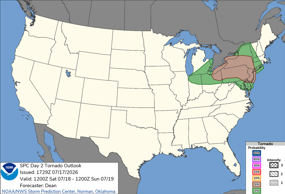
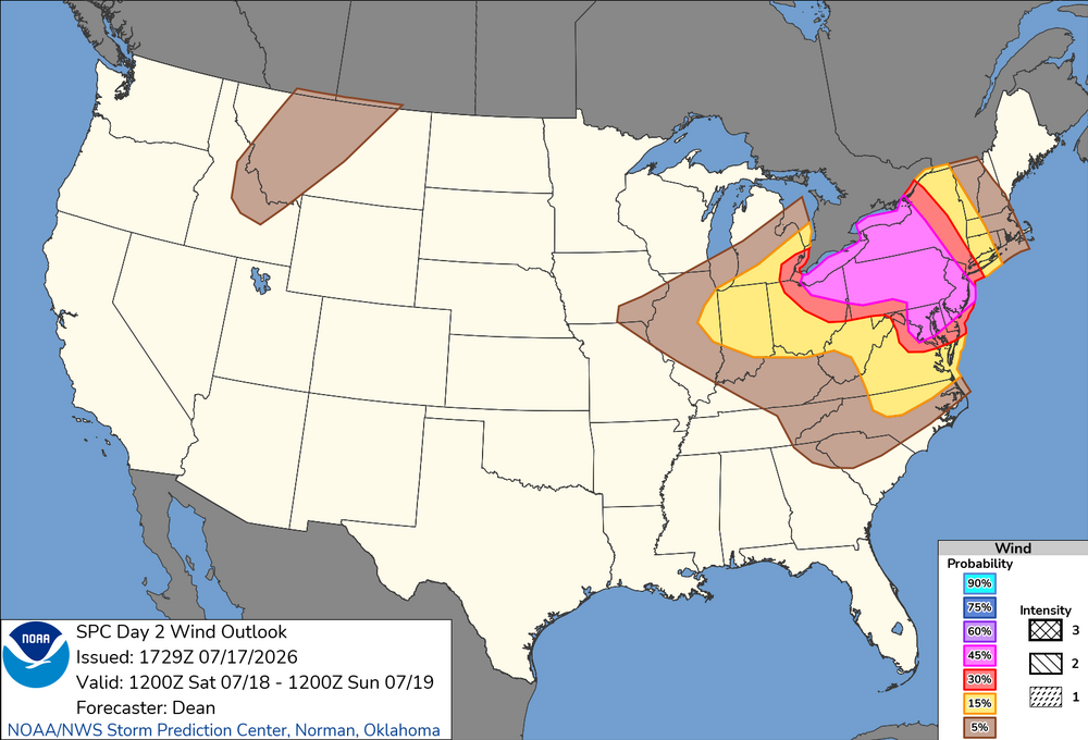
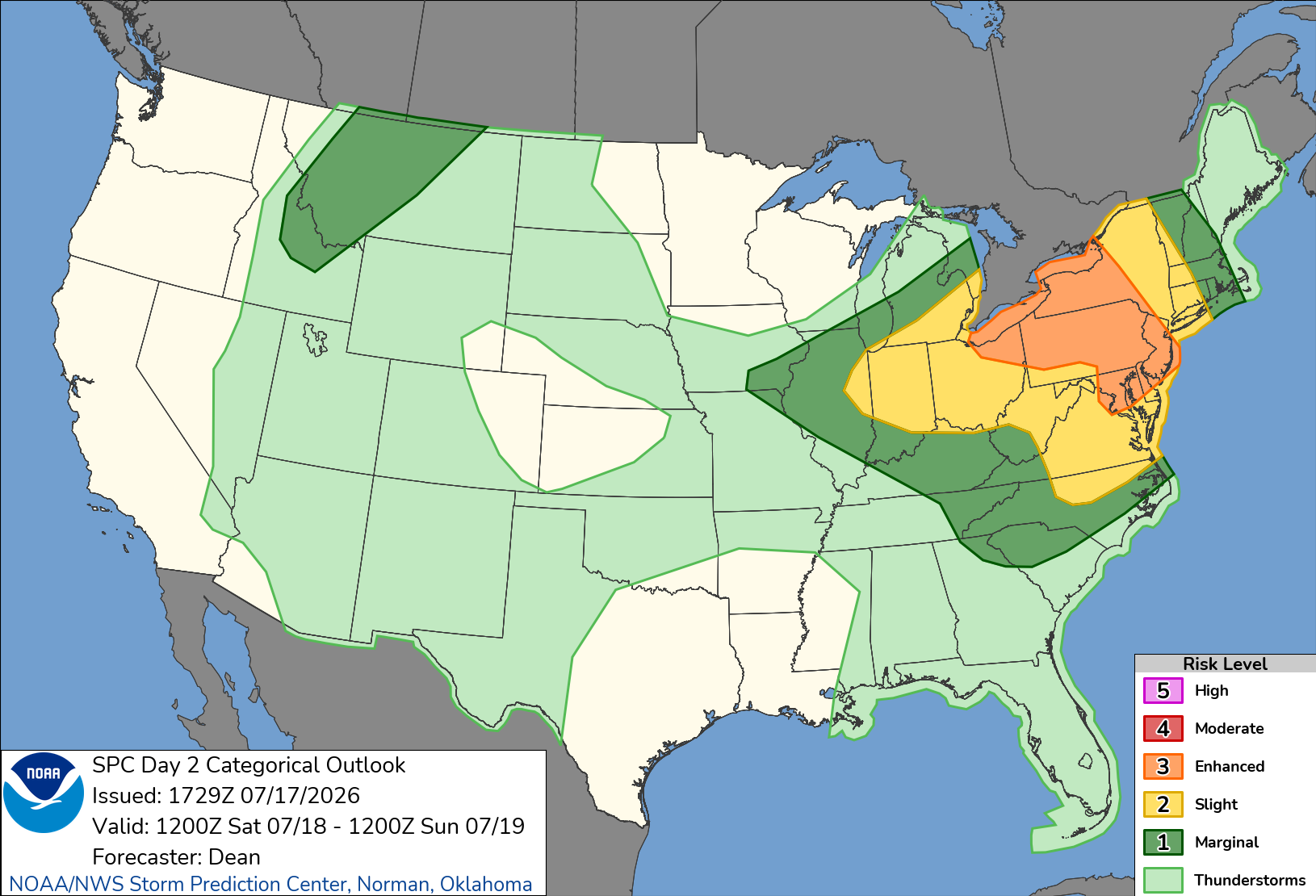
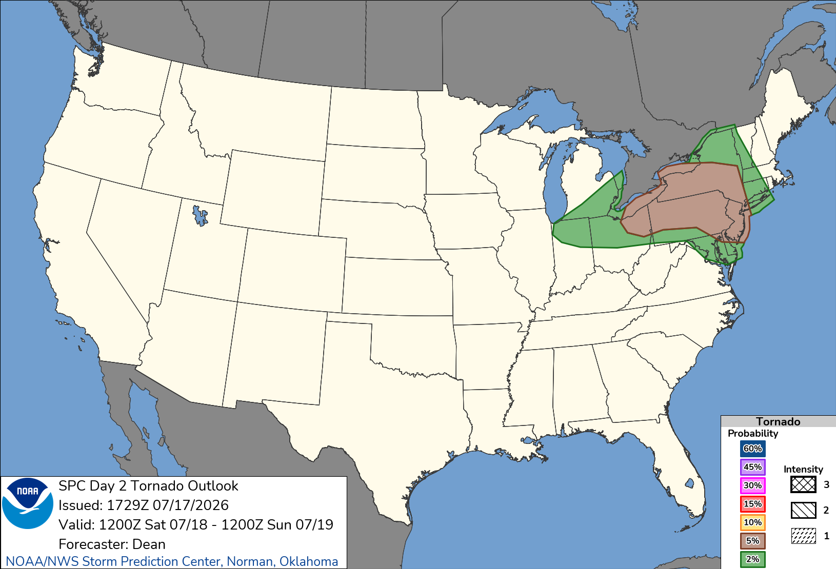
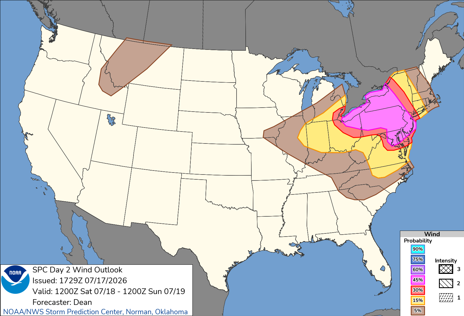
Day 2 Convective Outlook NWS Storm Prediction Center Norman OK 1229 PM CDT Fri Jul 17 2026 Valid 181200Z - 191200Z ...THERE IS AN ENHANCED RISK OF SEVERE THUNDERSTORMS FOR PARTS OF THE LOWER GREAT LAKES INTO THE MID-ATLANTIC... ...SUMMARY... Severe thunderstorms are expected across portions of the Ohio Valley and Lower Great Lakes into the Mid-Atlantic and Northeast, mainly Saturday afternoon into the evening. Some threat may linger into late Saturday night. ...Ohio Valley/Lower Great Lakes into the Mid-Atlantic/Northeast... An active severe-weather day is expected Saturday from parts of the Ohio Valley and Lower Great Lakes into the Mid-Atlantic, as scattered to widespread storms move through an increasingly favorable environment. A 45% wind area has been added, resulting in a categorical upgrade to Level-3/Enhanced Risk. The Enhanced Risk area is a combination of multiple regimes which may eventually overlap, with some areas potentially seeing multiple rounds of strong to severe storms. A mid/upper-level shortwave trough is forecast to move across the northern Great Lakes vicinity through the day, before approaching New England by evening. In conjunction with this shortwave trough, a deepening surface low is expected to move across southern Quebec toward northern Maine, as a trailing cold front moves through the Great Lakes and eventually parts of the Mid Atlantic and Northeast. A remnant surface front initially draped from southern NJ into western PA will lift northeastward as an effective warm front, in advance of the surface low and cold front. As strengthening deep-layer wind fields overspread increasingly rich moisture, a broad region from the Ohio Valley and Lower Great Lakes into the Mid-Atlantic and parts of the Northeast will become supportive of organized convection and severe-thunderstorm potential. HRRR-based forecasts suggest that smoke will become less prominent from west to east by afternoon, which should allow for relatively strong diurnal heating and moderate destabilization in areas not affected by early-day convection. Effective shear of 35-45 kt will support organized clusters and possibly occasional supercells from the Lower Great Lakes into the northern Mid-Atlantic and Northeast, while strong heating and steep low-level lapse rates will result in a favorable wind-damage environment within the somewhat weaker flow regime across the southern Mid-Atlantic and parts of the Carolinas. Elevated convection may be ongoing or else develop during the morning across parts of PA/NY, within a warm-advection regime associated with the returning warm front. Depending on the timing of this convection and downstream heating/destabilization, some intensification of ongoing convection may occur by early afternoon. Additional development may occur along the southwest flank of early-day convection and related outflow, which may intensify and move across the northern Mid-Atlantic during the afternoon. In addition to a wind-damage threat, some hail and tornado potential may also evolve with any supercell development, given the presence of favorable effective SRH. Farther north, a broken band of storms is expected to develop along the cold front and move across the Lower Great Lakes region, eventually reaching a larger part of OH/PA/NY by late afternoon or early evening. Additional storms may develop ahead of the frontal convection, depending on the extent of heating in the wake of early-day storms. Multiple wind-damage swaths may accompany this convection, along with some potential for isolated hail. Rich moisture and some enhancement to low-level SRH may also support a tornado threat with any discrete or embedded supercells, especially near the effective warm frontal zone or any remnant outflow boundaries from morning convection. An initially separate regime of storm development and severe potential is expected to develop along/east of a surface trough across parts of the southern Mid-Atlantic into NC. While deep-layer flow will tend to weaken with somewhat southward extent, strong heating and steepening of low-level lapse rates will provide a favorable thermodynamic environment for downbursts and damaging outflow winds. Depending on the extent of outflow from prefrontal storms, frontal convection may continue to pose at least an isolated severe threat through the evening as it spreads southeastward.
-
-
.thumb.gif.f92b16c631a1d15d405ed77b33f0710d.gif) Wednesday could be interesting timing-dependent and if we get some breaks
Wednesday could be interesting timing-dependent and if we get some breaks -
Much needed, decent coverage too.
-
ENH risk introduced on 1730z SPC OTLK
- 1,034 replies
-
- 1
-

-
- severe
- thunderstorms
- (and 7 more)
-

E PA/NJ/DE Summer 2026 Obs/Discussion
BBasile replied to PhiEaglesfan712's topic in Philadelphia Region
Enhanced for tomorrow.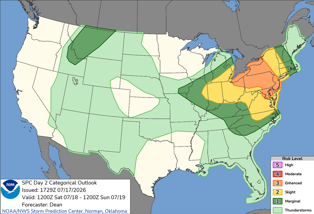
.thumb.png.a3493c024520326c9685b54ca963e7c3.png)
-
 Hot weather messing with lift. Needed 5 folks to give up their seats. Still had to burn fuel on tarmac before takeoff.
 -
Satellite and radar imagery definitely getting that "look" west of Florida with the MCV that is moving offshore. Mid-level rotation quite evident. NHC bumped odds up to 10/30 at 2PM. 12z Euro, GFS, Euro-AI all pinwheel this area of vorticity northward tomorrow up the West Coast of Florida
-
County cancelled some rec things but not adult softball, it’s play at your own risk. Sigh.
-
What about whole house battery back-up? @butterfish55 battery only installs a thing yet ? seems like if outages are short, battery tech might be far enough along to consider.
-
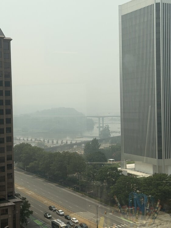
Probably does not do it justice. Why can’t Canada be burning some bacon or whiskey?
-
Lotta towers
-
Driving thru Frederick it looks worse than it did when I drove thru this morning.







.png.0c9e1e256d62e09ca8a67861b7f3f9e8.png)