All Activity
- Past hour
-
This was the 3rd warmest April on record for Long Island. Time Series Summary for ISLIP-LI MACARTHUR AP, NY - Month of Apr Click column heading to sort ascending, click again to sort descending. 1 2017 53.4 0 - 2010 53.4 0 2 2023 53.3 0 3 2025 52.8 0 4 2002 52.3 0 5 2012 52.2 0 6 1991 52.0 0 7 2019 51.9 0 8 1976 51.5 0 9 1974 51.4 0 10 2008 51.3 0
-
40F for the low, April to me flew by! Happy May Wiz hope you get your severe weather.
-

E PA/NJ/DE Spring 2025 Obs/Discussion
Albedoman replied to PhiEaglesfan712's topic in Philadelphia Region
OK Mt Holly, what do you guys have to say about this 40 degree diurnal temp change today? Woke up at 38 degrees this morning with a projected high of nearly 80 degrees? Wow have not seen this range in temps in a 12 hour time frame in a very long time on a nice day. Definitely living back in the CA Mojave desert environment in eastern PA from my younger days. -

E PA/NJ/DE Spring 2025 Obs/Discussion
PhiEaglesfan712 replied to PhiEaglesfan712's topic in Philadelphia Region
PHL finishes April with a 56.6 avg temp, which is 2.6 degrees above the 1981-2010 average. PHL is on track for a 5th straight spring with well above average temperatures. For the 2024-25 season, PHL finished with 8.1 inches of snow, which is the 7th time in 9 years (dating back to the 2016-17 season) that PHL finished with below average snowfall. 2017-18 is the only season in that timespan that had slightly above average snowfall, while 2020-21 had near average snowfall. -
Enjoy the sunshine today. Will be the last time we see it for 7 days
-

E PA/NJ/DE Spring 2025 Obs/Discussion
pl0k00n111 replied to PhiEaglesfan712's topic in Philadelphia Region
I am hoping the rain stops next Saturday, planning a outdoor party. -
2024-2025 La Nina
PhiEaglesfan712 replied to George001's topic in Weather Forecasting and Discussion
With April over, PHL officially finishes the 2024-25 season with 8.1 inches of snow. This is the 7th time in 9 seasons (dating back to 2016-17) that PHL has finished below average in snowfall. 2017-18 was the only season in that timespan that finished slightly above average in snowfall (and that was due to a record snowfall in March), while 2020-21 finished near average in snowfall. -
The Saturday after next looks pretty good.

-
Holy Shibt! That's a lot of rain potential. We could use it, or even half of it. The kids have field day tomorrow, hopefully the weather holds long enough to get that in. Sounds like it should.
-
kicking off the month with another soak, lots of flowers and the northside in full bloom right now
-
April AI vs. Actual Outcomes: AI showed a cool bias for the monthly mean temperatures. The extent of "skill" it has in monthly forecasts remains uncertain.

-
Yeah I wouldn’t call April nice. Had some warmth but a lot of winds, clouds, and days that never really materialized. An average April but not a nice April IMO . Still waiting for that really great spring stretch of weather
-
George BM I absolutely love your idea of severe weather! I really enjoyed this. Forecast Discussion SAT 31 MAY 2025 655pm EDT One of our senior forecasters, GBM, who has been with NWS for nearly twenty years, recently referred to our ongoing destructive wet weather this past month here in the greater Washington Metropolitan Region. Some communities have experienced upwards of 2 FEET of rainfall. We are not certain how this has happened, but Barry has explosively deepened into a strong Category Five hurricane with 195 mph winds. FL winds were reported by hurricane hunters, when converted to mph, as 237 miles per hour. This is a very serious situation. Barry has been buffeting the coastal Carolinas for the past two days as it moves slowly north. Modeling has indicated that the storm will interact with a trough which will pull Barry into the mouth of the Chesapeake Bay then catastrophically slow down in the Bay, possibly for 12 to 24 hours. Barry will probably cause generational impacts over the eastern Carolinas and Virginia over the upcoming 24 to 48 hours. Catastrophic Category Five wind gusts, extreme storm surge up the Bay, unbelievably strong battering waves on top of the surge as well as unprecedented amounts of rain will impact the entire region. Twenty to thirty feet of surge up the Bay with fifteen to twenty foot waves on top of the storm surge will produce extreme damage and severe beach erosion. Rain will be torrential, with rates of 2 to 4 inches at times within the stronger rainbands. Barry is a slow moving storm and is expected to possibly stall in the Bay. Evacuations are underway in Eastern Virginia. Everyone except for essential personnel are urged to leave the coastline and move as far inland as possible. It's not just extreme surge and waves and extremely high winds and freshwater flooding that are concerns with Hurricane Barry. It's tornadoes as well. Numerous tornadoes are expected over the Carolinas and Virginia. Further updates will be issued.
-
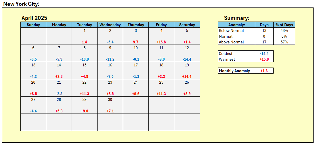
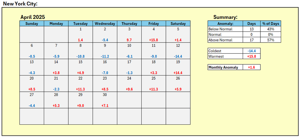
New York City's April Mean Temperature: 55.3° (1.6° above normal).
-
Down to 37F here in E CT.
- Today
-
HWO mentions the potential for flash flooding for the eastern WV panhandle this afternoon and evening.
- 1 reply
-
- 1
-

-
39.7° Not even close.
-
What is that? Assuming you meant Gulf of America
-
Another nice month? April was a washout. Even with a garbage blocking pattern taking place this weekend into next week....
-
Some last minute rain to close out the month with 0.02". Final total for the month is 6.15", still making it the 8th wettest April on record. Top 10 Wettest Aprils (DAY): 1. 9.20" - 1996 2. 8.72" - 2011 3. 6.95" - 1947 4. 6.78" - 1993 5. 6.52" - 1989 6. 6.32" - 1994 7. 6.19" - 1998 8. 6.15" - 2025 9. 5.98" - 1964 10. 5.87" - 1911 Cincinnati had an additional 0.18" to close out the month. Final total for the month is 7.47", making it their 5th wettest April on record. Top 5 Wettest Aprils (CVG): 1. 13.52" - 2011 2. 9.77" - 1998 3. 8.36" - 1947 4. 8.20" - 1996 5. 7.47" - 2025 I had a feeling that was coming all along thanks to the very wet start to the month.
-
 DCA _ NYC _ BOS __ ORD _ ATL _ IAH ___ DEN _ PHX _ SEA +1.4 +1.6 +1.7 +1.9 +.5 -.2 +1.5 +.3 +.5 Oh man almost forgot
 -
 +1.3 _ +1.4 _ +1.5 _ +1.2 _ +0.7 _ +0.5 _ +2.7 _ +1.0 _ +1.5
 -
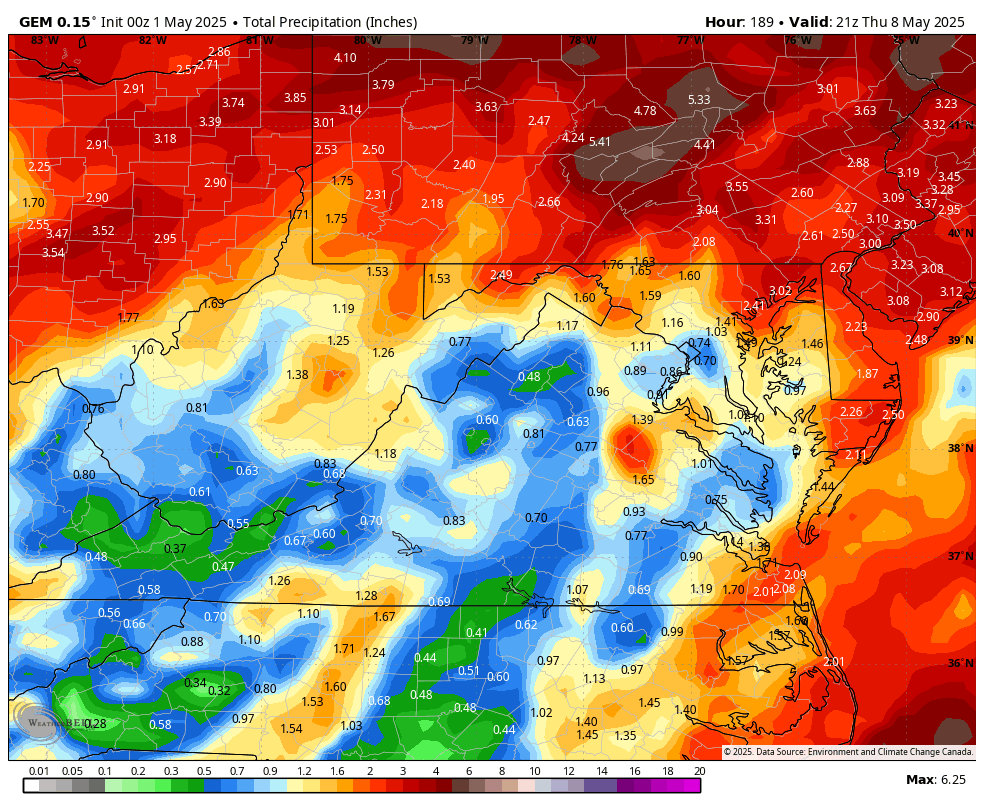
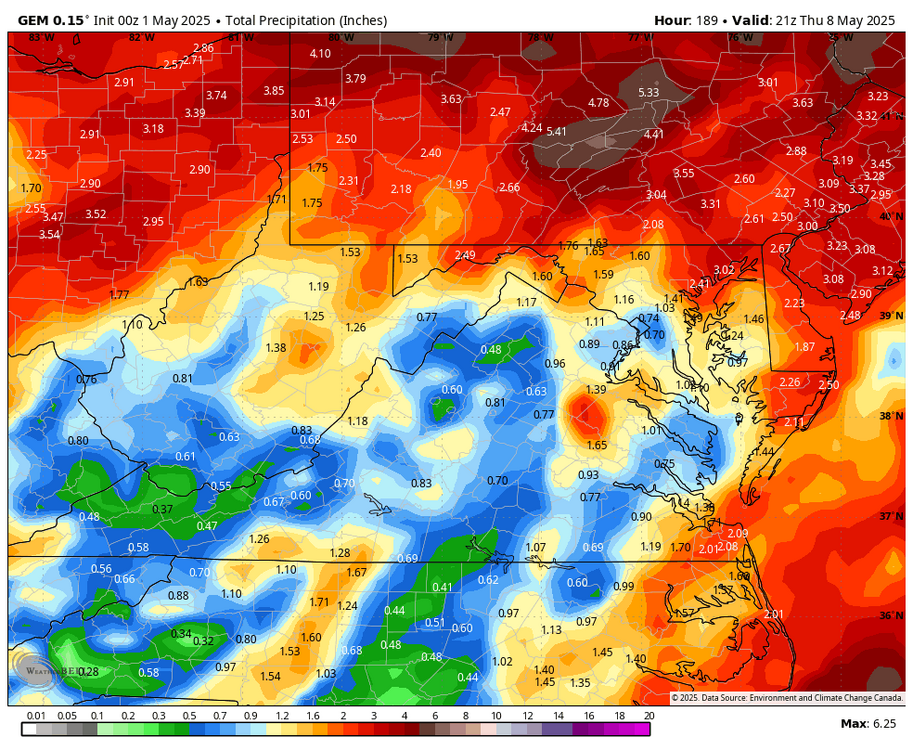
The 00z 5-1 GEM pushes the heavy rains north into Pennsylvania.
-
bring on the rain!
-
Precipitation is precipitation, winter or summer when looking 1 - 7 days into the future. The greater the expected sum total, the greater the error factor. The WPC has already changed significantly in the past 20 hrs. with qp amounts for the next 7 days.