All Activity
- Past hour
-

Central PA Winter 25/26 Discussion and Obs
Caveman replied to MAG5035's topic in Upstate New York/Pennsylvania
Interesting...even from a slide rule old fart! -
Yeah, which is definitely unfortunate. The good news is there’s at least some snow cover, and there won’t be much modification of the airmass due to the upstream snowpack combined with the winds/advection. This will be one of those arctic outbreaks where the airmass is very impressive (which I define as -35C or colder at H85 somewhere in the lower 48), but the ground temps underperform relatively speaking. Still impressive, but not what it could be. This is opposite of what occurred in January 2009, where the airmass wasn’t crazy cold but there were very low temps due to deep snowpack and clear/calm conditions. Regardless, we may see the coldest temp here since January 2019.
-

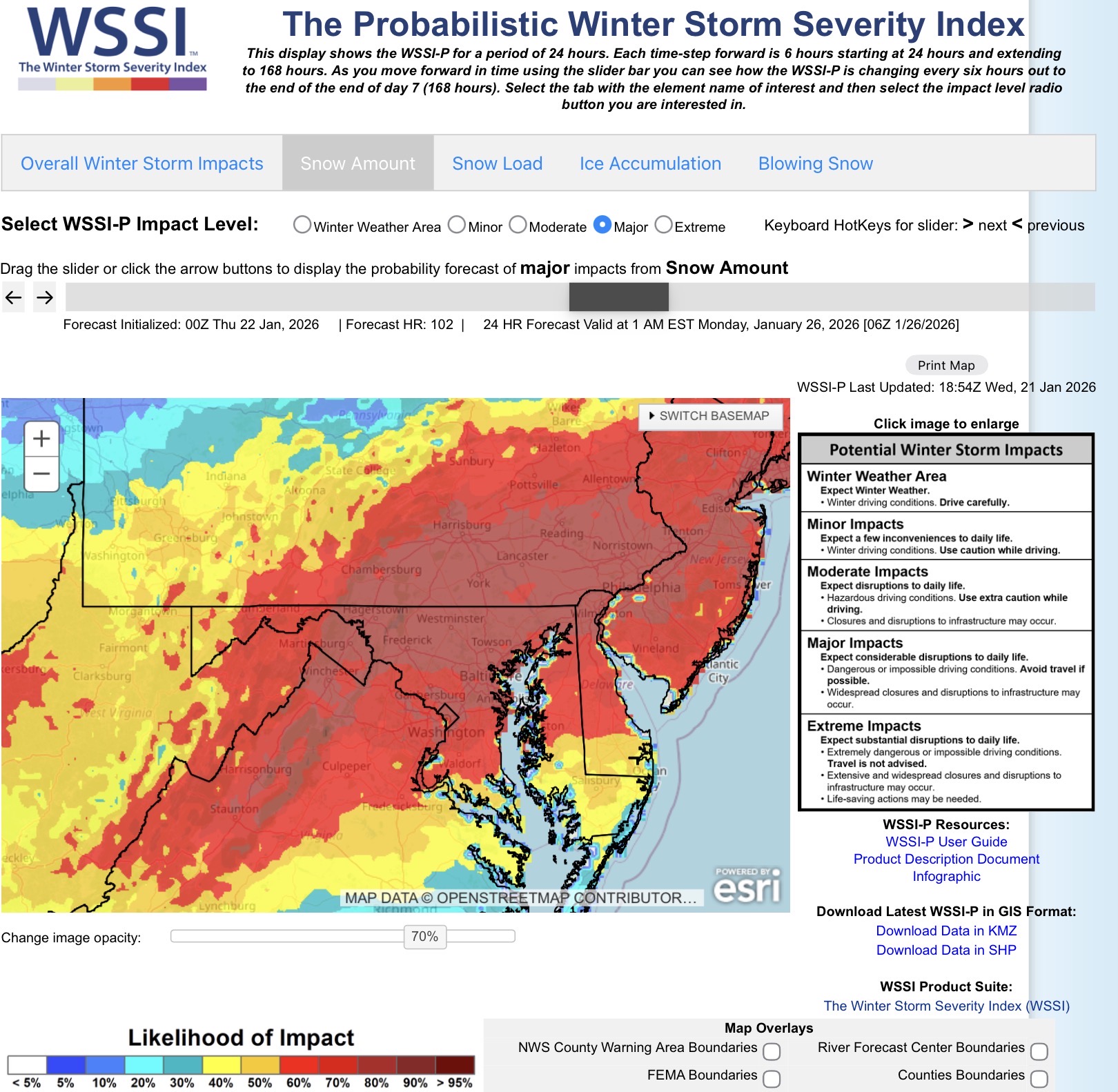
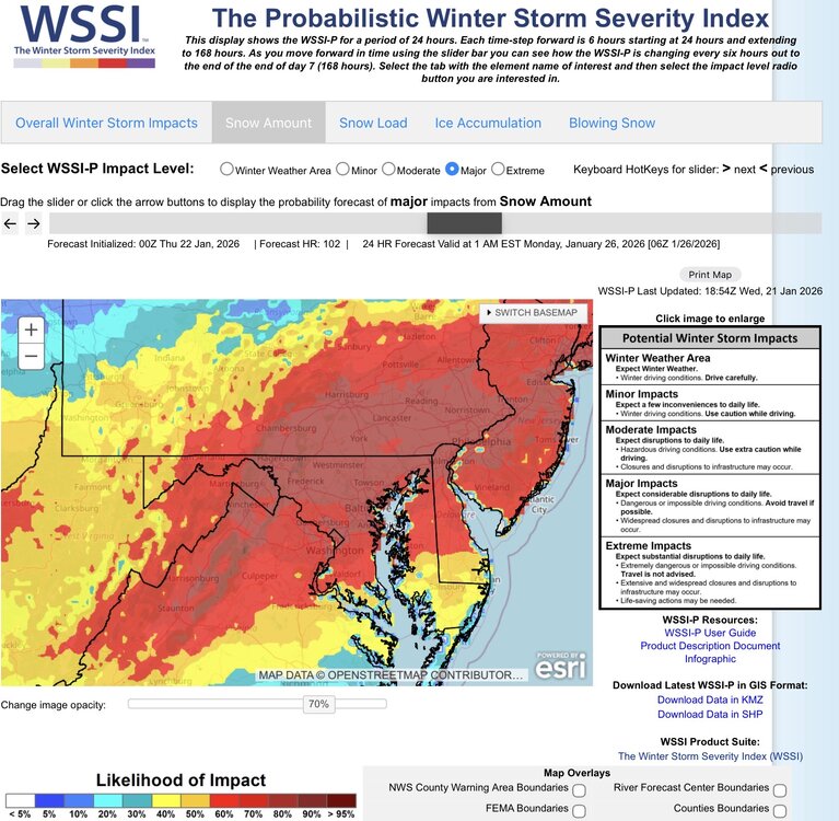
January 25-26 Winter Storm Potential
Albedoman replied to Ralph Wiggum's topic in Philadelphia Region
https://www.lehighvalleylive.com/weather/2024/02/lehigh-valley-weather-heavy-band-of-snow-dumps-foot-or-more-from-macungie-to-hellertown.html#:~:text=Lehigh Valley weather%3A Heavy band,more from Macungie to Hellertown&text=Snow falls in the Lehigh,Valley on Feb. 17%2C 2024. -

January 25-26 Winter Storm Potential
MacChump replied to Ralph Wiggum's topic in Philadelphia Region
love the enthusiasm, you'll balance out No Snow Flo and reestablish our equilibrium -

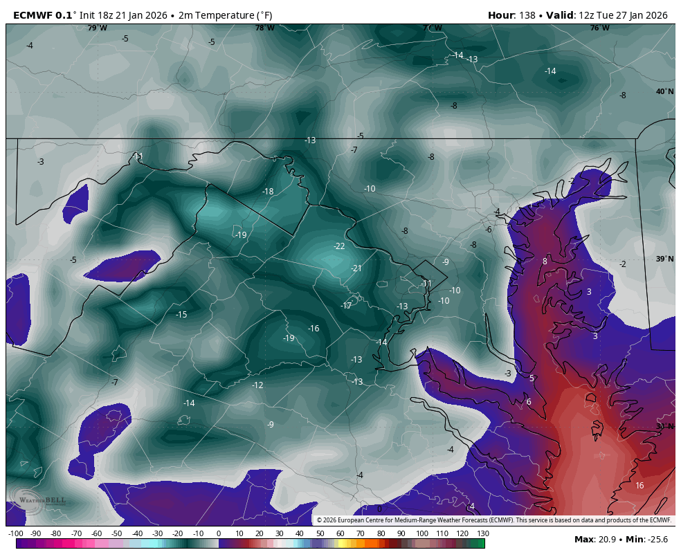
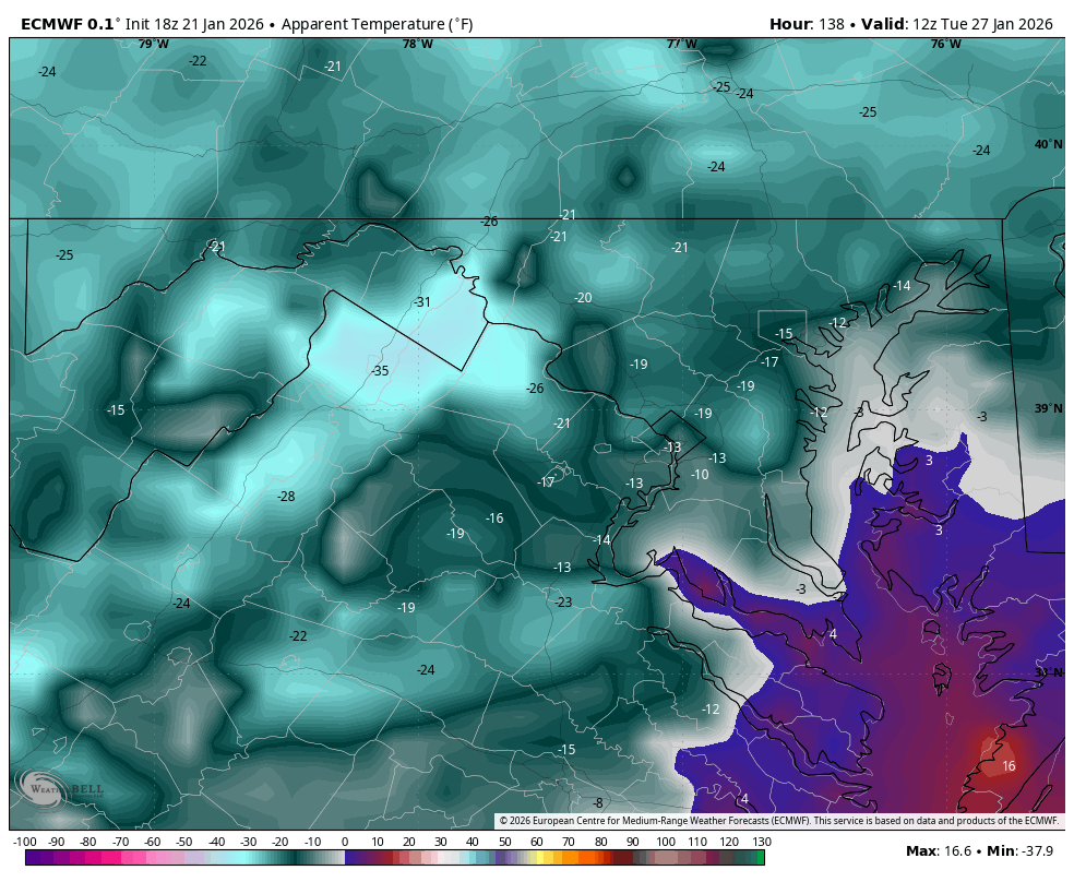
Possible Record Breaking Cold + Snow Sunday 1/25 - Tuesday 1/27
Jt17 replied to TriPol's topic in New York City Metro
Was it colder and snowier than Euro still? . -

January 25-26 Winter Storm Potential
penndotguy replied to Ralph Wiggum's topic in Philadelphia Region
I do kinda remember that, I lived in Barto it was ridiculous 02 maybe? -

1/23/26-1/25/26 Winter Storm Thread
Holston_River_Rambler replied to AMZ8990's topic in Tennessee Valley
I've wondered that too the past couple of days. -
On the fringe here. 0.25” or so.
-
-

January 24-26: Miracle or Mirage JV/Banter Thread!
ravensrule replied to SnowenOutThere's topic in Mid Atlantic
Who the frig has time to cook between work and model watching. Try some takeout. Taco Bell usually works wonders on my colon. -
I honestly wonder if the Canadians are cooperating with the Europeans on weather modeling and leaving us out in the proverbial cold.
-
As long as it doesn't last for 8 weeks straight.
-

Possible Record Breaking Cold + Snow Sunday 1/25 - Tuesday 1/27
NJwx85 replied to TriPol's topic in New York City Metro
My top 3 biggest heartbreaks are: 2/8/13 2/5/10 March 2001 Biggest Miracle: 12/26/10 Biggest storm missed while alive: PD2 - was in FL at Daytona 500. -
Sounds like Atl NWS isn’t buying the NW trends. https://x.com/justinwx02/status/2014108839042322785?s=10 .
-
Yep, not sure we should be celebrating or jumping off hypothetical bridges when we have this much run to run inconsistencies still. I've been telling stakeholders 12z Friday guidance is "lock-in" time since Monday AM. Patience.
-
Hopefully they are seeding it for a southern storm .
-
off to bed up at 245.. hopefully when I refresh this page there's tons of new post
-
just can't win for losing, we can't get a storm to phase and when they finally do it's a cutter
-
Haha- yes, not a thing, never has been, never will be....all models are showing 020-050 degree wind headings throughout the storm at CLT. They do not deviate much, if any, between models. NE wind = CAD from a 1040+ high over NY state throwing out dew points in NC/SC down in the teens...using this logic alone, if the low plowed through the wedge, the wind field would veer out to ENE or even south of 090.....then the CAD would become in-situ or not even present in the first place Also why they are looking at the actual metadata from the Baja low before buying into it. Metadata has already occurred, so it isn't influenced by any of the models. When the models begin to feed in the metadata, you will more than likely see several of them singing a different tune.... They obviously have some good forecasters over there who have a good handle on the potential flaws in the Euro- it takes a lot of experience to come to that conclusion after picking the ensembles apart
-

“Cory’s in LA! Let’s MECS!” Jan. 24-26 Disco
MaineJayhawk replied to TheSnowman's topic in New England
My cluster just tightened as well -
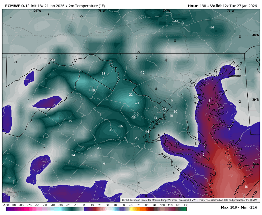
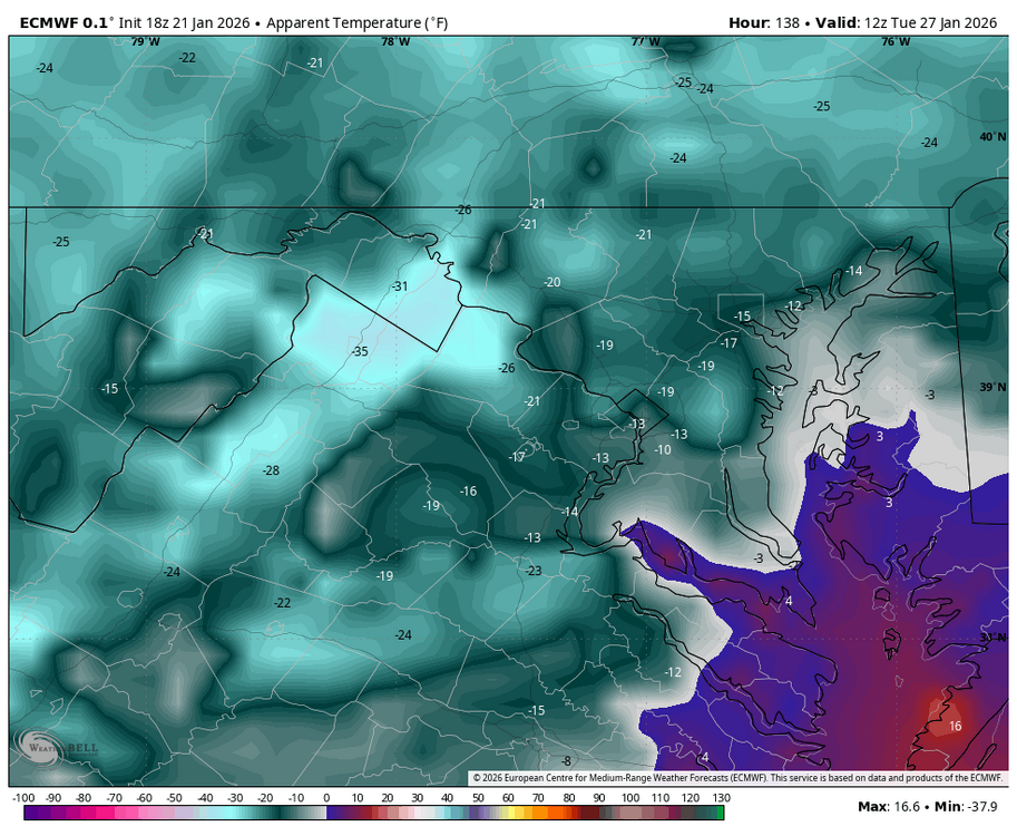
WB 18Z EURO....incredibly cold Tuesday am.....air and wind chills.
-
Well just announced. ( Flash’s idea) Bam is selling pillows!!!!
-
This data will apparently be on both GFS and Euro 0z models. Come on GFS, make me proud to be an American
-

Possible Record Breaking Cold + Snow Sunday 1/25 - Tuesday 1/27
NYER72 replied to TriPol's topic in New York City Metro
i remember being on the forums for that 2015 storm where we got a dusting and not storm of the century. There was a lone voice saying 'aint happening' can't recall. People really invested and lost their S?$t! -
Ensembles /AI vrs the Ops. Who wins….