All Activity
- Past hour
-

2026 Mid-Atlantic Severe Storm General Discussion
GramaxRefugee replied to Kmlwx's topic in Mid Atlantic
Dog's vet office on Crownsville Rd sent a text this morning that they still don't have power and several trees are blocking access. Can't open today. -
June 13 1991: One fatality and 5 injuries occur when lightning strikes a tree at Hazeltine Golf Course during the US Open. 1930: A tornado hits the Northfield area, and causes heavy damage at Randolph. For Saturday, June 13, 2026 1889 - Forest fires in northern Wisconsin and northeast Minnesota were in the process of destroying millions of dollars of board feet of timber. (David Ludlum) 1907 - The temperature at Tamarack, CA, dipped to 2 degrees above zero, the lowest reading of record for June for the U.S. The high that day was 30 degrees. Tamarack received 42 inches of snow between the 10th and the 13th. On the 13th the snow depth was 130 inches. (The Weather Channel) 1984 - Severe thunderstorms struck Denver deluging the city with five inches of rain, and leaving up to six feet of water in some places. Softball size hail smashed windshields and ripped through metal cars. Snow plows had to be called out. (The Weather Channel) 1987 - Fifteen cities in the north central U.S. reported record high temperatures for the date, including International Falls, MN, with a reading of 92 degrees. Mason City IA and Waterloo IA reported record highs of 100 degrees. Thunderstorms in the northeastern U.S. produced golf ball size hail around Hamilton Square NJ, along with high winds which tore the roof off a hospital causing a million dollars damage. Averill Park NY was deluged with 1.64 inches of rain in fifteen minutes. (Storm Data) (The National Weather Summary) 1988 - Afternoon thunderstorms produced severe weather in the Southern and Central Plains Region. Forrest NM was deluged with 5.5 inches of rain in ninety minutes. Temperatures soared into the 90s across much of the eastern half of the nation, including New England. Northern Illinois reported a record twenty straight days of dry weather. (The National Weather Summary) 1989 - Thunderstorms produced severe weather from the Southern Plains Region to the Carolinas during the day and night, and continued to drench parts of Texas and Oklahoma with heavy rain. Oklahoma City reported 13.41 inches of rain for the first thirteen days of the month, and Fort Worth TX reported 29.56 inches for the year, a total more than 13 inches above normal. Severe drought continued to rage across South Texas. (The National Weather Summary) Observances: 13 Sat Global Wellness Day 13 Sat National Sewing Machine Day 13 Sat World Softball Day 13 Sat International Albinism Awareness Day 13 Sat National Weed Your Garden Day 13 Sat Feast of St. Anthony 13 Sat International Axe Throwing Day 13 Sat National Chamoy Day 13 Sat National Dance/Movement Therapy Advocacy Day 13 Sat National Jane Day 13 Sat National Kitchen Klutzes of America Day 13 Sat National Productive Business Civility Day 13 Sat Random Acts of Light Day
-
2008 and 2012 both had a "heater" period where things just wanted to pop off more often that year. Obviously it's probably due to persistence and various patterns wanting to repeat for a little while (same as in winter for us sometimes!). 2011 as well - heck....looking back that was a HOT period of years clustered together.
-

super el nino banter thread
snowman19 replied to forkyfork's topic in Weather Forecasting and Discussion
The cope this year has been unlike anything I’ve ever seen in all my years of being a weather hobbyist….There’s no way we are getting a super El Niño. It’s only going to be weak or moderate, too close to 2023’s super event. It’s a Modoki. Ok, it’s only going to peak at moderate. It’s going to turn into a Modoki. The April WWB is weakening and falling apart. There’s La Niña hangover and the easterlies and trades will be fighting back at the end of April and May. The sea level heights aren’t rising in the EPAC. The April DWKW is weakening, falling apart and it’s not going to be a record breaker. There’s not going to be westerlies and another WWB in June. The subsurface isn’t going to be record breaking, the subsurface is not that impressive, it’s cooling off. The SSTs aren’t warming at all. The SSTs are lagging. The MJO is going to get stuck in the Niña phases and not make it into the Pacific. It’s going into the COD. Where’s the ERWs? The warm pool is stuck in the WPAC and not moving. The models are losing the triplet and twin cyclones. It’s not coupling at all. The SOI isn’t going to stay in El Niño mode, it’s not cooperating at all, it’s stuck in Niña mode. There isn’t going to be another DWKW in June. Where’s the -SOI? It’s going to rapidly weaken to neutral by winter. It’s going to peak very early. All the models are way too warm, warm bias and are overamping it. The models are going to back off. The OLR and convection isn’t cooperating, it’s staying in the eastern IO and Maritime Continent. There’s going to be a -IOD. The ++PMM isn’t going to force an east-based event. It looks central based. Where’s the STJ?…..The atmosphere is Niña-like. The PDO is negative, it’s not going to allow a super event. -PDO is fighting it And on and on….. -

Central PA Summer 2026 Discussion/Obs Thread
Mount Joy Snowman replied to Voyager's topic in Upstate New York/Pennsylvania
Low of 64 and man do things feel better out today. Last baseball game for the boy today and then a mow. All eyes on tomorrow. Also, what a performance by the USA men’s team last night. -
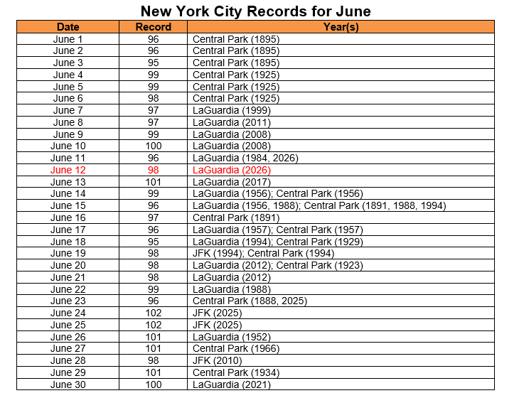
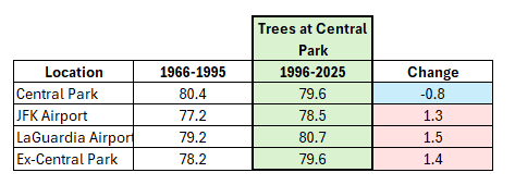
Yesterday saw record heat in New York City with LaGuardia Airport hitting 98° and JFK Airport coming in a close second at 96°. So far, there have been three days where Central Park has been New York City's coolest location: June 7: Central Park: 81°; JFK Airport: 86°; LaGuardia Airport: 83° June 11: Central Park: 91°; JFK Airport: 95°; LaGuardia Airport: 96° June 12: Central Park: 90°; JFK Airport: 96°; LaGuardia Airport: 98° The June 1-12, 2026 Average High Temperatures are below: Central Park: 82.4° (trees) JFK Airport: 82.7° (sea breeze prone) LaGuardia Airport: 84.4° Even as New York City has been warming over the most recent 30 years (1996-2025 vs. 1966-1995) during June, Central Park has seen its high temperatures cool on account of the increased tree cover. This outcome is not novel. This ongoing real-world experiment in allowing tree growth to proceed at Central Park's temperature station is producing results that are consistent with the outcomes documented in the empirical literature. One recent study concerning the cooling effect of trees can be found here.
-
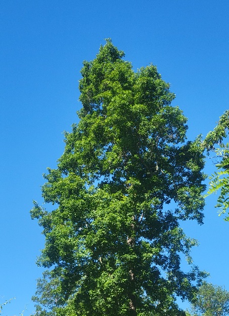
Trees are at their peak. All downhill from here. Pollen just about past. Pollen cones dropping like crazy from the pine trees. Full out hickory.
-
Shannon Hoon pattern down there At least your grass is more alive than he is
-
It may be drier than yesterday, but 63-degree dewpoints still feel pretty miserable when you have a half-hour's walk home from the supermarket, carrying 20 pounds of groceries!
-
We have been fortunate in the ATL area with plentiful rain, and temps "only" in the low 90's the last few days. Dare I say nice? I mean compared to people in the 100's, i guess it is. Looks like storms, and rain kick up again starting Monday evening through the next week after that. I am hopeful some that missed out closer to the coast can cash in this time.
-
Two TS last evening totaling 0.88". First one (7-8 PM) began with a few giant drops - sounded like hail hitting the car - then 0.10" in 2 minutes followed by less intense rain. 2nd one came 10:30-11 PM and added 0.33".
-
I think this might be one of those summers where August could rock as far as thunderstorms. Like one of those early 1990s ones. 63 for the low. Up to 71 now
-
Great for splitting and stacking firewood, for the garden not so much.
- Today
-
It’s hard to get overly excited for organized severe weather or a higher end severe potential without any signals of an EML. But if we can get dews into the 70’s with strong shear and height falls we can get swaths of wind damage
-

2026 Mid-Atlantic Severe Storm General Discussion
dailylurker replied to Kmlwx's topic in Mid Atlantic
Maybe we're on a hot hand. Last evening an orange thunderstorm rolled through around sunset. Just east of me got blased with a downburst as the storm started to collapse. I might ride down 450 and check it out later on. -
Glad we could break 94/75 with no rain. God does SNE suck.
-
As warm/hot as it has been past couple of days, no records here. High yesterday before storms rolled in was 90.1 degrees, record is 92 from 1984. Got 0.14" from the storm, every drop counts!
-
Who cares
-
Scored .24" last evening in a T-Shower. Better than nothing I suppose. Air has better "feel" to it this morning. The humidity yesterday was foul. Cleaner air mass in place with deep blue skies. Still no Canadian smoke this season, that's a plus.
-
Departures through Jun 12th EWR: +5.2 JFK: +4.8 LGA: +4.4 NYC: +3.8
-
Records: Highs: EWR: 99 (2017) NYC: 96 (1961) LGA: 101 (2017) JFK: 95 (1983) Lows: EWR: 51 (1982) NYC: 51 (1953) LGA: 51 (1982) JFK: 51 (1980) Historical: 1586: (23 June current calendar) Roanoke Colony, North Carolina: First European report of waterspout off US coast by Ralph Lane, a member of Sir Francis Drake's fleet: "There were great spouts at the seas as though heaven and earth would have met." (Ref. WxDoctor) 1889 - Forest fires in northern Wisconsin and northeast Minnesota were in the process of destroying millions of dollars of board feet of timber. (David Ludlum) 1907 - The temperature at Tamarack, CA, dipped to 2 degrees above zero, the lowest reading of record for June for the U.S. The high that day was 30 degrees. Tamarack received 42 inches of snow between the 10th and the 13th. On the 13th the snow depth was 130 inches. (The Weather Channel) 1955: Water from the Spring Mountains swept down on Las Vegas, NV after a violent thunderstorm of rain and hail, virtually isolating the City, flooding hundreds of homes and stores and causing an untold amount in property damage. Residents of the Twin Lakes Subdivision reported that a four-foot wall of water came down from the slope of Mt. Charleston. Hardest hit was the Brentwood Park Tract, where large stocks of lumber, stacked for construction on new homes, were washed away by the flood, and littered the Municipal Golf Course and Twin Lakes Subdivision. (Ref. Wilson Wx. History) 1956: Boston, Massachusetts recorded peak gust of 84 mph gusts during a thunderstorm. (Ref. NOAA Boston Weather Events) 1967: Three separate lines of thunderstorms developed and raced across eastern South Dakota. The storms dumped up to 5 inches of rain and hail the size of golf balls was common. Winds gusted to 71 mph in the Aberdeen area resulting in some damage. Crop damage was 100% in some areas in the northeast due to the relentless hail and flooding rains. (Ref. Wilson Wx. History) 1968: A violent F5 tornado killed 9 people at Tracy, MN. Over 110 homes were destroyed, while a steel I-beam was reportedly carried for 2 miles on a piece of roof. Two farms hit by this tornado were also hit by a violent F4 tornado on 6/24/1924.(Ref. Wilson Wx. History) 1969: 10 inches of snow fell in Deerfield, SD as an unusual late season storm covered parts of South Dakota, Wyoming, Montana and Nebraska. Five inches of snow was measured at Great Falls, MT. The low temperature at Billings, MT fell to 32°, their latest freeze on record. The temperature also fell to 32° the previous day; both tying a record low for the month of June. (Ref. Wilson Wx. History) 1973: Dust devils are not tornadoes, but they can still lift heavy objects. At Jennison, MI, a dust devil picked up a rug, stepladder, and a patio umbrella. It also lifted a 350-lb concrete patio table and dropped it 3 feet away (in several pieces after the landing). (Ref. Weather Guide Calendar with Phenomenal Weather Events 2011 Accord Pub. 2010, USA) 1976: A deadly tornado moved across parts of the southwestern Chicago, IL suburbs killing two people and injuring 23 others. The tornado, with winds over 200 mph moved from Lemont to Downers Grove causing $13 million dollars in damage when 89 homes were destroyed and another 90 were damaged. The tornado passed over the Argonne National Laboratory, peeling part of a roof off the building housing a nuclear reactor. The tornadoes movement was rather erratic moving southeast the north and finally turning northwest. (Ref. Wilson Wx. History) 1984 - Severe thunderstorms struck Denver deluging the city with five inches of rain, and leaving up to six feet of water in some places. Softball size hail smashed windshields and ripped through metal cars. Snow plows had to be called out. (The Weather Channel) 1987 - Fifteen cities in the north central U.S. reported record high temperatures for the date, including International Falls, MN, with a reading of 92 degrees. Mason City IA and Waterloo IA reported record highs of 100 degrees. Thunderstorms in the northeastern U.S. produced golf ball size hail around Hamilton Square NJ, along with high winds which tore the roof off a hospital causing a million dollars damage. Averill Park NY was deluged with 1.64 inches of rain in fifteen minutes. (Storm Data) (The National Weather Summary) 1988 - Afternoon thunderstorms produced severe weather in the Southern and Central Plains Region. Forrest NM was deluged with 5.5 inches of rain in ninety minutes. Temperatures soared into the 90s across much of the eastern half of the nation, including New England. Northern Illinois reported a record twenty straight days of dry weather. (The National Weather Summary) 1989 - Thunderstorms produced severe weather from the Southern Plains Region to the Carolinas during the day and night, and continued to drench parts of Texas and Oklahoma with heavy rain. Oklahoma City reported 13.41 inches of rain for the first thirteen days of the month, and Fort Worth TX reported 29.56 inches for the year, a total more than 13 inches above normal. Severe drought continued to rage across South Texas. (The National Weather Summary) 1991: Lightning struck a tree at the U.S. Open Golf Tournament being held at Chaska, MN. One spectator was killed, and six others were injured. (Ref. Wilson Wx. History) 1993: Four inches of rain fell in one hour on Lenox, IA as the Great Mississippi Flood of 1993 was beginning. (Ref. Wilson Wx. History) 1994: A series of violent thunderstorms roared across parts of western and central New York. The thunderstorm winds downed trees and power lines. A tornado touched down in the town of Freedom. Damage was intermittent along the mile long path, with only tree damage for the first 3/4 mile. Over its last quarter mile the tornado destroyed a 25 x 25 foot garage. The tornado then struck the Pleasantview Mobile Home Park. A roof which was blown off one mobile home penetrated the wall of another home about 200 feet away. Two other mobile homes were lifted and moved off their foundations. The thunderstorms dropped between two and four inches of rain which produced flash flooding. One hundred basements were flooded in Jamestown. Damage from flash flooding was extensive in Allegany State Park in Cattaraugus County. Two recreational bridges collapsed and other major bridges were undermined. Beaches were damaged extensively and roads were washed out. In one instance, the blacktop from one road was carried over 20 feet. (Ref. Wilson Wx. History) 2002: As thunderstorms roared through Ponca City, OK with lots of large hail and wall clouds, lightning caused a fire at a Conoco refinery. The news immediately sent gasoline futures higher by 50 points. The refinery was back on line quickly, but gasoline prices rose a few extra cents in time for the Fourth of July Holiday. (Ref. Wilson Wx. History) 2005: Low pressure, the remnants of Hurricane Arlene, moved northeast across the Great Lakes. The bands of showers and thunderstorms produced damage across parts of the Niagara Frontier and Finger Lakes. Heavy rains produced flash flooding in Livingston County, an area which received heavy rains on several consecutive days. The strong winds downed trees and limbs in Le Roy, Stafford, Mendon, Livonia, Lockport, Kendall, and Clarkson. (Ref. Wilson Wx. History)
-
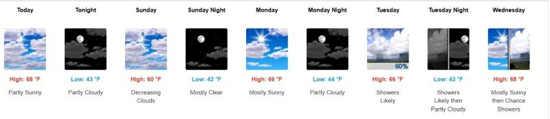
75 / 59 much drier today. wonderful day on tap warm / dry and sunny upper 80s - low 90s making it a heatwave for some. Tomorrow warm/ and potentially stormy later in the evening and overnight as the front comes through, pending on clouds mid 80s to low 90s. Cooler Mon - Wed then a brief surge of dew points and temp Thu (next shot at 90) before next front comes through. The period 6/19 - 6/24 trough generally into the Midwest / northeast looks overall near normal to slightly above and features storm chances. Beyond there and through the close of the month near to above normal with next heat chance as we move into next month.
-
Just based on feel, being out and about in Manhattan there was no was it was a run of the mil around 90 degree day. It had to be mid to upper 90s out. The Park was especially lagging yday considering we haven't had alot of heavy rain lately. It doesnt make sense that even the heliport downtown was running ahead of the Park and their sensor is sitting on a pier sticking out into the East River, just about to open into Upper NY Bay.
-
-
Got down to 74 for the low before started warming up. Sun already baking!


