All Activity
- Past hour
-
Yeah yesterday was impressively cold.
-

Clipper Fires In Wednesday Feb 25 Disco/ Obs
weatherwiz replied to Damage In Tolland's topic in New England
I actually wouldn't be surprised if the degree of warming temps is a bit understated, especially during the precip. Possible maybe we see some late afternoon highs? -

Central PA Winter 25/26 Discussion and Obs
Superstorm replied to MAG5035's topic in Upstate New York/Pennsylvania
Agree. After that last storm, seeing anything else that’s not going to have staying power is useless. Unless you’re looking to pat the stats. I’m already geared up for baseball! . -

Clipper Fires In Wednesday Feb 25 Disco/ Obs
Sey-Mour Snow replied to Damage In Tolland's topic in New England
HRRR has areas in SEMASS shooting up 37 degrees in 3 hours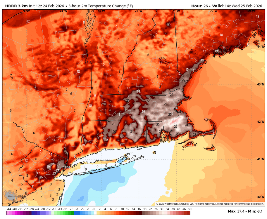
-

"Don’t do it" 2026 Blizzard obs, updates and pictures.
SeanInWayland replied to Ginx snewx's topic in New England
Very likely he's drawing these from the list by dates of notable events in Ludlum's American Weather Book. It really should be more properly titled New England Weather Book, as most of the discussion, anecdotes, and history is centered on Northeast US weather. It's a great read, and especially so for any budding weather enthusiast you might know. -
Clipper Fires In Wednesday Feb 25 Disco/ Obs
Sey-Mour Snow replied to Damage In Tolland's topic in New England
Wild WAA temps start in the teens and even some single digits with first flakes then halt up 20 degrees in 2-3 hours , won’t be much road stickage with temps like that on the south coast and valleys. -
Clipper Fires In Wednesday Feb 25 Disco/ Obs
weatherwiz replied to Damage In Tolland's topic in New England
Yup. And I think we should be relatively active right up to probably mid-March. Don't see a hole heck of a lot too screaming warm so we're going to have potential to continue adding to seasonal totals for sure -
15.6" for the event here as of 7am. Been snowing more this morning too.
-

Central PA Winter 25/26 Discussion and Obs
Itstrainingtime replied to MAG5035's topic in Upstate New York/Pennsylvania
Yep, and that was my point. Despite it being a dark, overcast day yesterday, there was enough solar radiation to do it's damage on my snow cover. When the sun angle is lowest the radiation is really mitigated. That's why I covet holiday snow...it coincides with the best staying power season. -
Clipper Fires In Wednesday Feb 25 Disco/ Obs
Sey-Mour Snow replied to Damage In Tolland's topic in New England
That includes Thursday night snow -

Clipper Fires In Wednesday Feb 25 Disco/ Obs
Spanks45 replied to Damage In Tolland's topic in New England
This winter in particular....it seems like we get into these 1 week periods where it just wants to snow, then we go another week or 2 that it doesn't want to. Upcoming period definitely fits that pattern again -

Clipper Fires In Wednesday Feb 25 Disco/ Obs
Damage In Tolland replied to Damage In Tolland's topic in New England
Not here. This one looks good . Solid 2-3” outside shot at 4” -

Winter 2025-26 Medium/Long Range Discussion
A-L-E-K replied to michsnowfreak's topic in Lakes/Ohio Valley
this is our moment -
solid 12" out in Gardner.
-

Winter 2025-26 Medium/Long Range Discussion
cmillzz replied to michsnowfreak's topic in Lakes/Ohio Valley
Take a look at this morning’s AI GFS for a laugh, it’s a literal March 2012 redux. Fun to look at, but I’m sure it’ll be mild at times. -

2025-2026 ENSO
donsutherland1 replied to 40/70 Benchmark's topic in Weather Forecasting and Discussion
Ray, you did an exceptional job. Those of us who read your work appreciate the time you devote and the value your insights and effort bring. -
Records: Highs: EWR: 74 (2017) NYC: 75 (1985) LGA: 73 (1985) JFK: 62 (2017) Lows: EWR: 4 (2015) NYC: -1 (1873) LGA: 6 (2015) JFK: 7 (2015) Historical: 1852 - The Susquehanna River ice bridge at Havre de Grace, MD, commenced to break up after forty days of use. A total of 1738 loaded freight cars were hauled along rails laid on the ice. (David Ludlum) 1870: Professor Cleveland Abbe began preparing the Western Union Telegraph Company's Weather Report, a plotted daily weather map issued 6 days a week. The cooperation of the telegraph companies were critical to the survival of our early national weather network. They provided free transmission time and priority handling for weather messages. (Ref. Wilson Wx. History) 1905: The temperature at Valley Head, AL fell to -18°. This was the coldest temperature ever recorded in Alabama until January 1966. (Ref. Wilson Wx. History) 1910: Washington state's greatest snowstorm dumped 129 inches of snow on Laconia, WA over 3 days. (Ref. Wilson Wx. History) 1936 - Vermont and New Hampshire received brown snow due to dust from storms in the Great Plains Region. A muddy rain fell across parts of northern New York State. (24th-25th) (David Ludlum) (The Weather Channel) 1936: End of longest snow cover in modern history of a 37 days period from January 19th to February 24th in Washington, DC. (Ref. Washington Weather Records - KDCA) Vermont and New Hampshire received brown snow due to dust from storms in the Great Plains Region. A muddy rain fell across parts of northern New York State. (24th-25th) (David Ludlum) (The Weather Channel) 1962: Snow, sleet, freezing rain and severe thunderstorms in southern New England occurred. $5 million in property damage resulted. (Ref. Wilson Wx. History) 1969: The famous "100-Hour Storm" began in Boston, MA. Snow often fell between early on the 25th and noon on the 28th. The 26.3 inches at Logan Airport is the 2nd most significant snowstorm in Boston's history. In addition, 77 inches fell at Pinkham Notch Base Station in New Hampshire, bringing their February total to 130 inches. Their snow cover on the 27th was 164 inches. Mt. Washington, NH, received 172.8 inches of snow in the month. 1987 - A massive winter storm began to overspread the western U.S. In southern California, Big Bear was blanketed with 17 inches of snow, and Lake Hughes reported four inches of snow in just one hour. Snow pellets whitened coastal areas of Orange County and San Diego County, with three inches at Huntington Beach. The storm also produced thunderstorms with hail and waterspouts. (The National Weather Summary) (Storm Data) 1988 - Strong winds produced snow squalls in the Great Lakes Region which created "white-out" conditions in eastern Upper Michigan. Squalls produced up to 14 inches of snow in Geauga County of northeastern Ohio. (The National Weather Summary) (Storm Data) 1989 - A total of thirty-three cities in the eastern U.S. reported new record low temperatures for the date, and an Atlantic coast storm spread heavy snow from Georgia to southern New England. Snowfall totals in New Jersey ranged up to 24 inches in May County, with 19 inches reported at Atlantic City. Totals in North Carolina ranged up to 18 inches in Gates County, and winds along the coast of North Carolina gusted to 70 mph at Duck Pier. Strong winds gusting to 52 mph created blizzard conditions at Chatham MA. (The National Weather Summary) (Storm Data) 1990 - Strong northerly winds prevailed from Illinois to the Southern and Central Appalachians. Winds gusted to 68 mph at Sewickley Heights PA. High winds caused considerable blowing and drifting of snow across northern and central Indiana through the day. Wind gusts to 47 mph and 6 to 8 inches of snow created white-out conditions around South Bend IN. Traffic accidents resulted in two deaths and 130 injuries. Sixty-five persons were injured in one accident along Interstate 69 in Huntington County. Wind gusts to 60 mph and 4 to 8 inches of snow created blizzard conditions in eastern and northern Ohio. (The National Weather Summary) (Storm Data) 1994 Record Cascade snowstorm in Washington State 65 inches in 24 hours at Crystal Mountain sets state record. Stampede Pass at 4,500 feet gets 30 inches giving a total on the ground of 94 inches. (Bob Ryan's 2002 Almanac) 1996 Today marked the 54th consecutive day in San Antonio, TX without measurable precipitation, their 2nd longest rain-free period. (Ref. Wilson Wx. History) 2000 A late evening F3 tornado cut a 23 mile long path through Pontotoc County, Mississippi, killing 7 people. In spite of the nearest National Weather Service Doppler Radar not working, warnings were in effect for the tornado. Nearly 300 homes were damaged or destroyed. Other F2 tornadoes were reported in Mississippi and several twisters touched down around Little Rock, AR, all spawned by the same system. (Ref. Wilson Wx. History) 2001: In a house without a basement, a small interior room/closet on the 1st floor often provides the best area for tornado survival. In Greenwood, MS, a F3 tornado destroyed all but the 1st floor bathroom of a 2-story house. A family of 4 survived in that room. (Ref. Weather Guide Calendar with Phenomenal Weather Events 2011 Accord Pub. 2010, USA) 2004: Northern New Mexico: Heavy snows blanket wide areas of northern New Mexico, closing schools and highways. Snow accumulates to 20 inches on the mountains east of Santa Fe; Sandia Park, east of Albuquerque, measures 11 inches ; 8 inches falls at Los Alamos. (Ref. WxDoctor) 2012: The maximum temperature here today was 81 °F which is the highest temperature since March 18, 2011 when it was 82 °F. The maximum temperature yesterday was 81 °F at the Richmond International Airport which was only one degree from the record maximum temperature for the date. (Records since 1897) This maximum was also only 2 °F from the warmest temperature ever recorded in the month of February which was 83 °F recorded on February 11, 1932.(Records since 1897) The high wind gust yesterday was 46 mph at 15:03 hours which was the highest gust since Hurricane Irene on August 27, 2011 when a 52 mph gust was recorded. A great temperature decrease of -28.3 °F since yesterday at 7:10 AM. The total precipitation yesterday was only 0.03 inches and for Feb. 1.98 inches and thunder was heard twice. (West Henrico Co. - Glen Allen Virginia Weather Center) 2001: Over a dozen tornadoes spawned in central and eastern Arkansas. The strongest tornado (F3) was in Desha County, with parts of a farm shop found six miles away from where it was blown apart. An 18-month-old was killed in Fulton County by an F2 tornado. 2004 - Heavy snows blanket wide areas of northern New Mexico, closing schools and highways. he mountains east of Santa Fe receive 20 inches. Sandia Park, east of Albuquerque, measures 11 inches. 8 inches falls at Los Alamos. 2007: An EF3 tornado struck Dumas, Arkansas, injuring 28. Seven other tornadoes hit southeast Arkansas on this day, but no fatalities. 2016: A strong area of low pressure along with a cold front produced a severe weather outbreak from North Carolina to Pennsylvania. Not one but two rare February tornadoes occurred in central Virginia. The strongest tornado caused EF3 damage in Appomattox County. This is the first EF3 tornado ever in Appomattox County.
-

Blizzard of 2026 Storm Thread/OBS
Violentweatherfan replied to Mikeymac5306's topic in Philadelphia Region
How long did that sit over the area -

Central PA Winter 25/26 Discussion and Obs
Voyager replied to MAG5035's topic in Upstate New York/Pennsylvania
Actually, I was going to ask about that. Does anyone have stats on cloudy vs sunny days? Besides the cold and wind, it seems like it's been exceptionally cloudy this winter. -

"Don’t do it" 2026 Blizzard obs, updates and pictures.
wxeyeNH replied to Ginx snewx's topic in New England
I'm happy with my 1/4" of snow and more happy for the people who got 35 to 40". I see lots of pictures of people posting snowbanks and drifts. I'm looking for a video clip of someone who is able to drive and just video a neighborhood that got that much. Cars and areas not plowed should be pretty much buried. It is a good way to really judge. Most social media posts want to show the highest snowbank or drifted area. I just one to see a longer, honest video in the ground zero area. If anyone has a link I would love to see it! -

Winter 2025-26 Medium/Long Range Discussion
SchaumburgStormer replied to michsnowfreak's topic in Lakes/Ohio Valley
You know as well as I do that we are going to get smacked by an unwanted 8" of cement in late April. -
since my dogs got used to walking on top of the other snow pack, they thought they could do the same this time, with disastrous results....poodle hair is like velcro for snow....
-
Winter 2025/26 Banter Thread
SchaumburgStormer replied to Chicago Storm's topic in Lakes/Ohio Valley
This sounds like fun, but as I work in commercial property insurance, all I can thin k about are collapsed roofs and trees on houses due to the weight. But 10/10 would love to see something like that, or a Buffalo lake effect firehouse in person before I kick the bucket. -
The original post and point remains…your call for back broken a couple weeks back was incorrect. That’s all. It’s ok to admit a mistake.
-
Crazy how widespread the 20"+ was with this storm in Suffolk. You can also see of areas around ISP with similar totals. 0310 PM 02/23 Cocorahs ...Suffolk County... Central Islip 31.0 in 0140 PM 02/23 Trained Spotter 1 NNW East Islip 30.0 in 0140 PM 02/23 Fire Dept/Rescue North Patchogue 30.0 in 0135 PM 02/23 Public 1 SW Babylon 29.5 in 1124 AM 02/23 Amateur Radio Islip 29.1 in 0100 PM 02/23 Official NWS Obs 1 WNW Holbrook 29.0 in 1200 PM 02/23 Public 1 W Nesconset 28.8 in 1243 PM 02/23 1 W Shirley Airport 28.5 in 0119 PM 02/23 Public Bay Shore 28.2 in 1200 PM 02/23 NWS Employee Montauk 28.1 in 1230 PM 02/23 Public 2 N Medford 27.8 in 0300 PM 02/23 Trained Spotter 2 SE East Farmingdale 27.5 in 0330 PM 02/23 Trained Spotter Remsenburg-Speonk 27.5 in 1013 AM 02/23 Public Fort Salonga 1.5 SSE 27.2 in 0230 PM 02/23 COCORAHS Orient Point 26.5 in 0300 PM 02/23 COOP 1 SSE Quogue 26.0 in 0934 AM 02/23 Public 1 NE Southampton 26.0 in 0250 PM 02/23 Public 2 NNW Islip 25.3 in 0221 PM 02/23 Public 2 NNW Lindenhurst 25.0 in 1139 AM 02/23 Fire Dept/Rescue 2 ENE Shinnecock Hills 25.0 in 1114 AM 02/23 Bay Shore 24.7 in 1230 PM 02/23 COCORAHS Lindenhurst 24.3 in 0300 PM 02/23 Public 4 WSW Davis Park 24.2 in 0200 PM 02/23 Public Babylon 24.0 in 1242 PM 02/23 Amateur Radio 2 NNW Ridge 24.0 in 1000 AM 02/23 Trained Spotter 2 NW Southampton 24.0 in 0911 AM 02/23 Public 1 NNE Islandia 23.5 in 0100 PM 02/23 Public Mattituck 23.3 in 0130 PM 02/23 Trained Spotter 2 E Flanders 23.0 in 0137 PM 02/23 Public 1 ESE Hauppauge 23.0 in 0330 PM 02/23 Public 1 S Islip Terrace 23.0 in 1130 AM 02/23 Trained Spotter Islip Terrace 0.5 W 23.0 in 0900 AM 02/23 COCORAHS 1 NE Lake Ronkonkoma 23.0 in 1104 AM 02/23 NWS Employee 2 SW Middle Island 23.0 in 1014 AM 02/23 Selden 1.6 ESE 23.0 in 0130 PM 02/23 COCORAHS West Islip 22.8 in 0200 PM 02/23 Trained Spotter Manorville 22.0 in 0205 PM 02/23 Public 1 SW Shelter Island 21.1 in 1000 AM 02/23 Amateur Radio 1 SE East Northport 21.0 in 0200 PM 02/23 Public 2 ENE Ridge 20.7 in 0124 PM 02/23 Trained Spotter Oakdale 20.5 in 0200 PM 02/23 Trained Spotter 3 WNW Riverhead 20.2 in 0630 PM 02/23 NWS Employee 1 ESE East Patchogue 20.0 in 0300 PM 02/23 NWS Employee Nesconset 20.0 in 0940 AM 02/23 COCORAHS