
All Activity
- Past hour
-
active pattern today... line after line.
-

2026 Mid-Atlantic Severe Storm General Discussion
Eskimo Joe replied to Kmlwx's topic in Mid Atlantic
PA and NY stole this week from us. -
Hrrr seems to eventually wake up. NAM has been awful this year. Limping to the grave lol. FV3 and Herpderp seem to do decently.
-

Septorcher 2026 Discussion - Endless Summer
SouthCoastMA replied to Damage In Tolland's topic in New England
That's what I have. Only 1 storm produced above that since July 31st, which was .29". -
The Nam nor hrrr had been handling storms well. Even the bow line in western pa right now just shows it fall apart every run after an hour but yet it is still there every hour lol.
-
-

Septorcher 2026 Discussion - Endless Summer
Typhoon Tip replied to Damage In Tolland's topic in New England
Actually yeah... can almost see a pathway to improvement - yup, right when I f'n clicked Submit Reply. Told ya The visible loop now better exposes that there are two main ceiling layers. The higher one is moving exceptionally fast for this time of year... That's another thing. wow. Perceived 'back edge' moved from near Syracuse NY at dawn, to almost Albany in 1.5 hours. Some 150 miles ? that's 100mph. That seems a bit fast for September 1? more like a flat flow in winter thing. interesting. Anyway, depending on the underwear in this scenario...as the upper peals away here over the next couple of hours we'll see how much grunge lingers frumunda - -

Central PA Summer 2026 Discussion/Obs Thread
mahantango#1 replied to Voyager's topic in Upstate New York/Pennsylvania
-
JB has invoked 1925 where we had a record warm September followed by a very cold October. He thinks that it will cool down in October significantly. Me...it's gonna be the warm and droughty base state until it isn't. No signs of change yet.
-
 best online pharmacy no prescription: QuickPh :: new pharmacy online
 -

Septorcher 2026 Discussion - Endless Summer
CoastalWx replied to Damage In Tolland's topic in New England
Will make a quarter inch anyways. -
I know it’s mostly heat stress, but noticing a variety of species with some fall color this morning.
-
The Graf scored closer to reality than the NWS for Staunton/Waynesboro yesterday evening. Staunton/Waynesboro didn't get a drop. NWS says 60% this pm while Graf says 41%............... With an approaching front tomorrow that will stall over the Central Valley for Saturday, my probs. crawl up from 30% today to 40% for Friday and 50% on Saturday.
-
More mid 90s/mid 100 heat indices today and tomorrow, and then slowly starts to downtrend. Much drier air may be on the way by later next week.
-

2026 Mid-Atlantic Severe Storm General Discussion
batmanbrad replied to Kmlwx's topic in Mid Atlantic
well, at least CSU-MLP thinks much of our area is in the sweet spot for 30% wind damage probabilities for tomorrow, so even if today turns out to be meh, there's hope: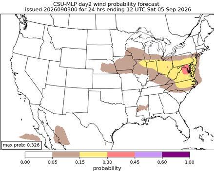
-
Septorcher 2026 Discussion - Endless Summer
Typhoon Tip replied to Damage In Tolland's topic in New England
I only glanced at the NAM so probably low scoring anyway, but the front appears behind schedule relative to what I saw. Supposed to be thru the region far enough to improve skies and elevate temperatures all the way to Logan by 2pm. Looking at morning satellite, doesn't lend much confidence of those two metrics laying into the area, huh. I'm routinely wrong in this morning arm chair analysis shit, though. I always see them pessimistically and then usually ... the moment I click 'Submit Reply' it was as though the button really said should, 'Clear skies and warm up anyway' hidden from me. So we'll see. -
(002).thumb.png.6e3d9d46bca5fe41aab7a74871dd8af8.png)
Central PA Summer 2026 Discussion/Obs Thread
ChescoWx replied to Voyager's topic in Upstate New York/Pennsylvania
Some more impressive rain totals since yesterday. Atlgen 1.59" / Chester Springs 1.40" / East Nantmeal 1.80" / Warwick 1.32" / Devault 1.78" / Kennett Square 1.22" / West Bradford 2.01" / Avondale 2N 0.80" /West Chester 1.29" and West Grove 0.92" -

Central PA Summer 2026 Discussion/Obs Thread
anotherman replied to Voyager's topic in Upstate New York/Pennsylvania
It’s literally like living in the tropics. I cannot wait for this disgusting air to be swept out of here tomorrow. -
Where’s my moderate risk?
-
ORD holding around 80, better not sneak a 79
-
I believe that it was Joe Bastardi that said around the time that Katrina hit Florida that a strenghening Cat 1 storm could cause more damage than a stable or weakening Cat 3 storm?
-
That line near Pittsburgh should die as it enters our area (our area is where storms come to die lol) but leave us with lots of clouds today. Hopefully the clouds hang on and hold the temp down. I can do without working in another 95/78 day.
-
ensembles continue to offer little to no hope for anyone banking on an early fall
-
Central PA Summer 2026 Discussion/Obs Thread
mahantango#1 replied to Voyager's topic in Upstate New York/Pennsylvania
256 FXUS61 KCTP 031135 AFDCTP Area Forecast Discussion National Weather Service State College PA 735 AM EDT Thu Sep 3 2026 .WHAT HAS CHANGED... * Issued a Flash Flood Watch for all of our CWA through Midnight this Thursday night. && .KEY MESSAGES... 1) Late summer surge of heat and humidity continues with a severe thunderstorm and excessive rainfall threat through this Thursday evening && .DISCUSSION... KEY MESSAGE 1: Late summer surge of heat and humidity continues with a severe thunderstorm and excessive rainfall threat through this Thursday evening Main change this forecast cycle was to issue a Flash Flood Watch for the entire CWA based on the current wide distribution of moderate to heavy rain and embedded/training TSRA along with a HREF/NAM/MRMS blend of short range model guidance and remote sensing. A seemingly endless train of mid/upper level impulses riding ESE along the southern edge of a persistent jet and within a region of broad upper level diffluence and anomalously high PWATs of nearly 2 inches will continue to interact with numerous, converging convective outflow boundaries to produce several more bouts of heavy showers/TSRA today through at least early tonight. Basin "Average" rainfall across the CWA will likely range between 0.75 to 1.25 inches but as we saw Wed/Wednesday night, training/and back-building TSRA could easily dump over 3 inches of rain in just an hour and lead to significant flash flooding. The target areas for the heaviest rainfall today and this evening should be the Southwest half of the CWA as a well- defined outflow boundary has pushed into southern PA early today. We do expect the airmass to recover quickly late this morning/early this afternoon as this first MCS moves SE. However, a glance just to the left shows another developing MCS close on its heels over West-Central Lake Erie. This feature is progged by high res near term model guidance to track SE twd the laurel and diminish by 14-15Z. By 19-20Z today, more TSRA fire across Northern PA and a second larger area follows for this evening over a similar part of the state that experience the heavy rain over the past 24 hours. Additionally, increased southwest to westerly flow today will continue to pump in the late summer heat and very high dewpoints. A heat advisory remains in effect from 11a-8p Thursday across a portion of south central PA where max heat index values are projected to reach/exceed 100F. As mentioned above, SPC`s severe risk are will encompass primarily the SW half of the state where ML CAPE will be the highest, but the MRGL risk area will cover practically the entire rest of Eastern PA. An upper level trough passage favors one final round of showers and storms on Friday, but fortunately the Labor Day weekend is trending dry. The upper ridge is forecast to retrograde by the end of the week which allows for a return to more seasonal temperatures and lower humidity this weekend into early next week. && -
E PA/NJ/DE Summer 2026 Obs/Discussion
ChescoWx replied to PhiEaglesfan712's topic in Philadelphia Region
Some more impressive rain totals since yesterday. Atlgen 1.59" / Chester Springs 1.40" / East Nantmeal 1.80" / Warwick 1.32" / Devault 1.78" / Kennett Square 1.22" / West Bradford 2.01" / Avondale 2N 0.80" /West Chester 1.29" and West Grove 0.92"












