All Activity
- Past hour
-

Augdewst 2026: Summer's Last Stand
vortex95 replied to Prismshine Productions's topic in New England
Hawaii looks to be impacted by a TS or min HU in about 5 days. The angle of approach is a bit atypical coming in towards the Big Island from the ESE, but it is a strong El Nino, and this results in higher potential for a strong TS/min HU direct hit in Hawaii (Iwa in 1982 is a good example) and the cntrl Pacific is more active overall in El Nino. But the system (93C currently) looks monsoonal and broad, so that should preclude any big intensification. Also, 700-500 RH drops below 60% by 60 hr and below 50% by 72 hr well before it gets to the islands, so despite above avg SSTs, low environmental RH tends to override and will limit things. Of course the MSM will act like it is end of days, as if such an event is unprecedented. I will point out this TC on 8/9/1871. A estimated cat 3 made landfall on the Big Island coming in from the ESE. To get a TC of this strength coming in from the E at that latitude for a landfall is exceptional. No other record of anything like this exitss. Iwa in 1982 and Iniki in 1992 came in from the S https://journals.ametsoc.org/view/journals/bams/99/1/bams-d-16-0333.1.xml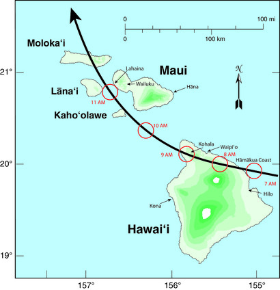
-
Right now, these cells are dying at the Catawba County border. They can't make it out of Caldwell and Alexander. I'm hoping that changes...
-
If you have Netflix, there is an excellent documentary about the Joplin Missouri tornado of May 2011. It was actually quite moving. The destruction was breathtaking.
-
Augdewst 2026: Summer's Last Stand
vortex95 replied to Prismshine Productions's topic in New England
We have a combo continental/marine climate, so we get just about everything, just less extremes in terms of frequency. Is that so bad? Prevailing westerly flow for continental influence, and the ocean right next to us for marine. 4 very distinct seasons and true variety for all types of wx. @CoastalWxneeds the marine influence for his Weymouth OES! And really, continental climate outside of mountain areas?, 8-14" is considered a monster snowstorm. So be grateful we exceed that for our definition! -
Easy now lol. I like my rain with the power on preferably.
-

Augdewst 2026: Summer's Last Stand
weatherwiz replied to Prismshine Productions's topic in New England
Thank God. IT is unfortunate because its obviously great with CAD scenarios and tends to be better with temperatures along boundaries with extensive clouds and precip but its useless 99% of the time. Oh...should add its also a bit more down to Earth where it will have 93/74 versus the 101/63 the GFS will pull. -
Get Terro bait traps and place them where you see ant traffic. Initially you may see more ants, but that's okay. Leave the ants alone and they'll take the bait with them back to the colony.
-
Augdewst 2026: Summer's Last Stand
vortex95 replied to Prismshine Productions's topic in New England
And MET is going away in Oct. -
Tornado warning for Cincy.
-
Extremely nasty cell just passed through Lenoir. Quite a bit of hail and strong winds.
-
I don't think the hideous creatures mind cold. I concluded this after years of visiting the North Country where the mosquitoes are more plentiful/annoying than here. Sorry, I don't have an explanation either. (This statement is not meant to diminish my sympathy. You are not alone. )
-
Augdewst 2026: Summer's Last Stand
vortex95 replied to Prismshine Productions's topic in New England
Yes, nice center point, and MPV airport is 1166 ft. I think one reason why it was farther W to have coverage in Upstate NY, which is part of the BTV CWA. Fortunately, the Canadian radars that were upgraded to Doppler last decade help a *lot* for NNE! On another note, today EC starts targeted (polygon-based) svr/tor warnings. https://dd.meteo.gc.ca/doc/genots/2026/08/03/NOCN04_CWAO_031225___62572 -
We have had a large amount of those "piss ants" in our kitchen since Spring. One day we wake up and find less than 10 the next day about 100. We cleared out the back of our house and found thy may have been living in where we keep our garden hose. We moved that and sprayed under the siding and it seemed to kill down about 75% of the issue. We are still getting them in the kitchen. Think that's just what's left over, or I wonder if there is another colony somewhere I haven't looked. Any ideas to keep them away?
-
Hazy, hot, and humid. Currently 95/82 for a feels like of 119.
-
Why are the mosquitoes so bad this year? It's the worst year in the past 24yrs I've lived here. It makes no sense, we had drought last year, the coldest winter in decades and then more drought this year up until just recently. I'm lucky in that I don't get actual itchy bites, but they're annoying as heck to swat off.
-
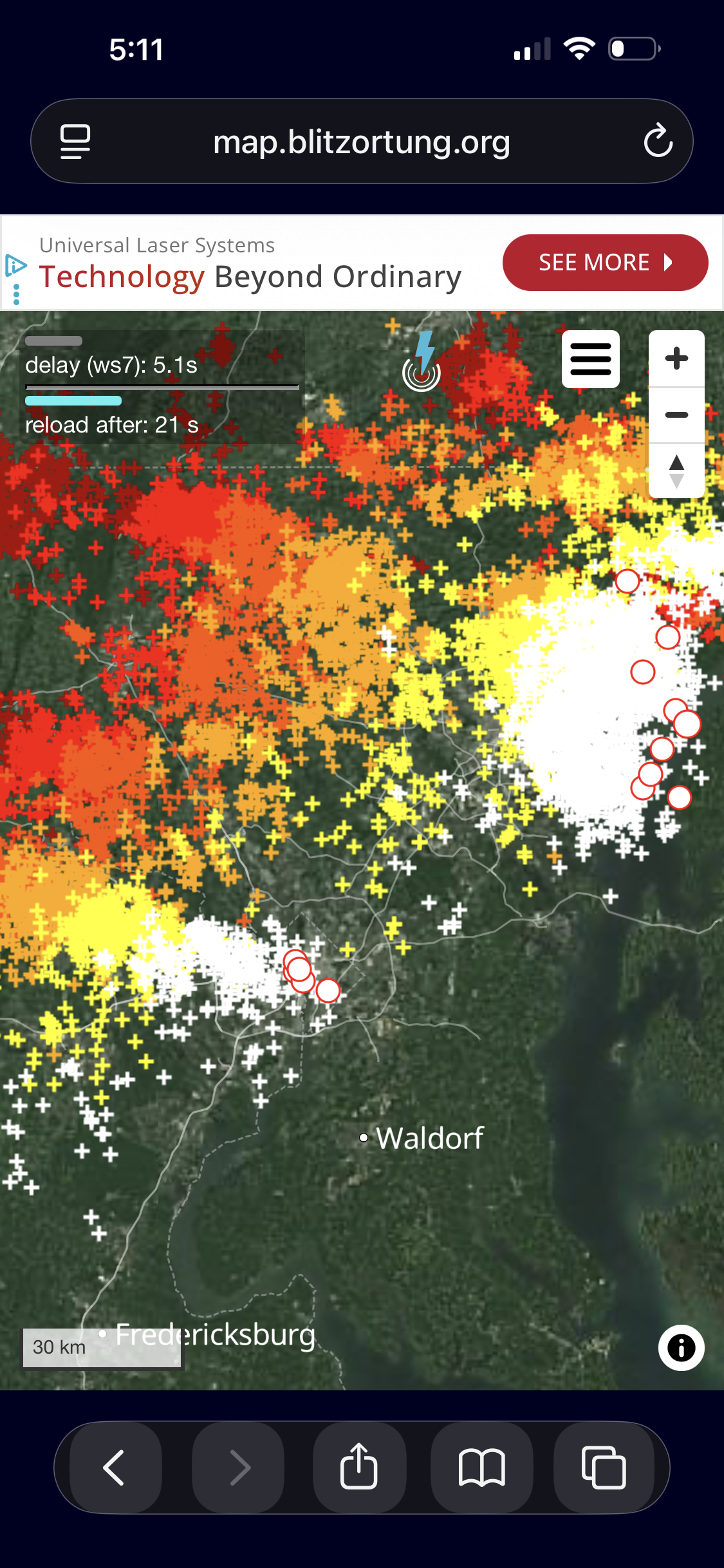
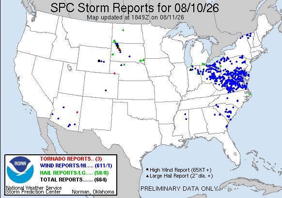
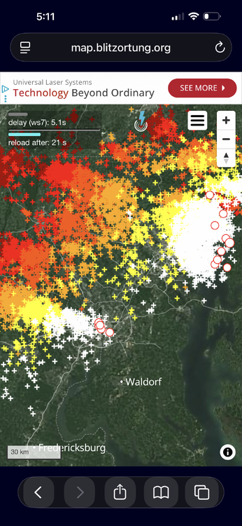
Yesterdays wind reports?...wow. You'd think it was a bona fide derecho! It wasn't, but the MCS areal coverage was very impressive NE to SW PA to VA. Also, the classic DC split occurred, at least for CGs. Take a look at the plot from later ydy. There was an uptick on CGs in downtown Silver Spring after the line moved through N side of the city. Saw some good CGs and heard some solid booming thunders to my S.
- 1,878 replies
-
- 3
-

-
- severe
- thunderstorms
- (and 7 more)
- Today
-
So far im pretty happy with this Kremer fella on the Twins. Two quality starts in the books
-
Yeah I would expect an EDS warning over a big tornado warning like that. Heavy rain here and maybe 55 mph wind thankfully. Lots of lightning.
-

2026-2027 Record-breaking El Nino
bluewave replied to Stormchaserchuck1's topic in Weather Forecasting and Discussion
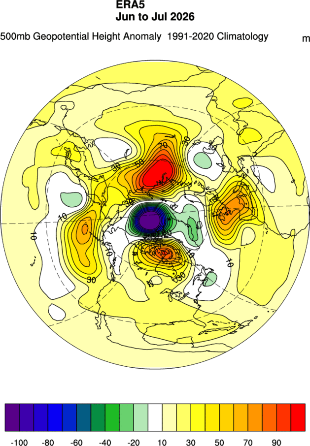
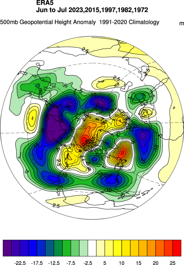
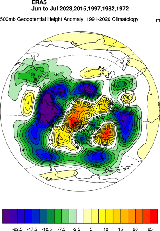
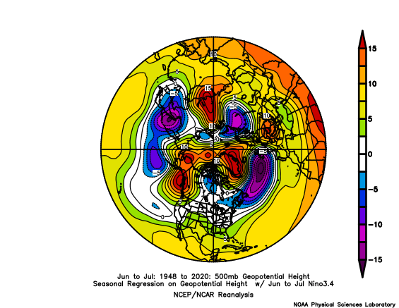
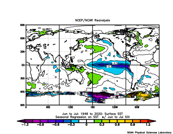
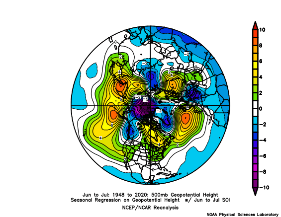
The 500 mb pattern during June and July across the Northern Hemisphere was the opposite of past developing super El Niño events. Had more in common with +SOI/ -PDO /La Niña June and July periods. Seasonsal forecast models from before the summer started missed this pattern.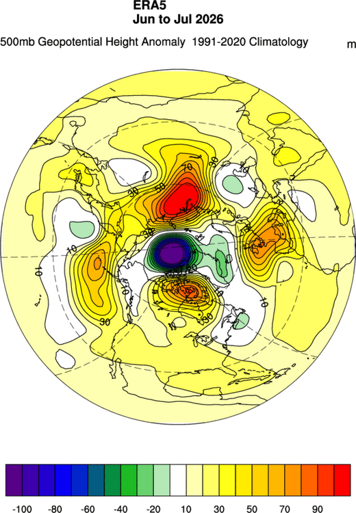
-
It's worse to our west (like WV). At least some sunshine has rebounded CAPE above 1000 in the metros seemingly. But still probably isn't going to do much. WV is devoid completely of CAPE
-

Occasional Thoughts on Climate Change
WolfStock1 replied to donsutherland1's topic in Climate Change
Re: Putin and Trump - that's politics, not science. Re: Observatories - these have *always* been in place high in the mountains, since long before CC became a thing. E.g. Mauna Kean in 1901, Kitt Peak in 1960, etc. Mountain air has *always* been known to be cleaner/clearer than seaside air since the beginning of time, and that has nothing to with CC. It's basic physics / meteorology, as well as where people live. It's actually the opposite of of what you claim - the reason why mountain air is so clear is ironically *because* for most people it's more desirable to live on the coast. So - perhaps try again with your reasoning. -
You guys been getting freight trqained
-

2026 Mid-Atlantic Severe Storm General Discussion
Eskimo Joe replied to Kmlwx's topic in Mid Atlantic
This probably will get classified as a derecho. Incredible stuff to witness today. One of the higher end wind events I've seen. -
Derecho before lunch, now sunny muggy skies
-

2026-2027 Record-breaking El Nino
LakePaste25 replied to Stormchaserchuck1's topic in Weather Forecasting and Discussion
Much of this depends on how much ocean heat is lost from the El Niño convection that’s occurring. In theory we run out of warm water to sustain El Niño in such conditions. It has to come from somewhere.