All Activity
- Past hour
-
National Weather Service Morristown TN 140 PM EST Sun Dec 28 2025 ...New DISCUSSION... .KEY MESSAGES... Updated at 1233 PM EST Sun Dec 28 2025 - Very warm this afternoon with possible record highs being broken again. - Showers and a strong cold front cross the area tonight and early Monday morning. - Strong gusty winds expected area-wide this afternoon through Monday, especially across the higher elevations tonight. Either Wind Advisories or a Special Weather Statement is in effect. - Much colder air moves in behind the front. Wind chills near zero are expected across the higher elevations Monday night, and highs in the 30s on Tuesday. && .DISCUSSION... Issued at 1233 PM EST Sun Dec 28 2025 One more day of well above average temperatures before a big pattern change beginning tonight. Low 70s are currently being reported across parts of the valley this afternoon already. Will include climate stats below. Daily Record High Maximum Temperatures: Date Chattanooga Knoxville Tri-Cities Oak Ridge 12-28 73(2015) 76(2015) 73(2021) 72(2021) Southerly to southwesterly winds are also occurring. Expect these to increase throughout the day and overnight tonight. A low center currently over Iowa and Illinois, will deepen through the day as it tracks towards the Great Lakes. A cold front will then develop and trail it to the southwest. Damming to the east under high pressure will kick-start the winds over the Southern Appalachians likely earlier than anywhere else because of increasing pressure gradient. This will not be a true mountain wave set-up for the Southern Appalachians given the flow direction with the frontal passage, but there will still be gusts to near 50 mph, as indicated by the Wind Advisory in place there. Wind Advisories were also added for the plateau and southwest Virginia counties. Upon looking at the latest guidance from HREF, RRFS, and others, winds appear they will generally remain below advisory level for the rest of the forecast area - valley and SW NC. A Special Weather Statement through Monday morning was issued there mentioning gusts up to 35 mph, with possible pockets of near 40 mph. After 7 am or so, winds will slowly decrease from west to east, but will hang on for the most part for the eastern higher terrain. The primary direction following the front will be from the west. The warmest temperatures tomorrow will likely occur near midnight for the forecast area, as the front makes its mark during the overnight hours. A line of showers will accompany the front, but the most we can expect are gusts translated down to the surface from aloft with any gusty showers. The strongest of any storms or severe weather threat, will remain close to the low`s center south of Michigan. It appears any influence of return- flow/northwesterly flow behind the low will remain to our north. With lows in the 20s and teens for the higher terrain forecast Tuesday morning and some winds persisting for the higher terrain as well, wind chills near 0 will be possible. Weather turns dry later tomorrow through Wednesday. High temperatures will rebound 10 degrees or so from Tuesday into Wednesday. A weak system will approach from the north Thursday into Friday, bringing a chance of light precipitation, with best chances across the northern part of the forecast area. By next weekend, precipitation chances increase from the south as the front stalls to our south. Where this sets up may determine how much precipitation we see. The southern valley and SW NC could sure use some beneficial rain to remove some of the moderate drought.
-

Ice Ice Baby December 28-29 Storm Discussion
UnitedWx replied to Baroclinic Zone's topic in New England
We've actually dropped a couple degrees the last couple hours. Down to 25 in Westfield. Hopefully the actual amount that falls isn't that great... but lighter seems to acrete more efficiently -
Its happened before with the AR out west during a NINA,buts its still more common with a NINO not NINA,it happened before in the winter of 2022-23
-

Ice Ice Baby December 28-29 Storm Discussion
Modfan2 replied to Baroclinic Zone's topic in New England
Down to 31F in E CT, only expecting a light glaze before we warm again -
This front tonight and tomorrow is going to be powerful. Real feel temps will differ almost 40 degrees from one end of the forum to another. According to the 18z 3kNAM, wind gusts could reach 40mph as the front passes through. The 18z HRRR, has gusts up to 50mph on the Plateau. Behind the front, on Monday and Tuesday wind chills very well could be in the single digits. Actual temps tomorrow night and Tuesday night should be in the mid teens to upper 20s. Winter is about to come back with a roar. The 3k Nam is picking up on some light snow bands as this passes in eastern areas. It doesn't have much accumulation, but it wouldn't surprise me to see the usual places at higher elevations get some light amounts.
-

Ice Ice Baby December 28-29 Storm Discussion
Damage In Tolland replied to Baroclinic Zone's topic in New England
What would say this was ? From 2 years ago . https://imgur.com/a/tAZcUAy#O9931d7 https://imgur.com/a/tAZcUAy#O9931d7 -

January 2026 regional war/obs/disco thread
CT Valley Snowman replied to Baroclinic Zone's topic in New England
I don't have access but I heard from the ENSO thread that the weeklies today were a solid look for the eastern US. -
Praying for your survival
-

Ice Ice Baby December 28-29 Storm Discussion
Redmorninglight replied to Baroclinic Zone's topic in New England
24 here in Thurman NY ADK park. 1800’. Up at the camp. Looks like we could see decent ice for a period. Glad my camp is off grid. Batteries at 90%. Beer fridge full. Be safe! . -

Ice Ice Baby December 28-29 Storm Discussion
ineedsnow replied to Baroclinic Zone's topic in New England
that was from 9am this morning.. but the 20z HRRR RAP and RRFS are interesting even for here.. just need the precip not go to far north or else we meh.. -
With the kind of wind expected, power outages become an inevitability for someone. I spent the afternoon tuning up my generator to assure it will stay on at DCL.
-

E PA/NJ/DE Winter 2025-26 Obs/Discussion
Ralph Wiggum replied to LVblizzard's topic in Philadelphia Region
Its like the snow at night-time...clockwork. Thats just how we do things. -

Ice Ice Baby December 28-29 Storm Discussion
dendrite replied to Baroclinic Zone's topic in New England
We deal with the overblown icing products every icing event. There will probably be spotty outages in the hill towns and here-north, but I’d be surprised at anything widespread. A half inch if accretion is a lot of ice. Heck this is only 5/16” radial.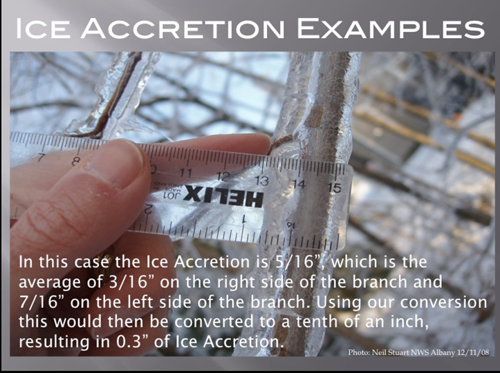
-

Central PA Winter 25/26 Discussion and Obs
Jns2183 replied to MAG5035's topic in Upstate New York/Pennsylvania
Because a day like this is a beer drinking day Sent from my SM-S731U using Tapatalk -
Plow just came by and salted road. No precip. falling. 28.6F
-

Central PA Winter 25/26 Discussion and Obs
canderson replied to MAG5035's topic in Upstate New York/Pennsylvania
We are at Troegs for dinner and it’s just a raw miserable day. But half of Hershey is here for some reason. -
this was a confirmed tornado in Illinois
-
I read that the severely cold 1917/18 winter produced such a freeze.i would have enjoyed listening to your grandfather and hearing how it was first hand. In the early to middle 50’s when I was in my single digits, sustained cold would result in broken ice flowing down the center of the narrows. (no bridge at that time) I guess it sourced from the southern extent of the frozen over Hudson River. As always …..
-
Bills fans will be unbearable again if that happens, lol Now, objectively for them...if they knock us out they'd better win it this year for their own sake--Mahomes is out of the way and they won't get a better shot! I hope they don't though, lol
-

MO/KS/AR/OK 2025-2026 Winter Discussion
stormdragonwx replied to stormdragonwx's topic in Central/Western States
Back to reality in Fayetteville. Went from 74 to 46 in an hour. -

Winter 2025-26 Medium/Long Range Discussion
Cary67 replied to michsnowfreak's topic in Lakes/Ohio Valley
Now vs late Nov.
-

Ice Ice Baby December 28-29 Storm Discussion
TheMainer replied to Baroclinic Zone's topic in New England
CAR is going with 2-4 here, up to an inch of sleet, and possibly 0.25 of freezing rain. I just hope by the time the rain gets here around 3-4pm we can Dryslot. Went and cut and packed our trails all open again today with the new snow after last Friday's wind and rain, honestly we're ready to groom, just need to have a bit of a net gain, even an inch or two would be huge -

Ice Ice Baby December 28-29 Storm Discussion
tamarack replied to Baroclinic Zone's topic in New England
Hoping for more IP, less ZR. Impressive diurnal range today, 30/-11. -
I know,i posted this in our severe thread earlier,its kinda like 2023
-

January 2026 regional war/obs/disco thread
CoastalWx replied to Baroclinic Zone's topic in New England
I mean, it’s January in Canada and you’ll have a ridge poking into Alaska. You don’t need a polar vortex over Hudson Bay.


