All Activity
- Past hour
-
Loud thunder just east of me now toward Afton...
-
-
As expected. 100s are very hard to come for most of us without the perfect conditions. In most scenarios you really need drought-like conditions to hit that century mark.
-
 The biggest issue with the change is that it only applies to organized severe, and we get quite a bit of disorganized severe. So microbursts fall outside of the scope of the outlooks.
 -
 Agreed. The more I dig into the changes and thought about it, the changes are a great positive. The number of moderate risk/high risk issuances should be reduced and only conserved for events that hold true significant and widespread potential. And for our area at least, we maybe get those type of setups with that potential maybe once every five years, if lucky. Probably closer to 1:7.
 -
Thanks for the term. I had never seen, or noticed, one in that posture but guessed why. I have more water out now. Hot enough in Pen Mar for panting chickens, ugh! Low 80, currently 94/76
-

Central PA Summer 2026 Discussion/Obs Thread
anotherman replied to Voyager's topic in Upstate New York/Pennsylvania
-
Payback for February.
-
94/71 feels like 102
-
95/64 as of 1PM.
-
It was probably the goal. But I do think widespread coverage of 45kt gusts probably doesn't deserve a moderate.
-
Pretty crazy how consistent it was so far out. And for it to verify also.
-

Central PA Summer 2026 Discussion/Obs Thread
Voyager replied to Voyager's topic in Upstate New York/Pennsylvania
The last two days we hit 90 before 10am. Today at 1pm were only at 89. I wonder how much last night's storm is playing into the slightly cooler temp today. -
I’m going to get a free air show from my backyard today as they line up to go over the length of the Mall.

-
1pm temps DCA 100 BWI 101 IAD 96 RIC 97 CHO 99 SBY 99
-

E PA/NJ/DE Summer 2026 Obs/Discussion
Birds~69 replied to PhiEaglesfan712's topic in Philadelphia Region
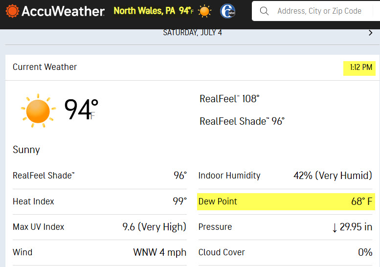
AccuWeather temp thing a little wonky. Went from 97F to 94F in 12 minutes...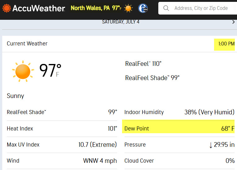
-
-
crazy to think a 45% sig 1 is still only an enhanced. We may never even see a moderate risk in our area again
-
Think Vegas is gonna outdo DC temps today…starting to get spicy again. Hopefully you all get some storms out of the heat wave, at least. Glad I moved my balcony furniture in…not doing so my last trip was not ideal.
-

Texas 2026 Discussion/Observations
BlizzardWx replied to Stx_Thunder's topic in Central/Western States
Certainly feeling like summer out there now. MCS expected tonight through the Tulsa area, but hopefully after fireworks. -
Just hit 100 again, 4 days in a row imby. Ashburn
-
If we avoid storms today, especially with the forecasted deluge in a couple days, it's really not going to be a big deal.
-
No records today, still sub-100 at 97.3
-
(002).thumb.png.6e3d9d46bca5fe41aab7a74871dd8af8.png) Happy 4th of July to all of you! Below is the history of July 4th weather since 1893 here in Chester County PA. Overall we have seen a flat trend in average temperature / a slight cooling trend for high temperatures and a slight warming trend for overnight low temperatures for the holiday. The hottest July 4th was back in 1966 the chilliest was in 1978.
Happy 4th of July to all of you! Below is the history of July 4th weather since 1893 here in Chester County PA. Overall we have seen a flat trend in average temperature / a slight cooling trend for high temperatures and a slight warming trend for overnight low temperatures for the holiday. The hottest July 4th was back in 1966 the chilliest was in 1978.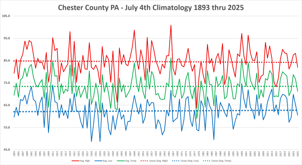
-
Updated 1730z SPC OTLK for Day 2 (tomorrow, Sunday) has added 5 hail and 30 wind Day 2 Convective Outlook NWS Storm Prediction Center Norman OK 1203 PM CDT Sat Jul 04 2026 Valid 051200Z - 061200Z ...THERE IS A SLIGHT RISK OF SEVERE THUNDERSTORMS ACROSS THE MID-ATLANTIC SUNDAY AFTERNOON AND EVENING... ...SUMMARY... Scattered wind damage is possible with thunderstorms across the Mid-Atlantic Sunday afternoon and evening. Isolated strong storms also are possible across Montana and western North Dakota, and portions of the southern Plains to the Tennessee Valley. ...Mid-Atlantic... A weak surface low is forecast to move west to east along a sagging cold front/baroclinic zone draped across PA into northern NJ/southeast NY on Sunday/Sunday evening. Meanwhile, lee troughing will develop across VA. A hot and very moist airmass will reside near and south of these boundaries, which will serve as a focus for severe storm development during the afternoon and into evening. Southwesterly flow aloft will weaken through the day as an upper shortwave impulse lifts northeast of the region, but around 20-30 kt mid/upper-level flow will persist. Moderate to strong destabilization is expected and thunderstorm clusters are expected by early to mid-afternoon. Sufficient clustering could occur along the southward-sagging cold front and one or more forward propagating clusters will be possible from northern VA into southeast PA until storms move offshore the Mid-Atlantic coast during the evening. Sufficient consistency among deterministic/CAMs and AI/ML guidance exists regarding storm coverage to warrant an upgrade to 30 percent wind probabilities for portions of the region.