All Activity
- Past hour
-
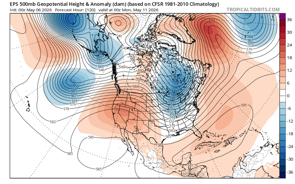
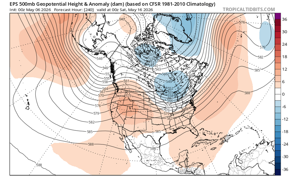
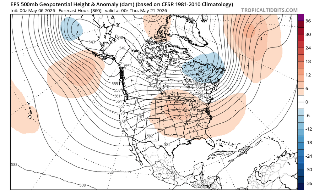
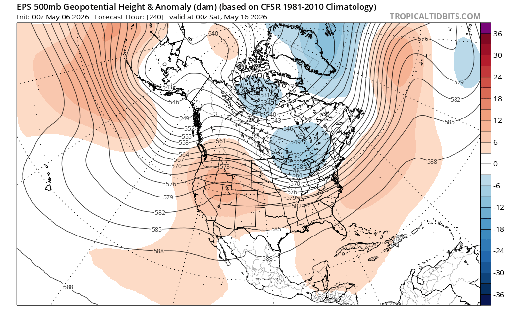
69 / 55 clouds / showers approaching from EPA. Looking like a general 0.25 or more for the area. Cooler Thu / Fri and perhaps a similar cloudy - showerish Saturday ahead of a one day Mothers Day warmup. Next week continues to look near / below normal with showers/rain on several days Mon - Fri. Still think we push towards a moderation by / after mid month with any shot at heat in the 5/17 - 5/24 window.
-
most of these rainy forecasts dont seem to pan out of late-look at today we'll be lucky to see .10 to maybe .25
-

2026 Spring/Summer Mountain Thread
Maggie Valley Steve replied to Buckethead's topic in Southeastern States
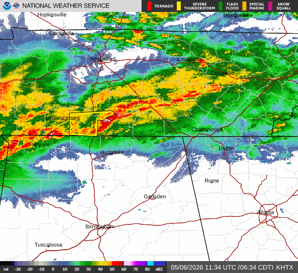
Light rain is falling over the Valley this morning. That radar looks very encouraging and I am hoping for an inch or two today and tonight! -
Really has continued to look like a widespread soaking is coming tonight/tomorrow. First time in forever it hasn’t collapsed up to this point. There’s still time to fail lol
-
(002).thumb.png.6e3d9d46bca5fe41aab7a74871dd8af8.png)
Central PA Spring 2026 Discussion/Obs Thread
ChescoWx replied to Voyager's topic in Upstate New York/Pennsylvania
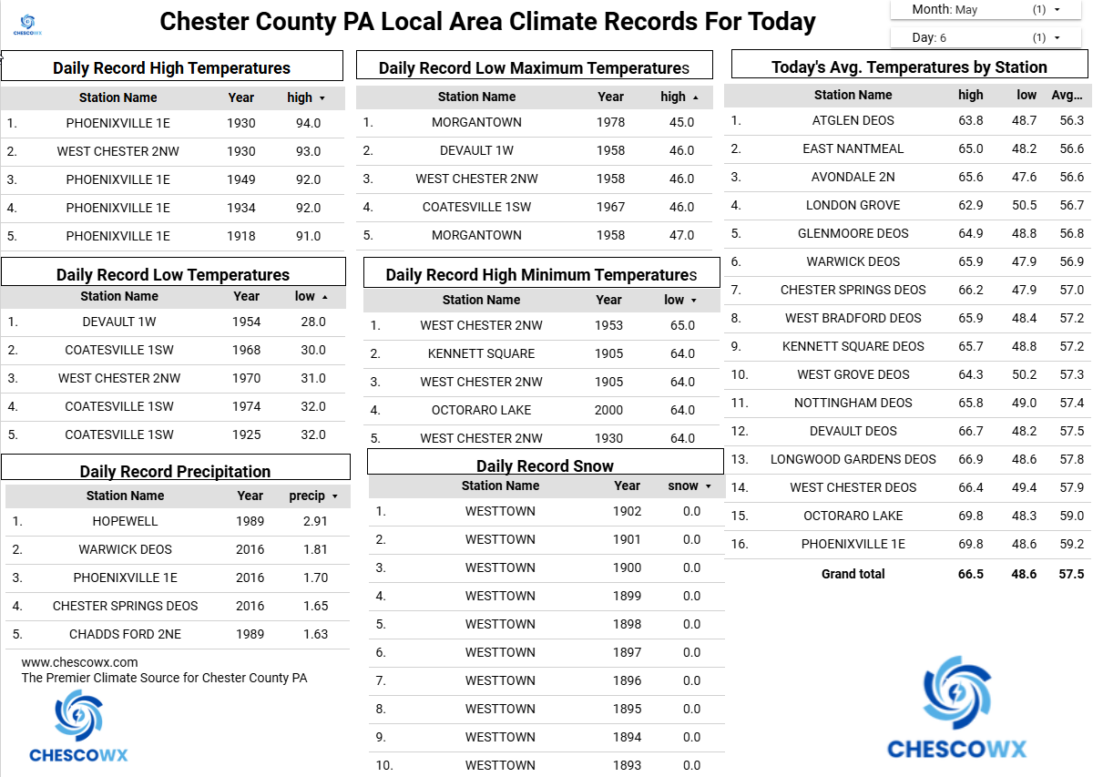
Cooler today with showers we could see up to 0.25" of needed rain. We are at 73% of normal rainfall for the year to date. We remain cooler than normal through Saturday with a brief warmup on Sunday to above normal before temperatures again fall below normal. Overall, the next couple weeks look to average below normal. Our next shower chances will be Saturday.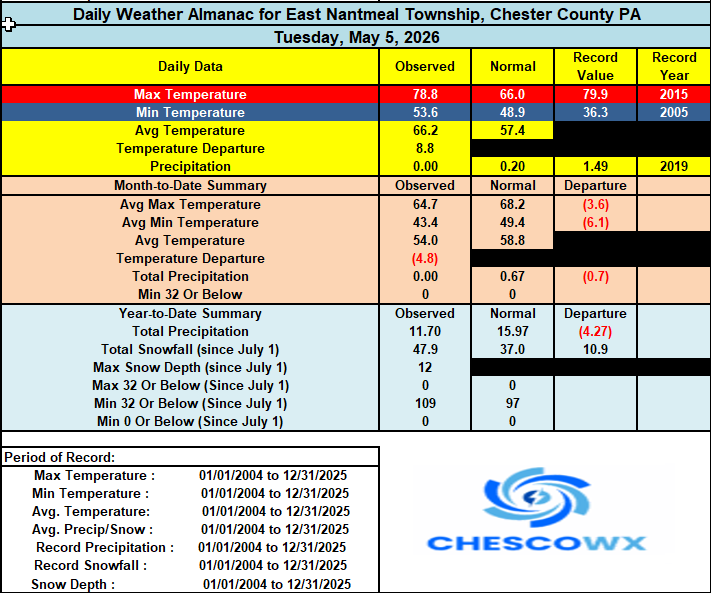
-
E PA/NJ/DE Spring 2026 Obs/Discussion
ChescoWx replied to PhiEaglesfan712's topic in Philadelphia Region
Cooler today with showers we could see up to 0.25" of needed rain. We are at 73% of normal rainfall for the year to date. We remain cooler than normal through Saturday with a brief warmup on Sunday to above normal before temperatures again fall below normal. Overall, the next couple weeks look to average below normal. Our next shower chances will be Saturday.
-
Interesting article ... scientists having pitted AI against SRES model systems. It inspires new research ideas for me where this could just be a start. But in so far as what it achieves, the basic finding is that AI is under-selling extreme events, performing demonstratively worse than standard physics-based SRES modelling - particularly with intensity handling. https://www.science.org/doi/10.1126/sciadv.aec1433
-
MSP got down to 32 this morning. Very likely our coldest morning until October.
-
Yeah we cool first half and then hopefully heat and dews after 20th or so.
-
Nice little rain event this morning! Only 0.01" in gauge at 7 am, but close to 0.10" since then with light rain continuing to fall. Currently 57.3/54.0.
-
This looks really good. Sent from my SM-G998U using Tapatalk
- Today
-
Looks like a fairly active pattern for cold fronts moving through from time to time. Main trough looks to be centered over the Great Lakes. It may continue to be the case that the NW winds behind the lows are more impressive than the actual rainfall totals. We’ll see… Perhaps as we approach late May the ridge out West can push into the Great Lakes and Northeast. But we would want to lose that 50/50 low to have a shot at some extended warmth like we had in March and April.
-
It almost feels like a snow day with how excited I am for rain tonight.
-
Another bustola for rain-maybe a quarter inch?
-

Central PA Spring 2026 Discussion/Obs Thread
Blizzard of 93 replied to Voyager's topic in Upstate New York/Pennsylvania
Good morning, any thoughts on when the rain should move out of the LSV today? We are supposed to have a softball game this evening in Perry county, but even if the rain ends this afternoon, field conditions might not be ideal. -
Glad I cut the lawn last night. Nice little rain. Will take every drop....
-
Coverage looks good, but intensity is relatively weak. Garrett Co looked like they were in a good spot and they have all of 0.15” per the mesonet.
-

2026-2027 Strong/Super El Nino
LakePaste25 replied to Stormchaserchuck1's topic in Weather Forecasting and Discussion
Your chart actually shows the flaws of MEI quite well. It’s only looking for one type/configuration of Nino. You can see how it significantly lagged the 2023-2024 Nino because of this. It may very well be true that the MEI will rate higher this time due to the +PMM, but you still have the -PDO working against it. -
sleep-deprived overnight warehouse shift, maybe he's hallucinated? Ineedsleep
-
But what to THE VIBEZ say about the rain??
-

Central PA Spring 2026 Discussion/Obs Thread
pawatch replied to Voyager's topic in Upstate New York/Pennsylvania
Wow radar is full today! 57 degrees…Stay dry! -
Almost 7" accumulated, but only 3" overnight, which was supposed to be the bulk of the storm. We'll see what this last wave brings this morning, if anything.
-
How are your sweat pores holding up this morning?
-
You stole my comment lol. Radar looks better than I expected.


.thumb.gif.f92b16c631a1d15d405ed77b33f0710d.gif)


