All Activity
- Past hour
-
June 14 1981: A tornado hits Roseville, destroying homes and damages Har Mar Mall. Note: This was an EF-3. Story here: https://www.dnr.state.mn.us/climate/journal/tornado19810614.html 1956: 8 inches of rain fall in the Ivanhoe area in 3.5 hours. 100 thousand dollars in damage to crops is reported. 1943: Torrential downpours cause flooding in the Twin Cities and east central Minnesota. 2.5 inches of rain fall in St. Paul in two hours. In addition, four streetcars are hit by lightning. For Sunday, June 14, 2026 1903 - The Heppner Disaster occurred in Oregon. A cloudburst in the hills sent a flood down Willow Creek, and a twenty foot wall of water swept away a third of the town in minutes, killing 236 residents and causing 100 million dollars damage. (David Ludlum) 1961 - The temperature in Downtown San Francisco, CA, soared to 106 degrees to establish an all-time record for that location. (The Weather Channel) 1987 - Thirty-two cities in the central U.S. reported record high temperatures for the date. The high of 97 degrees at Flint, MI, tied their record for June, and the high of 101 at Milwaukee WI marked their first 100 degree reading in 32 years. Thunderstorms brought much needed rains to South Texas, drenching McAllen with 3.2 inches in one hour. A thunderstorm soaked the town of Uncertain with 2.3 inches of rain in one hour. (The National Weather Summary) 1988 - Thirty cities in the eastern U.S. reported record high temperatures for the date. (The National Weather Summary) 1989 - Thunderstorms developing ahead of a cold front produced severe weather from the Central Gulf States to the Middle Atlantic Coast Region during the day and into the night. There were 62 reports of large hail and damaging winds. Thunderstorm winds caused 28 million dollars damage in Montgomery County MD. (Storm Data) (The National Weather Summary) Observances: 14 Sun Bourbon Day 14 Sun Odunde Festival 14 Sun National Children’s Day 14 Sun World Blood Donor Day 14 Sun Army Birthday 14 Sun Flag Day 14 Sun International Bath Day 14 Sun Monkey Around Day 14 Sun National Bourbon Day 14 Sun National New Mexico Day 14 Sun National Pop Goes The Weasel Day 14 Sun National Strawberry Shortcake Day
-
Better support today. Much more shear. I think it'll arrive earlier, closer to 8-9
-
Heard my first katydid this morning. Always reminds me of my grandmother. Like a lot of mountain people, she was always reciting folklore. One of them was that 16 weeks from the first katydid singing in the mountains of SC would be the first frost. It actually always works out pretty close…
-
Cloudy most of yesterday with highs in the 60's. 40's this morning. Might hit 70 today if the sun stays out. Red Flag warning out as well.
-
The afternoon and early evening looks dry. Timing for the storms looks late -- maybe not until between 10 and midnight. Hopefully it won't weaken too much by then.
-
It's certainly intriguing for sure, especially given the shear forecast. If we aren't going to get steep mlvl lapse rates then hopefully we can get dewpoints into the lower 70's and at least increase potential to push MLCAPE values ~2000 J. Too early to really worry about CAPE potential but if we can muster 1500-2000 J of MLCAPE in this environment, there would be some nasty storms for sure.
-
(002).thumb.png.6e3d9d46bca5fe41aab7a74871dd8af8.png)
Central PA Summer 2026 Discussion/Obs Thread
ChescoWx replied to Voyager's topic in Upstate New York/Pennsylvania
Much more humid today before a strong cold front crosses later this evening. The best chances for thunderstorms and rain will be between 8pm and 11pm across the area. Tomorrow and Tuesday will feature much cooler weather with highs only in the low to mid 70's with night well down into the 50's with 40's possible in our usually colder valley locations. We briefly warm again toward Thursday before we turn cooler for next weekend.
-
E PA/NJ/DE Summer 2026 Obs/Discussion
ChescoWx replied to PhiEaglesfan712's topic in Philadelphia Region
Much more humid today before a strong cold front crosses later this evening. The best chances for thunderstorms and rain will be between 8pm and 11pm across the area. Tomorrow and Tuesday will feature much cooler weather with highs only in the low to mid 70's with night well down into the 50's with 40's possible in our usually colder valley locations. We briefly warm again toward Thursday before we turn cooler for next weekend.
-
Hard to get the heat and humidity to hit and hold so far this warm season. It gets hot and humid for a short stretch and then it is broken but a nice air mass. No complaints from me. I had been forecasting the heat to return and hold by the end of the coming week but once again it is delayed. We'll see what the closing 7 days of June bring and then into July. Just need some rain. The long term dryness still shows no sign of breaking. We'll see who gets what later today. Was initially thinking the 7 day period ending this coming Wednesday would have been wetter with 1-2" totals fairly widespread but it is under performing. The heaviest rains have stayed west from the Mississippi River to just west of the Appalachians.
-
Amazing photos as always Don. Really beautiful!
-
HRRR is nice for overnight tonight. 3km NAM blows.
-

2026-2027 Super El Nino
buckeye replied to Stormchaserchuck1's topic in Weather Forecasting and Discussion
Yea, clickbait, just thought the headline was so opposite this thread, I couldn’t resist - Today
-
Records: Highs: EWR: 99 (1988) NYC: 99 (1956) LGA: 99 (1956) JFK: 95 (2005) Lows: EWR: 49 (1978) NYC: 49 (1875) LGA: 51 (1978) JFK: 52 (1980) HIstorical: 1886: Many people were lost when high seas from a hurricane inundated the area near Sabine, TX. (Ref. Wilson Wx. History) 1887: Lexington and Long Creek, Oregon: First documented Oregon tornadoes strike Lexington in Morrow County and Long Creek in Grant County, causing considerable damage to farmland and timber. In addition, the Lexington tornado results in one death, the only one ever reported from a tornado in Oregon. 1903 - The Heppner Disaster occurred in Oregon. A cloudburst in the hills sent a flood down Willow Creek, and a twenty foot wall of water swept away a third of the town in minutes, killing 236 residents and causing 100 million dollars damage. (David Ludlum) 1953: The warmest June on record occurred in Oklahoma City, OK. The main part of the heat wave extended from the 11th through the 21st, and seven of the daily high temperatures during that stretch remain records for their respective dates. June 14th was the hottest day, reaching a toasty 106°. The other records ranged from 100° to 105°. Even the nighttime lows were records. Eight daily minimum temperatures from June 1953 are still record-warm daily minimum temperatures, ranging from 75° to 80°. (Ref. Wilson Wx. History) 1957: An F4 tornado moved across the south and southeast sides of Springfield, IL. The tornado destroyed 25 homes and severely damaged 175 others; property damage was around $3 million dollars. On the north side of town, the storms produced a wind gust of 98 mph at Capital Airport, which still stands as Springfield's record wind speed. Two people died during the storm, with over 50 others injured. A separate tornado touched down in downtown Jacksonville, destroying or damaging 40 buildings. East St. Louis, IL recorded the state record for rainfall in 24 hours with 16.54 inches. (Ref. Wilson Wx. History) 1961 - The temperature in Downtown San Francisco, CA, soared to 106 degrees to establish an all-time record for that location. (The Weather Channel) 1974: A tornado took an intermittent 53 mile long path across northwest and west central Illinois. The tornado first touched down just southeast of the Quad Cities, and moved southeast into Knox County. In Abingdon, 200 homes were damaged or destroyed. (Ref. Wilson Wx. History) 1987 - Thirty-two cities in the central U.S. reported record high temperatures for the date. The high of 97 degrees at Flint, MI, tied their record for June, and the high of 101 at Milwaukee WI marked their first 100 degree reading in 32 years. Thunderstorms brought much needed rains to South Texas, drenching McAllen with 3.2 inches in one hour. A thunderstorm soaked the town of Uncertain with 2.3 inches of rain in one hour. (The National Weather Summary) 1988 - Thirty cities in the eastern U.S. reported record high temperatures for the date. (The National Weather Summary) 1989 - Thunderstorms developing ahead of a cold front produced severe weather from the Central Gulf States to the Middle Atlantic Coast Region during the day and into the night. There were 62 reports of large hail and damaging winds. Thunderstorm winds caused 28 million dollars damage in Montgomery County MD. (Storm Data) (The National Weather Summary) 1990: Shadyside, OH was destroyed by a wall of water up to 30 feet high causing 26 fatalities. The flooding was caused by 4 inches of rain that fell in just 75 minutes. Localized, excessive rainfall fell on saturated ground over southeastern Ohio during the evening, resulting in a 15 to 20 foot wall of water that raced down three small tributaries of the Ohio River. (Ref. Wilson Wx. History) 1994: Norfolk: a bolt of lightning struck and critically injured a 50-year-old woman and a 38-year-old man playing in a golf tournament at Greenbrier Country Club in . Both suffered severe burns. 1998: On June13th and 14th Boston, MA had 5.99 inches precipitation the greatest in a 24 hours for June. (Ref. NOAA Boston Weather Events) and Atlantic, Iowa, set a state record for daily precipitation, measuring 13.18 inches of rain. (Ref. Wilson Wx. History) 2000: Rockingham County, three dispatchers were shocked through their headsets by a lightning strike. (Ref. Lightning - Virginia Weather History) 2001: Heavy wet snow fell along the Beartooth foothills in Montana. Snowfall totals included: 24 inches 9 miles south of McLeod, 18 inches just west and south of Red Lodge, McLeod & Mystic Lake: 12 inches, Stillwater Mine: 6 inches and Red Lodge: 1 inch. (Ref. Wilson Wx. History) 2009: The line of severe thunderstorms formed along a boundary over the western suburbs of Denver, CO then moved east. The boundary produced at least one well defined funnel cloud that was observed by a stadium full of baseball fans at Coors Field. Large hail up to 1.75 inches in diameter was reported at Arvada, Broomfield, Denver, Federal Heights and North Glenn. In addition, the storm produced wind gusts from 60 to 74 mph. A peak gust of 58 mph was observed at Denver International Airport. (Ref. Wilson Wx. History) 2010: During June 14, training thunderstorms associated with a nearly-stationary cold front and an intense low-level jet brought torrential rains to the Oklahoma City, Oklahoma, area. Six to nine inches of rain in little more than three hours caused flash floods, resulting in more than three dozen water rescues. The North Canadian River at Oklahoma City rose from eight feet to over 21 feet almost instantly during the morning of June 14, Oklahoma City's wettest day on record (7.62 inches).
-
49 and cloudy with some light showers this morning. High should reach the upper 50's with a stout nw'trly breeze. Good day for a deep woods hike, bugs will be minimal.
-
Warm start to the day. Mid 80s already.
-
80 / 61 sunny but clouds already to CPA and suspect much of the afternoon is more clouds than sun but still upper 80s - low 90s (extending the heatwave for those that hit 90 on saturday). Front and some storms later this evening and overnight could be some strong to severe storms. Cooler Mon - Wed, brief heat spike Thu more 90s then quickly followed by cold front Friday. Ridge west - trough easy and overall near normal through the 24th. Last week of the month ahead of and into next should see more above normal biuld in and next chance of multi 90 degree days or sustained heat. 6/14 : Hot / storms 6/15 - 6/17 : Cool / dry very nice days 6/18: Brief heat spike 6/19 - 6/24 : Ridge west / trough northeast - near normal limited if any 90s 6/25 - beyond : Moderation to warmer - next chance and heat towards the end of the period and opening next month
-
-

2026 Mid-Atlantic Severe Storm General Discussion
high risk replied to Kmlwx's topic in Mid Atlantic
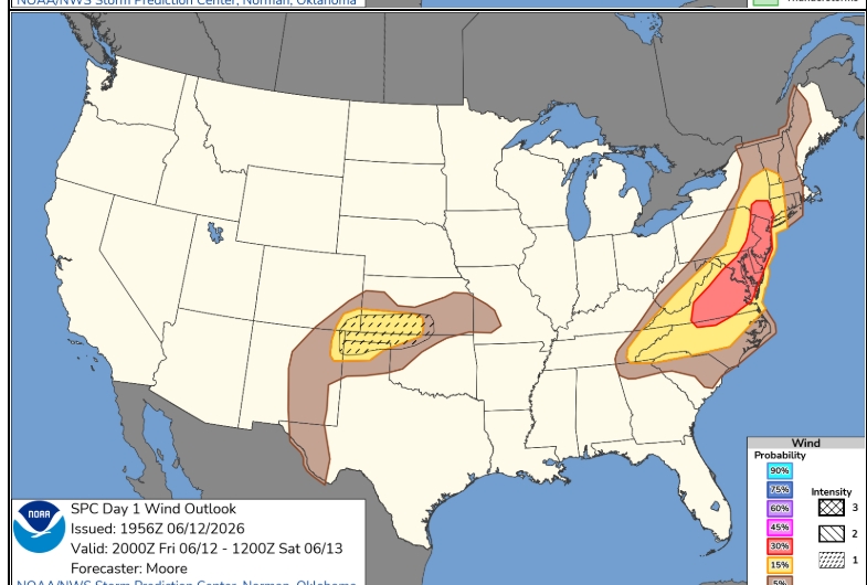
The synoptics definitely scream big event for someone, but the sounding you showed highlights the possible fail mechanism here. The strong mid-level flow develops a sharp lee trough on the east side of the Appalachians early in the day which blasts across the Mid-Atlantic by lunchtime. We then downslope big time ahead of the cold front. That's why there is no directional shear in that sounding - the low-level flow has shifted to westerly. Still plenty of time for sure, though, to sort out the synoptic details. -
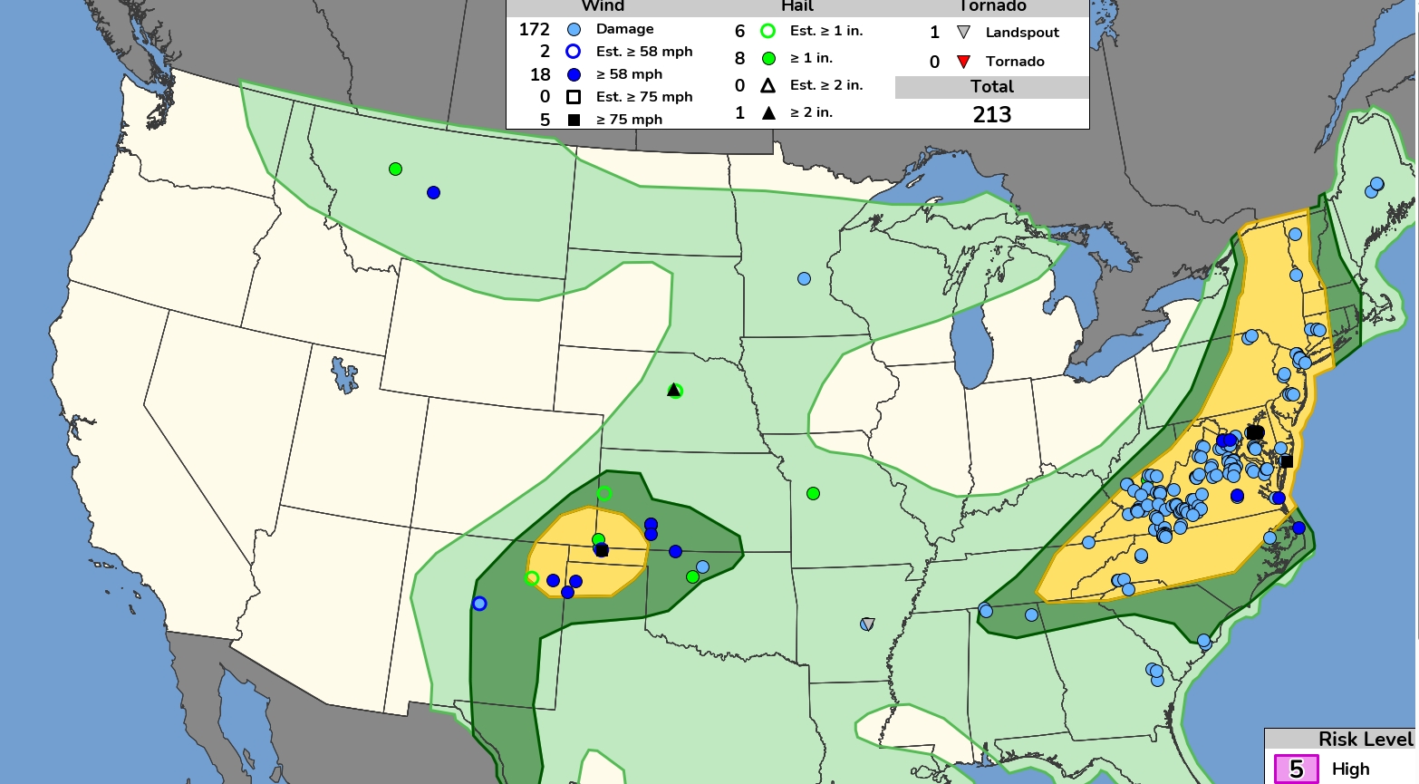
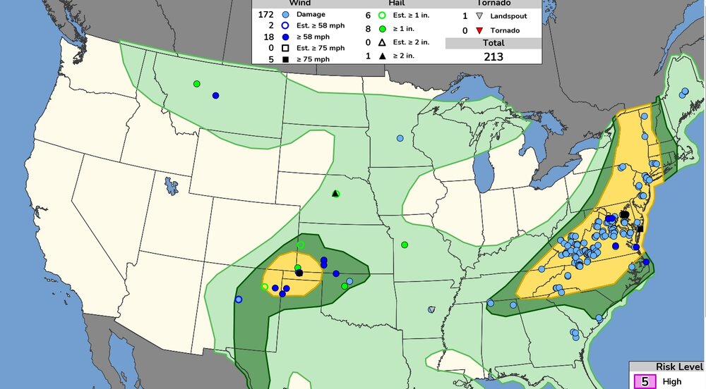
Somewhat debatable depending upon who you ask. I have seen some strange things over the years. One might expect more reports in central NC from a DAY One forecast for Slight Risk from SPC----which had changed much with updates. With that said, there was not a Watch Issuance in NC, but one was issued for parts of VA, and the border counties of northwestern NC. Here is a preliminary verification map. Maybe not terrible, but like I said, one maybe would have expected at least a few reports in central NC----regardless of any watch. That's weather for you. SPC Severe Weather Event Review for Friday June 12, 2026.
-
Some form of a severe threat, or just some weird anachronistic cyclone for this time of year with a lot of wind Thursday Emerging yet still vague heat signal after the 25th
-
2026 Mid-Atlantic Severe Storm General Discussion
high risk replied to Kmlwx's topic in Mid Atlantic
I'm still pretty bullish on today, especially for those east of Route 15. I'll be watching dew point this afternoon closely, as a number of models really mix out for a while and lower the dews significantly. That said, I'm not sure that I buy it to the extent that some guidance has most guidance recovers moisture ahead of development, and shear will be very good later today. If moisture really does mix out for a while, the threat will then be more focused east of the Potomac.- 669 replies
-
- 6
-

-
- severe
- thunderstorms
- (and 7 more)
-
A surprise storm came through this morning dumping a quarter inch, wish I didn't run my sprinkler at 4am. Sun is coming out. Steamy already. Nascar at 1 while floating in the pool today!
-
Beautiful morning here. 58.0 for the low, currently 62.0/58.0 at 8:40 am with partly cloudy skies.
-

Central PA Summer 2026 Discussion/Obs Thread
Mount Joy Snowman replied to Voyager's topic in Upstate New York/Pennsylvania
Low of 65. Looks like any real action down this way may not occur until after sundown. Then comes the relief, setting up a beautiful couple of days. -
Could be a decent storm day. Looks like could put a damper on the White House ufc event lol
- 669 replies
-
- 2
-

-

-
- severe
- thunderstorms
- (and 7 more)