All Activity
- Past hour
-
Os got decent pitching, timely hitting, and didn't have costly defensive/ base running gaffes. Solid game by O'Neill(need way more of that) And they won. Imagine that.
-
 meh that's a lot of money to look at clouds and put things out on auto
 -

E PA/NJ/DE Summer 2026 Obs/Discussion
Hurricane Agnes replied to PhiEaglesfan712's topic in Philadelphia Region
Looks like after multiple attempts to go higher, I pretty much hit 95 as a high for today. Since I only reached 89 for a high yesterday, today starts my heatwave clock. Currently HHH with a bit of a breeze and 93, with a ridiculous dp of 80 (weather station has a "feels like" of 112). -
 @dendrite ASOS has been down at BDL since last Thursday morning. Screen just says "NO CARRIER" and we were directed by FAA to just let obs go out on AUTO.
 -
 Good, actionable info. A lot of anecdotal comments going around without nuance… obviously everyone’s mileage will vary.
 -
Yeah I bet the neighborhood is bustling at -25F. I love the cold and spend most time outside on the mountain in it, but it’s a fools errand to say more folks are outside in extreme cold than extreme heat. Plenty of folks out up here.
-
Made it to 94 here. Which is hot for mby. I can't remember if I even made it over 90 last summer.
-
 Such a cool spot.
 -
82/73 Max of only 84.4
-

2026-2027 Super El Nino
forkyfork replied to Stormchaserchuck1's topic in Weather Forecasting and Discussion
-

Central PA Summer 2026 Discussion/Obs Thread
canderson replied to Voyager's topic in Upstate New York/Pennsylvania
101 at 4:40 -
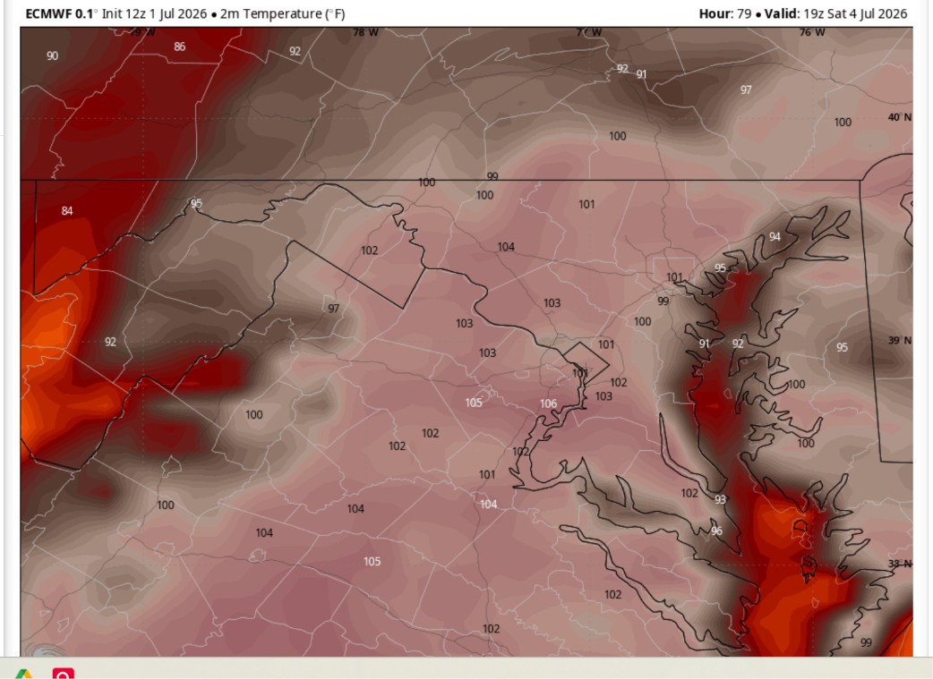
 I see a diaster in the makings. Not political this would happen no matter what administration but.... 3pm Euro temp's on July 4th in DC. Severe thunderstorm potential too. For security no umbrellas allowed on the National Mall. No shade. No shelter. No place to run for severe weather. What could go wrong?
-
99
-

Central PA Summer 2026 Discussion/Obs Thread
CarlislePaWx replied to Voyager's topic in Upstate New York/Pennsylvania
Here in Carlisle at 4:30pm...the temperature has cracked the century mark, no sitting at 100.4 degrees. The dew point is 78.4 degrees while the heat index is a potentially deadly 119.5 degrees. This is the hottest temperature in more than 2 years. What else can I say? I'll be back with another update probably in an hour. -
 90/77
90/77 -
91.8 for the high at both my stations today.
-
 No worrying about track, banding, or ratios. Just large scale WAA up thy fanny.
 -

Central PA Summer 2026 Discussion/Obs Thread
Voyager replied to Voyager's topic in Upstate New York/Pennsylvania
I might have to go into the witness protection program after posting this...
-
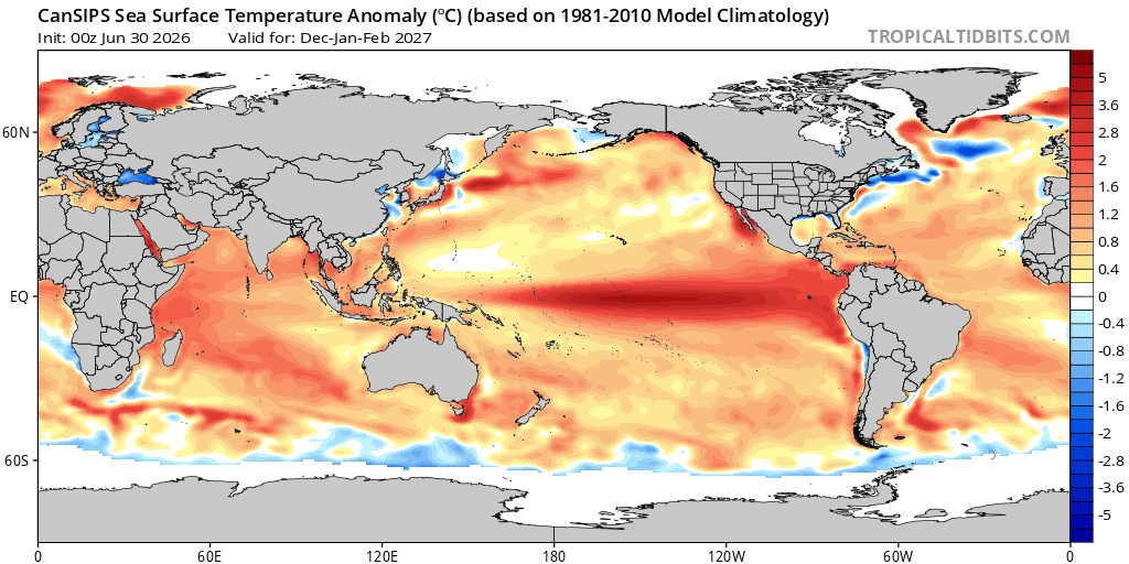
CanSIPS has a basin wide Nino for the winter months. If that verifies the chances for snow vs mostly rain will largely be determined by the HL pattern. As currently advertised the h5 look(+PNA/-EPO/ possibly -AO/NAO should bring some colder air southward at times to combine with a pronounced STJ and some favorable storm tracks. All speculation at this juncture ofc. I will 100% roll with that idea. Anything but a strong East-based event.
-
98 75dp 112 hi in sunny SE. A cracking 101 on my porch in the shade
-
95/106
-
Simply magical weather . It truly is
-

E PA/NJ/DE Summer 2026 Obs/Discussion
MGorse replied to PhiEaglesfan712's topic in Philadelphia Region
It is rather toasty out! Heat index here is 108F! -
One record to watch for RDU (and likely other sites) is the record for longest consecutive streak of 100+ degree highs. Current record from 2012 is 6 days. NWS is forecasting 5 straight 100+ days at the moment (100, 102, 102, 103, 100) but Tuesdays high will be dang close at 98 (and we know 2 degrees above forecast is just a casual Tuesday for the RDU sensor).
-
Alot of local stations at 100 near me. Frank, what are you at? I know you are in Aruba but still lurking.