
All Activity
- Past hour
-
Qdoba > Chipotle
-

2026-2027 Record-breaking El Nino
40/70 Benchmark replied to Stormchaserchuck1's topic in Weather Forecasting and Discussion
Yea, I get it's too early to definitely say whether that will chance by the time that the winter season ensues, but the mid latitude ground truth relative to the development of past major El Nio events dictates that this definitely remains a work on progress. -

Central PA Summer 2026 Discussion/Obs Thread
mahantango#1 replied to Voyager's topic in Upstate New York/Pennsylvania
Flood Watch National Weather Service State College PA 1214 PM EDT Thu Aug 20 2026 PAZ012-041-042-045-046-049>053-057>059-065-066-210000- /O.EXB.KCTP.FA.A.0013.000000T0000Z-260821T0000Z/ /00000.0.ER.000000T0000Z.000000T0000Z.000000T0000Z.OO/ Northern Clinton-Northern Lycoming-Sullivan-Southern Clinton- Southern Lycoming-Union-Snyder-Montour-Northumberland-Columbia- Dauphin-Schuylkill-Lebanon-York-Lancaster- Including the cities of Lock Haven, Shamokin, Renovo, Williamsport, Selinsgrove, Harrisburg, Danville, Pottsville, Hershey, Bloomsburg, Berwick, Sunbury, York, Lebanon, Trout Run, Lewisburg, Laporte, and Lancaster 1214 PM EDT Thu Aug 20 2026 ...FLOOD WATCH IN EFFECT UNTIL 8 PM EDT THIS EVENING... * WHAT...Flash flooding caused by excessive rainfall continues to be possible. * WHERE...A portion of central Pennsylvania, including the following areas, Columbia, Dauphin, Lancaster, Lebanon, Montour, Northern Clinton, Northern Lycoming, Northumberland, Schuylkill, Snyder, Southern Clinton, Southern Lycoming, Sullivan, Union and York. * WHEN...Until 8 PM EDT this evening. * IMPACTS...Excessive runoff may result in flooding of rivers, creeks, streams, and other low-lying and flood-prone locations. Creeks and streams may rise out of their banks. Flooding may occur in poor drainage and urban areas. * ADDITIONAL DETAILS... - Periods of heavy rain are expected this afternoon through the evening. Rainfall amounts up to 3 inches are possible. - http://www.weather.gov/safety/flood -

Augdewst 2026: Summer's Last Stand
Brian5671 replied to Prismshine Productions's topic in New England
New GFS keeps most of it south of all of us Saturday -
Hopefully, the guidance will be accurate and the heaviest rains will avoid your area and others that have recently experienced flooding.
-

2026-2027 Record-breaking El Nino
Typhoon Tip replied to Stormchaserchuck1's topic in Weather Forecasting and Discussion
Need the return of hemispheric seasonal gradient increase - the triggered machinery response ( wave spacing and speeds and jet location biases ..et all) will be conducted by the new maestro so to speak. Prior to that, all we have is WWBs and vague SS stressing differentiating SST pattern/morphology, happening amid a generic summer hemisphere that remains unresponsive. The gradient and the response/forcing of planetary wave modes come hand in hand -

2026 Mid-Atlantic Severe Storm General Discussion
ravensrule replied to Kmlwx's topic in Mid Atlantic
Are you at Chipotle?- 2,024 replies
-
- 1
-

-
- severe
- thunderstorms
- (and 7 more)
-
Feeling FAIRLY confident that my area of NW NJ will escape the heaviest event totals. Guidance has been targeting mainly along and east of I95 for max totals. Will have to watch radar over the next several hours. Key for NW NJ is where downstream convection starts to "ignite". Hopefully it will be near or east of BWI/PHL and then lift and/or train NE leaving NW NJ with just more frontal related rainfall but still with heavy downpours. Can deal with 1 or 2" out this way but 3-5" totals not good for this area. Still very wet out my way. Sitting at 5.5" for August to date here.
-
 best payday advance loans online: CashBridgeConnect - get payday loan online today
 -
What a time to be alive
-

Augdewst 2026: Summer's Last Stand
weatherwiz replied to Prismshine Productions's topic in New England
Looks like Hawaii dodging a bullet with Two-C -
The August 20, 2026 12z HREF:
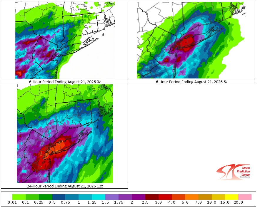
-

E PA/NJ/DE Summer 2026 Obs/Discussion
RedSky replied to PhiEaglesfan712's topic in Philadelphia Region
Drought buster incoming -
Augdewst 2026: Summer's Last Stand
weatherwiz replied to Prismshine Productions's topic in New England
Very tough forecast. Definitely better potential for more in the way of consistent rain eastern CT and points east, particularly on Saturday. Sunday I don't think is a rain all day but there could be some room for some strong storms and downpours in the afternoon if we destabilize enough. Saturday could be like EOR type ordeal and Sunday WOR -

Augdewst 2026: Summer's Last Stand
Chrisrotary12 replied to Prismshine Productions's topic in New England
We’re #1. We’re #1. We’re #1! -
Crapvection around now
-

Augdewst 2026: Summer's Last Stand
Ginx snewx replied to Prismshine Productions's topic in New England
Shit weather incoming. Damn it. Hopefully doesn't rain all weekend. -
2026-2027 Record-breaking El Nino
40/70 Benchmark replied to Stormchaserchuck1's topic in Weather Forecasting and Discussion
It seems to me like we are establishing a modest cool ENSO baseline of sorts due to the increased warmth pooling in the western Pacific, however, for that same reason the frequency of powerful El Nino events is also increasing as part or the overall redistribution oriented efforts to maintain the global heat budget.....ie more frequent La Nina, but weaker...less frequent El Nino, but more powerful ones. -
A refresher on the way.
-
I've had lots of rain in Currituck NC the past few weeks. Mowed yesterday afternoon but ground still saturated. However, it doesn't take much for my particular location to stay wet for a long time since I'm only about 4 ft above sea level. Looking at another soaking the next 3 days.
-
hi-res baby canuck been having a summer
-
secret on our wonderful region very much out these days
-

2026-2027 Record-breaking El Nino
Maestrobjwa replied to Stormchaserchuck1's topic in Weather Forecasting and Discussion
And here I eas thinking we were going the opposite way with the perpetual nina we've had...I mean one double nina and one triple dip in the last 6 years has just been dumb, lol -
Agreed. Fantastic AFD. The team at LWX is top notch.
- 2,024 replies
-
- 1
-

-
- severe
- thunderstorms
- (and 7 more)
-
And Christmas 1965: 69hi Notice what happened later in the winter after the three Christmases we hit 69 or 70...lol Big blizzard! So maybe that'll be the tell this year...69-70 or above on Christmas day--we snow later 60 or below? No go...while I don't like warm Christmases I will happily take one in exchange!








