All Activity
- Past hour
-
Probably... but to me thats "good news" for our severe prospects IMO. Granted we could still whiff, but 80% chance of a watch box to our north suggests to me that we are definitely in the game this afternoon for severe
-
It looked like you were at least going to get a decent rain over there. I guess that didn’t happen. We ended up with about .60 here last night. I wasn’t sure we were going to get anything so I’m happy with that.
-

2026 Mid-Atlantic Severe Storm General Discussion
Eskimo Joe replied to Kmlwx's topic in Mid Atlantic
^looks like an I-70 and north kind of watch box -
 crazy rain in westfield https://www.westfieldwebcam.com/
 -
 .46 already here in Enfield.
 -
he wasn't wrong with what he said.. and trust me far from left but lets stick to weather
-
 You’re laughing along with a strong leftist in those posts. In case you didn’t know
 -

Central PA Summer 2026 Discussion/Obs Thread
mahantango#1 replied to Voyager's topic in Upstate New York/Pennsylvania
Sun has been out now almost a half hour here. -

2026-2027 Super El Nino
bluewave replied to Stormchaserchuck1's topic in Weather Forecasting and Discussion
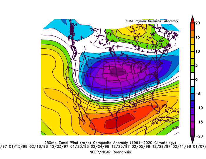
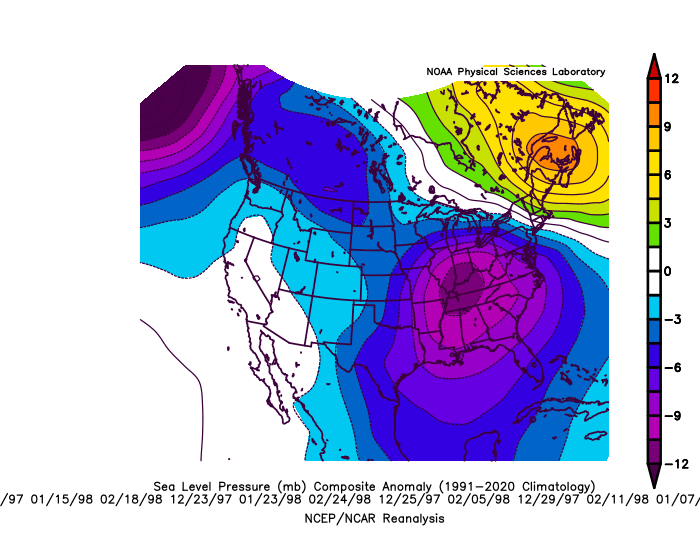
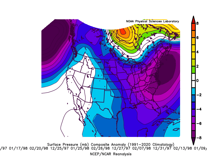
1997-1998 was a great example of what happens when the STJ overpowers the pattern with too much warmth. NYC only finished with 5.5 inches of snow that season. Many lows running to the Ohio Valley and then tracking very close to the area. I made a composite of the 12 heaviest precipitation days that winter. 12 heaviest precipitation storm days in NYC during DJF 1997-1998 and the storm track progression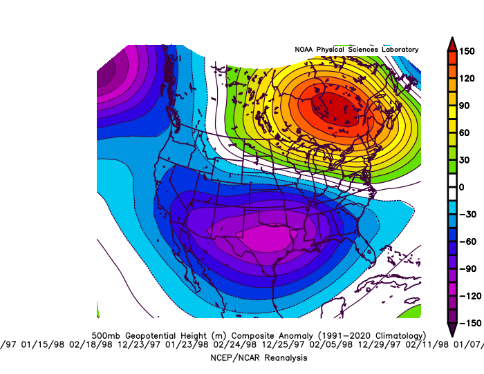
-
What are your thoughts for Union county ?
-
Same amount here, but less than expected. Had to go west to get in on the action.
-
radar looks great for here.. hopefully it doesn't die out by the time it gets here
-
ESOSCALE DISCUSSION 1780 NWS STORM PREDICTION CENTER NORMAN OK 1108 AM CDT TUE JUL 28 2026 AREAS AFFECTED...SOUTHERN PENNSYLVANIA...CENTRAL/SOUTHERN NEW JERSEY...DELAWARE...MARYLAND CONCERNING...SEVERE POTENTIAL...WATCH LIKELY VALID 281608Z - 281815Z PROBABILITY OF WATCH ISSUANCE...80 PERCENT SUMMARY...SEVERE POTENTIAL TO INCREASE THROUGH THE AFTERNOON. DISCUSSION...SHOWER AND THUNDERSTORM ACTIVITY IS ONGOING WITHIN THE WARM AIR ADVECTION ZONE ACROSS PORTIONS OF THE MID-ATLANTIC INTO NEW ENGLAND. MID-LEVEL CLOUD COVER IS IN PLACE ACROSS MUCH OF THE REGION, WHICH IS LIMITING HEATING AND DESTABILIZATION. NONETHELESS, A FEW AREAS OF MORE BROKEN CLOUD COVER HAS ALLOWED FOR FILTERED HEATING , WITH TEMPERATURES IN THE UPPER 70S TO 80S ACROSS PORTIONS OF NEW JERSEY AND DELAWARE. STRENGTHENING MID-LEVEL FLOW IS CONTRIBUTING TO STRONG DEEP LAYER SHEAR AROUND 30-45 KTS ACROSS THE REGION. AS FORCING FOR ASCENT INCREASES AND THE COLD FRONT TO WEST SHIFTS EASTWARD, THUNDERSTORMS ARE EXPECTED TO INCREASE IN COVERAGE AND INTENSITY NEAR AND AHEAD OF THE COLD FRONT. PRIMARY RISKS WILL BE DAMAGING WIND BUT A FEW TRANSIENT SUPERCELLS MAY POSE POTENTIAL FOR A TORNADO. ..THORNTON/HART.. 07/28/2026 ..PLEASE SEE WWW.SPC.NOAA.GOV FOR GRAPHIC PRODUCT ATTN...WFO...PHI...BGM...CTP...LWX...PBZ...
-

Central PA Summer 2026 Discussion/Obs Thread
AccuChris replied to Voyager's topic in Upstate New York/Pennsylvania
Picked up .59” so far for the day. See what the afternoon storms bring . -

2026 Spring/Summer Mountain Thread
franklin NCwx replied to Buckethead's topic in Southeastern States
We have mid 50s showing up in the forecast for a couple days this week! -
 .66 in about a half hour here, and still pouring.
 -
 Looks pretty wet I-84 West
 -
I will take an order of disrupted PV during El Nino and split flow please! LOL. Please hold on the "extended summer."
-

2026 Mid-Atlantic Severe Storm General Discussion
wawarriors4 replied to Kmlwx's topic in Mid Atlantic
Full Sun in Spotsylvania, 86 degrees -
The 90s used to be "not that long ago." And just like that, it is almost 30 years ago. To put that in perspective, the same time span remembrance in 97 would have been like trying to remember 1967! Crap.
-

super el nino banter thread
MJO812 replied to forkyfork's topic in Weather Forecasting and Discussion
Alot of screenshots to bump -
Radar is exploding on the southern edge in PA now. Someone is going to get 6 inches of rain from this.
-
 He also believes gas prices are low and we won the war back in February. No telling what he will believe.
 -
I went to backwater falls last January and it was pretty nice. The “trail” is pretty much a straight walkway down to the falls and there’s some pretty nice photography to be done there. I ditched and just did a long exposure of the water/ice in the snow as the lighting was bad when I went. It’ll probably be crowded, there were several families there even in the dead of winter, so that sorta sucked. Worth a small detour, but I personally loved the red river area far more and plan to go back sometime this or next week (and chimney rocks looks sick, but that’s further from deep creek).
-
 Just drove from Old Saybrook to Deep River/Chester. Nothing doing on the immediate shore but Deep River/Chester had an impressive downpour. Storms moving inland and feeling very juicy out there.