All Activity
- Past hour
-
This
-
Yes sir! Nice steady rains all day and currently.
-
Euro and GFS continue to show this upcoming pattern change.
-
We dodged ducked dipped dove and dodged our way to 0.00” today
-
6-10 day: 8-14 day:
-

Texas 2024 Discussion/Observations
Stx_Thunder replied to Stx_Thunder's topic in Central/Western States
Tons of positive CGs going on: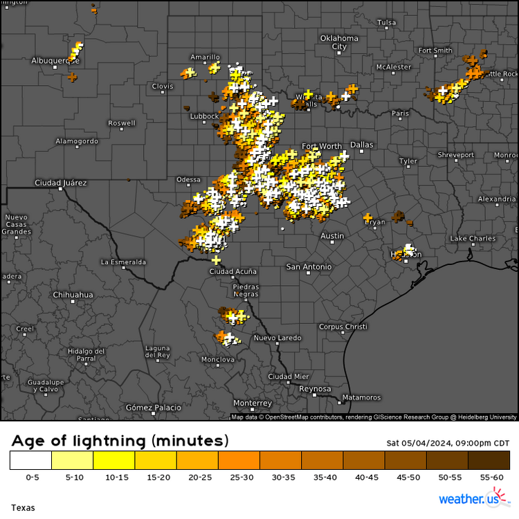
-

May 2024 Discussion - Welcome to Severe Season!!!!
kdxken replied to weatherwiz's topic in New England
You got me. Your guy says everything is looking great for another summer week. Keep those air conditioners locked and loaded.
-
We were pretty much locked in under overcast skies all day with a brisk east wind; 57 was the warmest. Back down to 46 with rain now.
-
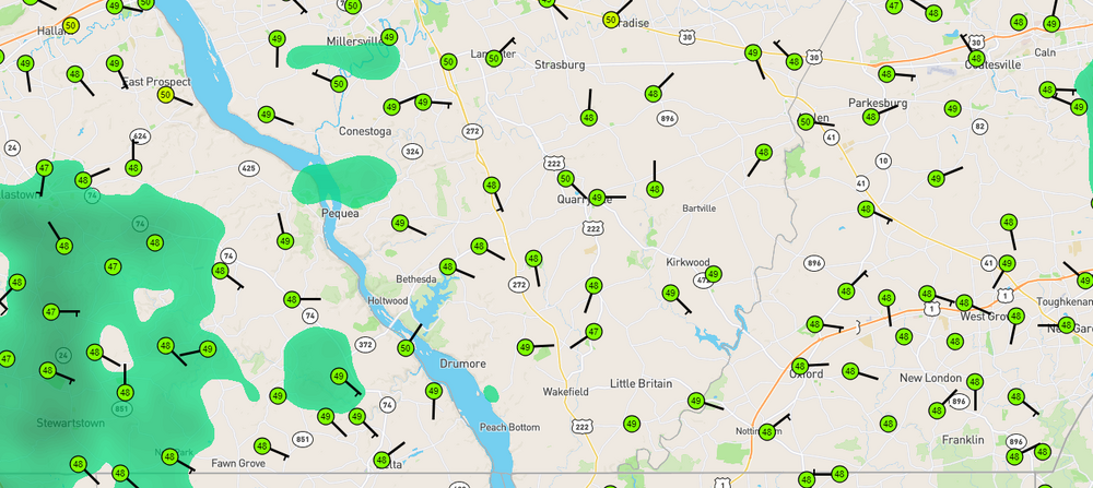
Down to 46 here. Lots of 47-49's in York and Lanco.
-
0.80" for today Temp 52f most of the day. Crummy. Burned 1 batch of mostly oak with a little poplar. Scraping the bottom of the woodpile.
-
Good soaking rain today. 1.35” so far.
- Today
-
May 2024 Discussion - Welcome to Severe Season!!!!
kdxken replied to weatherwiz's topic in New England
46° with an East Wind. Folks loading up with wood today. Brrrr...
-
Today’s Euro weekly is similarly BN for 5/13-20.
-
Severe Weather Statement National Weather Service Midland/Odessa TX 728 PM CDT Sat May 4 2024 TXC443-050100- /O.CON.KMAF.SV.W.0085.000000T0000Z-240505T0100Z/ Terrell TX- 728 PM CDT Sat May 4 2024 ...A SEVERE THUNDERSTORM WARNING REMAINS IN EFFECT UNTIL 800 PM CDT FOR NORTHEASTERN TERRELL COUNTY... At 727 PM CDT, a severe thunderstorm was located 8 miles west of Terrell County Gas Plant, or 22 miles southwest of Sheffield, moving southeast at 20 mph. THIS IS A DESTRUCTIVE STORM FOR CENTRAL TERRELL COUNTY. HAZARD...Softball size hail and 70 mph wind gusts. SOURCE...Radar indicated. IMPACT...People and animals outdoors will be severely injured. Expect shattered windows, extensive damage to roofs, siding, and vehicles. Locations impacted include... Terrell County Gas Plant. PRECAUTIONARY/PREPAREDNESS ACTIONS... A Tornado Watch remains in effect until 1000 PM CDT for southwestern Texas. For your protection move to an interior room on the lowest floor of a building. && LAT...LON 3040 10223 3060 10212 3049 10171 3047 10173 3046 10173 3015 10192 TIME...MOT...LOC 0027Z 299DEG 18KT 3039 10199 THUNDERSTORM DAMAGE THREAT...DESTRUCTIVE HAIL THREAT...RADAR INDICATED MAX HAIL SIZE...4.00 IN WIND THREAT...RADAR INDICATED MAX WIND GUST...70 MPH
-
Early arriving 90F temps locally in a developing La Nina tends to signal a cooler winter in the Southwest. Usually due to one or two severe cold snaps. Currently no support for hitting 90F anytime soon. Year to date, we've yet to hit 85F even actually. I generally look for pre-May 10 as very early - as the average first 90F high here is May 25. The 100-180W subsurface for Feb/Mar/Apr came in at -0.16/-0.54/-0.80. Subsurface El Nino conditions were last March (remember the blizzard warnings in San Diego county?) through January 2024. Here is a similar blend - it's actually a decent match to the May 1 Canadian for DJF 2024-25 SSTs. It's a decent-ish match to what the Canadian shows for US temps in May too. ACE would be around 140 - that's about the lowest realistic number I could see for the Atlantic. I've been expecting 175-225. No method to that. Just my gut. Low ACE La Nina years are also correlated to colder La Ninas in the Southwest with brief periods of severe cold. ---------------------------- 1998: -0.38 / -0.61 / -1.06 2022: 0.12 / -0.47 / -0.34 ----------------------------- Blend: -0.13 / -0.54 / 0.70 2024: -0.16 / -0.54 / -0.80
-

May 2024 Discussion - Welcome to Severe Season!!!!
Sled replied to weatherwiz's topic in New England
Just for the record, it is no longer sunny - Yesterday
-
That they did.
-
Made it to 67 earlier today before thicker clouds arrived. Spotty rain is moving through with barely a trace so far, temp down to 47... house is chilly, debating a fire.
-

Central Pa. Spring 2024
Itstrainingtime replied to mahantango#1's topic in Upstate New York/Pennsylvania
It is a raw evening - 51 here. Rain has stopped. -
You have sprinted past me at ~.25. Down to 47 between 800 and 900 feet elevation. Car Therm said 46 at Pen Mar Park where the elevation is 1400'. This wet "cold" sort of goes through you with any kind of breeze.
-
Central Pa. Spring 2024
Itstrainingtime replied to mahantango#1's topic in Upstate New York/Pennsylvania
Up to .36" of rain at 7pm. -
They both might turn positive for a period later next week, but sustained positive regimes may not occur until later in the month.
- 185 replies
-
- 1
-

-
- spring
- dry weather
- (and 3 more)
-

May 2024 Discussion - Welcome to Severe Season!!!!
DavisStraight replied to weatherwiz's topic in New England
Just had mine done today. First mow. -
I love your enso predictions but can we get a prediction on the AO and NAO,, Don, when do you think it will turn positive?
-
so glad it's not raining here, it was sunny most of the day


