All Activity
- Today
-

Severe Weather 5-6 through 5-8-24
stormdragonwx replied to cheese007's topic in Central/Western States
Fine, I'll be the weather weenie for once and say it goes high risk on Mon morning. lol -

Severe Weather 5-6 through 5-8-24
thunderbird12 replied to cheese007's topic in Central/Western States
The NAM/GFS might be a little too aggressive with moisture return on Monday, with potentially lots of convection and related outflow across Texas the rest of tonight into tomorrow. However, even if the moisture isn't quite as pristine as the NAM/GFS would suggest, Monday still looks like a big severe day. Seems like there has been a trend (especially in the 00Z NAM) for a somewhat stronger secondary shortwave and jet max approaching Oklahoma near and after 00Z Monday evening. That would be an ominous scenario if it verifies. -

Severe Weather 5-6 through 5-8-24
Ed, snow and hurricane fan replied to cheese007's topic in Central/Western States
I hadn't read the ICT discussion but this showed up on X -
Can’t ask for more than an OT game 7. LFG
-
Cool, and damp wx? No debate here...light it up.
-
Way over performed on the rainfall today. Forecast was for 0.5-0.75. Already at 2.25 and coming down hard again. Interesting what the overnight will hold. Supposed to be another 0.5-0.75, but I am guessing it will be more. Lots of heavy rain on the doorstep… .
-
I definitely got ahead of myself. Runs today have significantly downtrended the northern end of the threat.
-
don't get ahead of yourself...
-

Central Pa. Spring 2024
Itstrainingtime replied to mahantango#1's topic in Upstate New York/Pennsylvania
Puking snow in Mammoth Lakes. Coming up on one year since I was there. -

May 2024 Discussion - Welcome to Severe Season!!!!
Torch Tiger replied to weatherwiz's topic in New England
Looks seasonably mild/cool through the next 10 -
May 2024 Discussion - Welcome to Severe Season!!!!
Torch Tiger replied to weatherwiz's topic in New England
It was in the 60's here today. Are they a day drinker? -
This
-
Yes sir! Nice steady rains all day and currently.
-
Euro and GFS continue to show this upcoming pattern change.
-
We dodged ducked dipped dove and dodged our way to 0.00” today
-
6-10 day: 8-14 day:
-

Texas 2024 Discussion/Observations
Stx_Thunder replied to Stx_Thunder's topic in Central/Western States
Tons of positive CGs going on: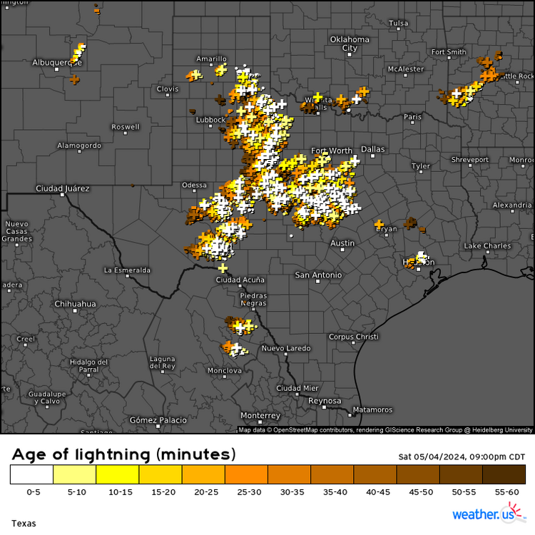
-

May 2024 Discussion - Welcome to Severe Season!!!!
kdxken replied to weatherwiz's topic in New England
You got me. Your guy says everything is looking great for another summer week. Keep those air conditioners locked and loaded.
-
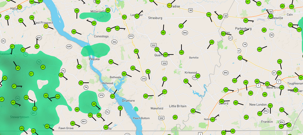
We were pretty much locked in under overcast skies all day with a brisk east wind; 57 was the warmest. Back down to 46 with rain now.
-
Down to 46 here. Lots of 47-49's in York and Lanco.
-
0.80" for today Temp 52f most of the day. Crummy. Burned 1 batch of mostly oak with a little poplar. Scraping the bottom of the woodpile.
-
Good soaking rain today. 1.35” so far.
-
May 2024 Discussion - Welcome to Severe Season!!!!
kdxken replied to weatherwiz's topic in New England
46° with an East Wind. Folks loading up with wood today. Brrrr...
-
Today’s Euro weekly is similarly BN for 5/13-20.
-
Severe Weather Statement National Weather Service Midland/Odessa TX 728 PM CDT Sat May 4 2024 TXC443-050100- /O.CON.KMAF.SV.W.0085.000000T0000Z-240505T0100Z/ Terrell TX- 728 PM CDT Sat May 4 2024 ...A SEVERE THUNDERSTORM WARNING REMAINS IN EFFECT UNTIL 800 PM CDT FOR NORTHEASTERN TERRELL COUNTY... At 727 PM CDT, a severe thunderstorm was located 8 miles west of Terrell County Gas Plant, or 22 miles southwest of Sheffield, moving southeast at 20 mph. THIS IS A DESTRUCTIVE STORM FOR CENTRAL TERRELL COUNTY. HAZARD...Softball size hail and 70 mph wind gusts. SOURCE...Radar indicated. IMPACT...People and animals outdoors will be severely injured. Expect shattered windows, extensive damage to roofs, siding, and vehicles. Locations impacted include... Terrell County Gas Plant. PRECAUTIONARY/PREPAREDNESS ACTIONS... A Tornado Watch remains in effect until 1000 PM CDT for southwestern Texas. For your protection move to an interior room on the lowest floor of a building. && LAT...LON 3040 10223 3060 10212 3049 10171 3047 10173 3046 10173 3015 10192 TIME...MOT...LOC 0027Z 299DEG 18KT 3039 10199 THUNDERSTORM DAMAGE THREAT...DESTRUCTIVE HAIL THREAT...RADAR INDICATED MAX HAIL SIZE...4.00 IN WIND THREAT...RADAR INDICATED MAX WIND GUST...70 MPH


