All Activity
- Past hour
-

E PA/NJ/DE Winter 2025-26 Obs/Discussion
Mikeymac5306 replied to LVblizzard's topic in Philadelphia Region
I think I have about 15-20 flakes that landed on my patio table this morning. I am not buying the GFS either considering it's track record this year. Doesn't look like the local mets are buying it as well. Still banking on the storms next week to hamper my travel plans. Fantasy land has March coming in like a lion. -
The trend for over a year now since the drought pattern started has been for the models to show a lot of QPF at range only to drop it significantly as we get closer in time. The overall dryness since September, 2024 has been staggering, we’ve left the 2001-02 drought in the dust, it’s not even close
-
As we get into next week, if things keep trending colder, maybe "Hub" will do another thread, he is on a roll lately! 26F/light clouds
-

E PA/NJ/DE Winter 2025-26 Obs/Discussion
Duca892 replied to LVblizzard's topic in Philadelphia Region
Why is there that amount of disparity amongst models in the year 2026 lol -
Comedian - where can we catch your act ?
-
Moon angle. The moon reflects the sun's light.
-

January 25-26 Winter Storm Potential
Physicsteve replied to Ralph Wiggum's topic in Philadelphia Region
I still had snow otg from the 6” I got the weekend before, 1/17-18, so getting close to a full month here. It’s been a very picturesque wintery month. eta dogs and small children are still able to walk on top of the snow without falling in as well for the most part. -
It happens at night lol
-
Ensembles show us getting a lot more active but until it happens the dryness will continue. I don't even care if it snows again, we just need precip asap.
-
 Baum changed their profile photo
 -
Mount Snow was excellent yesterday! It looked and felt busy but most lifts were ski on. They got about 8” of new snow the previous couple days and it really helped conditions. Natural snow trails and woods skied very well. I managed a nice loop around the hill hitting both on map and off spots from all lifts until I had to jet to go get my youngest at school. Great day overall! I’ve been so busy lately I haven’t really been able to go anywhere else besides what I can access around here but I will say it’s been excellent. Hope we can get another storm or two in February and avoid any big warmups and or rain. .
-
Swwwwww lovely hiking weather. I'd love to be up there Tahoe for this entire week. Those accumulation look nice and slow. On the Tug they'd get all that snow in about 5 hours and then the sun would be out. Next day.. it's does it again lol.
-

2025-2026 Fall/Winter Mountain Thread
ncjoaquin replied to Buckethead's topic in Southeastern States
Surprisingly made it down to 21.0. Just like every rainfall for the last 6 months, the expected amount has trended down all week. Hopefully, I can pull out a half inch of rain. We need it! -
A similar experience for me as we must be around the same age, I was in 5th grade. We lived in Fishkill at the time and I wasn't sure it was ever going to reach up there, it finally did in the evening. Woke up to around 18" the next morning and thought it was the greatest thing ever. And I vividly remember getting the combo sun/wind burn while playing outside in the following days. I also remember getting a headache because it was so bright outside.
-

E PA/NJ/DE Winter 2025-26 Obs/Discussion
Ralph Wiggum replied to LVblizzard's topic in Philadelphia Region
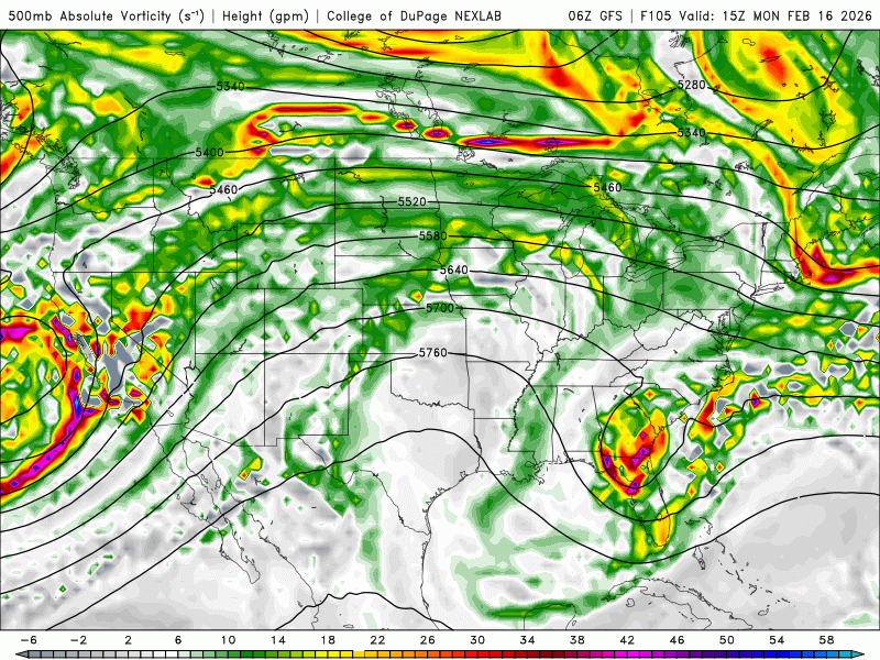
Outside of the 12k nam the mesos have zero interest in this event. Thats a red flag that leans against a snow event imho. Not sure i trust the globals at this range. -
Doesn't look great rest-of-the-month. Hopefully, we can have one more forum-wide storm to track before spring. I'm enjoying the winter break for sure, but not ready to say goodbye entirely.
-
Because I’m not a vampire
-
Imagine being in a nice cabin in Tahoe this week. Dailylurker would hike in this Washington's Birthday Snow. High near 33. Calm wind becoming south around 5 mph in the afternoon. Chance of precipitation is 100%. New snow accumulation of 3 to 7 inches possible. Monday Night Snow. The snow could be heavy at times. Low around 16. Southwest wind around 10 mph, with gusts as high as 35 mph. Chance of precipitation is 100%. New snow accumulation of 5 to 9 inches possible. Tuesday Snow. The snow could be heavy at times. High near 26. Chance of precipitation is 100%. New snow accumulation of 9 to 13 inches possible. Tuesday Night Snow. The snow could be heavy at times. Cloudy, with a low around 12. Wednesday Snow. The snow could be heavy at times. Mostly cloudy, with a high near 26.
-
Why?
-
Winter 2025-26 Medium/Long Range Discussion
Baum replied to michsnowfreak's topic in Lakes/Ohio Valley
The northeast and mid Atlantic are nearing some of the lengthiest snow packs in decades with near records in some cases. And most of it stemmed from an event 2-3 weeks ago. Was not aware climatologicaly how much easier it is for our area to retain snow cover versus them. Here, a 2-3 week cover from a 10” event in mid winter is standard. Heck, this pack were melting off is basically from a duster train and lake effect event. I figured it’d go poof. Not so. But another day of 50’s will end it. Bring on a salt washer. Of course we’ll probably follow that with an 8” tree snapper. -
Definitely a trend to speed up that southern stream though allowing that northern stream to dig and partially phase.
-
The storm that will devastate the Sierra with high winds and brobdingnagian amounts of snow Sunday night thru Thursday next week, ORIGINATES FROM ALASKA. It will be a frigid storm laden to the gills with enormous amounts of Pacific moisture. It will smash into all the California mountains and be forced violently upward condensing into ridiculous quantities of torrential snow that will simply pile up, feet and feet maybe meters. High winds will pile up drifts and cornices at ridges that will result in severe avalanche dangers. In short, this is not the weekend to go skiing along the Sierras. Travel will be impossible. This storm is so cold that it will snow on the valley floors. Every mountain in California including the coastal ranges will be utterly demolished with snow. New records will be set. Models are depicting up to 7 inches of pure water. Snow to water ratios will increase to 14 to 1. This is going to be BAD. THIS STORM WILL TAKE NO PRISONERS. This storm is only the first in a classic Pacific Set.
-
E PA/NJ/DE Winter 2025-26 Obs/Discussion
Duca892 replied to LVblizzard's topic in Philadelphia Region
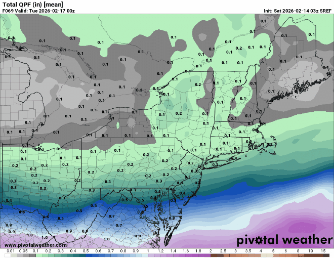
Looks pretty ok for a light 1-3in snowfall for the Lehigh Valley with 2-4in around Bucks/Phillg areas -
-
Not gonna be happy if I end up with clouds out of this Monday
-

Is we back? February discussion thread
Damage In Tolland replied to mahk_webstah's topic in New England
Seemed like one bad run at 00z . With that cold high up there and - NAO. Cold should be the thinking


