All Activity
- Past hour
-
The EPO ridge and improving pacific makes January interesting. Best pattern we have seen in years coming imo
-
Same in ASH.....
-
In February 1983, we still had a few inches of icy snow left from a moderate snowfall the week before the blizzard. Of course the melt out following the blizzard was epic. Excellent lasting snowpack in both 2014 and 2015. Even 2001 was decent.
-

Wounded Duck Strikes Back: Dec 26 & 27th Winter Storm Obs
tamarack replied to WxWatcher007's topic in New England
Decent, though no blockbusters. Same here, proportionally to climo snow - now 20.3" for the month (no flakes from yesterday, as forecast). Tomorrow night/Monday looks to be mostly IP/ZR here. -

December 2025 regional war/obs/disco thread
VivaManchVegas replied to Torch Tiger's topic in New England
13 here. About 4 degrees lower than expected based on GYX forecast. -
I would think water content would be more meaningful than depth. Not that measuring air has no value.
-
We don't even need to go back that far to get a mean monthly temp of 25. That happened in February 2015, part of a 3-month period (January-March 2015) that was the coldest post-1980.
-

December 2025 regional war/obs/disco thread
AstronomyEnjoyer replied to Torch Tiger's topic in New England
Not sure. Looks like she hasn't been active since earlier this month. Hope she's doing well though. -
Lamar G III out again?
-
Every 6 hours was silly. The actual snowfall is what is on the ground (or measuring surface), rather than a theoretical depth not accounting for gravity or other physical properties. And I believe there is an average based on a differernt number of spots, so as to account for variations due to drifting, or is this just for larger snow falls?
-
yes but earlier on the 1st - will be interesting to see how this evolves and if the developing LP taps additional moisture from the ocean
-
Pretty chilly so far tonight, temp down to 12F already; how low are we going?
-
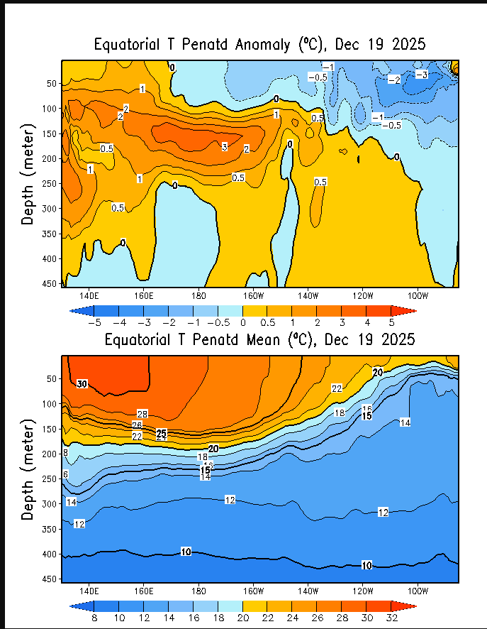
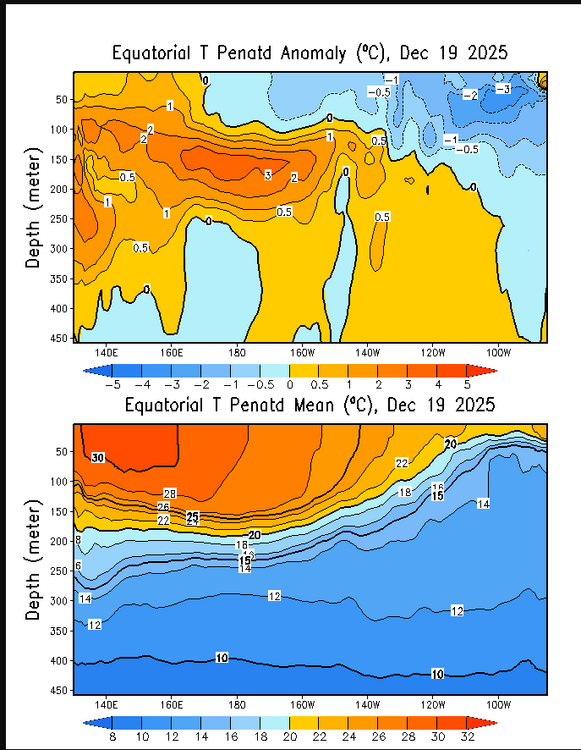
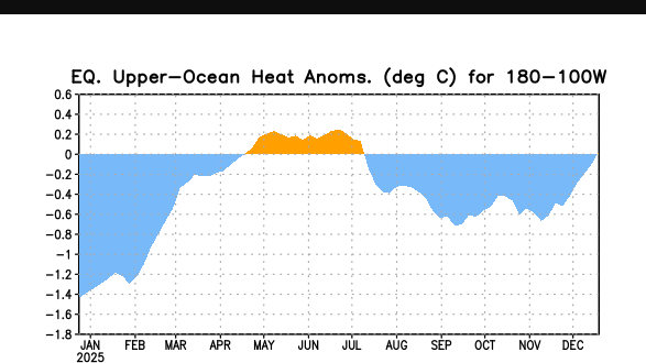
Has NINA actually not peaked,i mean the East is warning and the west gets cooler each day
-
Yeah, I tried about 30 seconds of getting that bottom layer of frozen cement up and promptly decided to just shovel off all the loose snow/sleet and then I spent 5 minutes putting salt down, went and did a bunch of errands, and when I came back the cement was melted in spots making removal easy.
-

Wounded Duck Strikes Back: Dec 26 & 27th Winter Storm Obs
George001 replied to WxWatcher007's topic in New England
Yeah this month underperformed. The late north trends for this past storm were nice, but I only got 3 or so inches and it’s probably going to be gone unless Monday trends a lot colder. Oh well, the January pattern looks promising for a minor threat (4-8 ish if everything breaks right) around new years and a bigger storm on the 6th. -
They've issues some WSW that other offices would call blizzard warnings. Just like GRR with their advisory for a lake squall or 4-7" synoptic snow. I put little faith in the nws offices decision on what to issue
-

Wounded Duck Strikes Back: Dec 26 & 27th Winter Storm Obs
CoastalWx replied to WxWatcher007's topic in New England
6” for the month. Meh. Especially with this cold. -

Winter 2025-2026 Offers Return to Normalcy
SJonesWX replied to 40/70 Benchmark's topic in New England
B-? I respect your forecasts and you putting yourself out there, I really do. Had you not put in the 6-10” area you would have had an A for sure. But you owned up to that mistake which is admirable. I guess I’m not sure that I agree with your grading, but as I type this I’m not sure you were that far off with your grade. C+ maybe? -
Man, the Chargers got screwed on that contact call.
-
18z euro also shows this
-
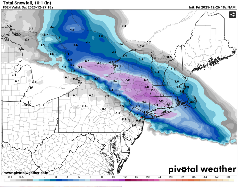
The numbers from the 18z 12/26 NAM run on Pivotal (which doesn't add anything to the totals for sleet) were: Bridgeport: 5.8 Islip Airport: 5.0 Central Park: 2.8 Newark Airport: 0.8 However, the annotated totals shown for NWS reporting stations don't match the colored boundaries drawn on the map. I've marked Newark Airport and MacArthur Airport with red dots as an example. Based on the graphical boundaries and the legend, the estimated NAM totals are: Bridgeport: 5.5 Islip Airport: 5.5 Central Park: 2.8 Newark Airport: 1.8 So now I'm wondering how the values shown on Pivotal get populated. Is the data drawn from the exact lat lon of the reporting station cross referenced to the raw NAM data, or is there some kind of apprimation going on...?
-
Thanks, it’s other drivers who always worry me. MNDOT and the local agencies will do a fine job as always.
-

December 2025 regional war/obs/disco thread
Sey-Mour Snow replied to Torch Tiger's topic in New England
Where is your sidekick poster from last year?? -
December 2025 regional war/obs/disco thread
Sey-Mour Snow replied to Torch Tiger's topic in New England
What’s up with the influx of users I’ve never heard of ? -
Need better then