All Activity
- Past hour
-
81/48 Gah it’s so nice outside.
-
Got this from Google A.I. when asked about this. Take it for what it's worth: Yes, a pro-Iranian hacker group called the "Islamic Cyber Resistance in Iraq – 313 Team" claimed responsibility for a sophisticated cyberattack that caused intermittent outages and slowed down the National Weather Service. The disruption began around 8:45 a.m. EDT over the weekend and primarily impacted weather.gov and local NWS forecast pages. The hacktivist group specifically targeted the agency just as a dangerous, record-breaking heat wave began sweeping across the United States. While the NWS acknowledged the stability issues and database errors, they stated that their local offices continued to issue official watches, warnings, and forecasts
-
i was being facetious lol. I do remember somewhat frequent brownouts due to heat in the mid-late 1990s.
-
My west facing analog therm has hit 100+ several times already this year :-)
-
I'm going by the Staunton official records. A thermometer exposed to the rays of the sun or other artificial heating can register significantly higher than actual air temperature. Even reflective heat can artificially inflate the temperature.
-
Fireworks Heat Contest W 7/1 - S 7/4 for Five MA Airports
Roger Ramjet replied to nw baltimore wx's topic in Mid Atlantic
DCA: 96, 101, 102, 100 BWI: 97, 102, 101, 99 IAD: 96, 102, 101, 100 SBY: 95, 100, 100, 99 RIC: 98, 103, 102, 101 Total Rain: 0.00 -
Damn! If that’s true, that’s kinda bananas. Was going to Gilgo and wanted to see about any possible rip currents during the morning and the site was down. And then when I saw the heat models being posted in this thread for this week, when we got back, went to NWS and saw it was still down.
-
Models are always bad in mesoscale season, as you know. At least this website is back to normal speed. Saturday had Crossville special written all over it. I gave up mid-afternoon after cells near Pikeville looked like crap. Then at sunset while I'm back home enjoying the World Cup, tornado warning Cumberland Co. What a hobby!
-
no shortage of warm air and 70+ dps on the gfs, even selling some widespread 80+ dps into fantasy range
-
For tomorrow URGENT - WEATHER MESSAGE National Weather Service Baltimore MD/Washington DC 1243 PM EDT Mon Jun 29 2026 MDZ502-WVZ050-055-502-504-506-300100- /O.NEW.KLWX.HT.Y.0003.260630T1500Z-260701T0000Z/ Central and Eastern Allegany-Hampshire-Hardy-Eastern Grant- Eastern Mineral-Eastern Pendleton- 1243 PM EDT Mon Jun 29 2026 ...HEAT ADVISORY IN EFFECT FROM 11 AM TO 8 PM EDT TUESDAY... * WHAT...Heat index values up to 102 expected. * WHERE...In Maryland, Central and Eastern Allegany County. In West Virginia, Eastern Grant, Eastern Mineral, Eastern Pendleton, Hampshire, and Hardy Counties. * WHEN...From 11 AM to 8 PM EDT Tuesday. * IMPACTS...Hot temperatures and high humidity may cause heat illnesses. PRECAUTIONARY/PREPAREDNESS ACTIONS... Drink plenty of fluids, stay in an air-conditioned room, stay out of the sun, and check up on relatives and neighbors. Take extra precautions when outside. Wear lightweight and loose fitting clothing. Try to limit strenuous activities to early morning or evening. Take action when you see symptoms of heat exhaustion and heat stroke. To reduce risk during outdoor work, the Occupational Safety and Health Administration recommends scheduling frequent rest breaks in shaded or air conditioned environments. Anyone overcome by heat should be moved to a cool and shaded location. Heat stroke is an emergency! In cases of heat stroke, call 9 1 1.
-
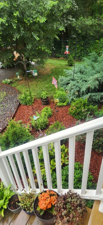
Off and on showers - little bit of additional accumulation... Everything just feels and looks a bit better after last evenings rainfall... Fresh mulch with some rain on it has a nice smell at least to me...
-
Just an insane presentation still. Even looks like there may be a rain wrapped tornado
-
Got this message from work. NYC Emergency Management has implemented their flash flood emergency plan due to thunderstorms. I don't see any thunderstorms in the forecast for NYC today or tomorrow and a 20% chance on Wednesday.
-
This thing is still chugging along through the forests of Minnesota. HRRR says Canada denies it entry, but would be cool to see this thing survive and arrive tomorrow morning.
-

2026-2027 Super El Nino
40/70 Benchmark replied to Stormchaserchuck1's topic in Weather Forecasting and Discussion
Agree...it will also be well above in the mean because were aren't getting cold of that magnitude, nor as protracted later in the season. I am NOT trying to imply that this year will be like the colder basin-wide seasons like 2002 when I call it basin-wide. -

Fireworks Heat Contest W 7/1 - S 7/4 for Five MA Airports
MN Transplant replied to nw baltimore wx's topic in Mid Atlantic
DCA: 95, 100, 101, 97 BWI: 95, 100, 101, 97 IAD: 95, 100, 101, 97 SBY: 91, 98, 98, 98 RIC: 95, 98, 99, 99 Total Rain: 1.34" -
*forgets sunburn won't be a thing*
-
My front lawn is on a small hill facing north under a tree. Trees line the curb on the other side of the sidewalk. I would love turf to keep the leaves from settling in between blades and creating bare spots. In addition to the moss that takes over because of the north facing lawn with low sunlight. I thought about putting fake grass down. lol
-
I dunno man, the thermometer at Westside pool in Staunton's west end had frequent 100+ readings back in the 1990s!
-
12z GFS not backing off the heat for Thursday and Friday. 104 in Central Park for Thursday, with some 106 readings near Newark, and 105 in Central Park on Friday, with some 106 readings in northern Manhattan/Hudson County. At least humidity will be minimal.
-
(002).thumb.png.6e3d9d46bca5fe41aab7a74871dd8af8.png)
Central PA Summer 2026 Discussion/Obs Thread
ChescoWx replied to Voyager's topic in Upstate New York/Pennsylvania
With a chance that some locations could see a 100-degree day later this week I went back and analyzed 30 temperature stations across the area to see just how rare such a day has become. A 100-degree day is a rare occurrence across most spots across the County. With the potential being even more rare across the relatively higher ridge stations above 595 ft. In fact the last time any ridge location station saw a 100-degree reading was 15 years ago back on July 22, 2011. Of the 18 current stations across the area that report temperatures 9 of these have never recorded such a day. Our lowest elevation stations at Phoenixville and nearby Spring City both recorded a 100+ day last June. To illustrate how different the temperature elevation impact can be on June 26, 2025 while Spring City (256 ft ASL) was hitting the century mark....not too far away at Glenmoore DEOS (620 FT ASL) but 400 feet higher the high was 10 degrees cooler at "only" 90.6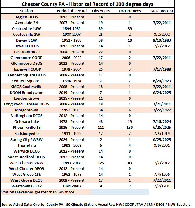
-
E PA/NJ/DE Summer 2026 Obs/Discussion
ChescoWx replied to PhiEaglesfan712's topic in Philadelphia Region
With a chance that some locations could see a 100-degree day later this week I went back and analyzed 30 temperature stations across the area to see just how rare such a day has become. A 100-degree day is a rare occurrence across most spots across the County. With the potential being even more rare across the relatively higher ridge stations above 595 ft. In fact the last time any ridge location station saw a 100-degree reading was 15 years ago back on July 22, 2011. Of the 18 current stations across the area that report temperatures 9 of these have never recorded such a day. Our lowest elevation stations at Phoenixville and nearby Spring City both recorded a 100+ day last June. To illustrate how different the temperature elevation impact can be on June 26, 2025 while Spring City (256 ft ASL) was hitting the century mark....not too far away at Glenmoore DEOS (620 FT ASL) but 400 feet higher the high was 10 degrees cooler at "only" 90.6
-
he said noisy, not nosey
-
ridge roller season getting into full swing this week, looking forward to the axis sinking south as we head into july latest euro selling a classic look
-
Up to 87 quickly today