All Activity
- Past hour
-
Showers in OC.
-
Seriously. I had the same thought. Feels like I’m wearing the air. Pretty dense fog here next to the lake too
-
0.3" last night, a lot of thunder and lightning
-
82/81 at MSP this morning. Here’s a tidbit from KMPX At 2 AM, the dew point at MSP climbed to 81. This has only happened on a few days in recorded history. Per the Minnesota State Climatology Office, an 81 degree dew point was measured on July 17, 2011; July 18, 2011; July 19, 2011; and July 30, 1999. The all-time record is 82 set back on July 19, 2011.
-
Idk about storms but not sure ive ever experienced this kind of early am heat and humidity, feels like a sauna
-
 down in the 50s again, what a run heading to the river to enjoy some morning coffee
 -
NYC can have a similar temperature as Newark on days with S to NE cooler onshore flow. Newark gets a cooling breeze off the bay and Central Park doesn’t since it’s not right on the water like the airport at Newark is. A few days ago with more offshore flow Newark was warmer again since they didn’t have a cooling breeze. The days when the trees have a more significant cooling influence relative to the airports are more offshore flow days with SW to NW flow at Newark. Also cloudy days since this removes the cooling influence of the trees when it’s not sunny. Onshore flow similar temperatures CLIMATE REPORT NATIONAL WEATHER SERVICE NEW YORK, NY 234 AM EDT MON JUL 27 2026 ................................... ...THE NEWARK NJ CLIMATE SUMMARY FOR JULY 26 2026... CLIMATE NORMAL PERIOD 1991 TO 2020 CLIMATE RECORD PERIOD 1931 TO 2026 WEATHER ITEM OBSERVED TIME RECORD YEAR NORMAL DEPARTURE LAST VALUE (LST) VALUE VALUE FROM YEAR NORMAL ................................................................... TEMPERATURE (F) YESTERDAY MAXIMUM 85 310 PM 99 1940 87 -2 85 1989 2005 MINIMUM 65 526 AM 57 1953 70 -5 76 AVERAGE 75 78 -3 81 PRECIPITATION (IN) YESTERDAY 0.00 2.72 1985 0.15 -0.15 0.00 MONTH TO DATE 4.31 3.84 0.47 3.21 SINCE JUN 1 6.83 8.18 -1.35 5.50 SINCE JAN 1 20.65 26.55 -5.90 20.56 SNOWFALL (IN) YESTERDAY 0.0 T 2009 0.0 0.0 0.0 MONTH TO DATE 0.0 0.0 0.0 0.0 SINCE JUN 1 0.0 0.0 0.0 0.0 SINCE JUL 1 0.0 0.0 0.0 0.0 SNOW DEPTH 0 DEGREE DAYS HEATING YESTERDAY 0 0 0 0 MONTH TO DATE 0 0 0 0 SINCE JUN 1 0 14 -14 10 SINCE JUL 1 0 0 0 0 COOLING YESTERDAY 10 13 -3 16 MONTH TO DATE 359 343 16 437 SINCE JUN 1 674 588 86 767 SINCE JAN 1 829 672 157 849 ................................................................... WIND (MPH) HIGHEST WIND SPEED 10 HIGHEST WIND DIRECTION S (190) HIGHEST GUST SPEED 15 HIGHEST GUST DIRECTION SE (150) AVERAGE WIND SPEED 4.5 822 CDUS41 KOKX 270634 CLINYC CLIMATE REPORT NATIONAL WEATHER SERVICE NEW YORK, NY 234 AM EDT MON JUL 27 2026 ................................... ...THE CENTRAL PARK NY CLIMATE SUMMARY FOR JULY 26 2026... CLIMATE NORMAL PERIOD 1991 TO 2020 CLIMATE RECORD PERIOD 1869 TO 2026 WEATHER ITEM OBSERVED TIME RECORD YEAR NORMAL DEPARTURE LAST VALUE (LST) VALUE VALUE FROM YEAR NORMAL ................................................................... TEMPERATURE (F) YESTERDAY MAXIMUM 85 211 PM 98 1940 85 0 85 MINIMUM 64 536 AM 55 1920 70 -6 74 AVERAGE 75 78 -3 80 PRECIPITATION (IN) YESTERDAY 0.00 3.24 2000 0.15 -0.15 0.00 MONTH TO DATE 3.69 3.78 -0.09 3.43 SINCE JUN 1 7.08 8.32 -1.24 5.89 SINCE JAN 1 21.51 27.49 -5.98 24.45 SNOWFALL (IN) YESTERDAY 0.0 0.0 2001 0.0 0.0 0.0 2002 MONTH TO DATE 0.0 0.0 0.0 0.0 SINCE JUN 1 0.0 0.0 0.0 0.0 SINCE JUL 1 0.0 0.0 0.0 0.0 SNOW DEPTH 0 DEGREE DAYS HEATING YESTERDAY 0 0 0 0 MONTH TO DATE 0 0 0 0 SINCE JUN 1 4 15 -11 16 SINCE JUL 1 0 0 0 0 COOLING YESTERDAY 10 13 -3 15 MONTH TO DATE 314 327 -13 368 SINCE JUN 1 576 553 23 640 SINCE JAN 1 714 634 80 697 ................................................................... WIND (MPH) HIGHEST WIND SPEED 9 HIGHEST WIND DIRECTION NE (40) HIGHEST GUST SPEED 16 HIGHEST GUST DIRECTION NE (50) AVERAGE WIND SPEED 1.6 Offshore flow Newark 5 degrees warmer with no cooling seabreeze CLIMATE REPORT NATIONAL WEATHER SERVICE NEW YORK, NY 219 AM EDT THU JUL 23 2026 ................................... ...THE NEWARK NJ CLIMATE SUMMARY FOR JULY 22 2026... CLIMATE NORMAL PERIOD 1991 TO 2020 CLIMATE RECORD PERIOD 1931 TO 2026 WEATHER ITEM OBSERVED TIME RECORD YEAR NORMAL DEPARTURE LAST VALUE (LST) VALUE VALUE FROM YEAR NORMAL ................................................................... TEMPERATURE (F) YESTERDAY MAXIMUM 90 348 PM 108 2011 87 3 80 MINIMUM 72 1159 PM 56 1944 70 2 67 AVERAGE 81 78 3 74 PRECIPITATION (IN) YESTERDAY 0.00 1.78 2019 0.16 -0.16 0.00 MONTH TO DATE 4.31 3.21 1.10 2.70 SINCE JUN 1 6.83 7.55 -0.72 4.99 SINCE JAN 1 20.65 25.92 -5.27 20.05 SNOWFALL (IN) YESTERDAY 0.0 0.0 2001 0.0 0.0 0.0 2002 MONTH TO DATE 0.0 0.0 0.0 0.0 SINCE JUN 1 0.0 0.0 0.0 0.0 SINCE JUL 1 0.0 0.0 0.0 0.0 SNOW DEPTH 0 DEGREE DAYS HEATING YESTERDAY 0 0 0 0 MONTH TO DATE 0 0 0 0 SINCE JUN 1 0 14 -14 10 SINCE JUL 1 0 0 0 0 COOLING YESTERDAY 16 14 2 9 MONTH TO DATE 326 291 35 372 SINCE JUN 1 641 536 105 702 SINCE JAN 1 796 620 176 784 ................................................................... WIND (MPH) HIGHEST WIND SPEED 22 HIGHEST WIND DIRECTION N (350) HIGHEST GUST SPEED 32 HIGHEST GUST DIRECTION W (270) AVERAGE WIND SPEED 14.2 CLIMATE REPORT NATIONAL WEATHER SERVICE NEW YORK, NY 432 PM EDT WED JUL 22 2026 ................................... ...THE CENTRAL PARK NY CLIMATE SUMMARY FOR JULY 22 2026... VALID TODAY AS OF 0400 PM LOCAL TIME. CLIMATE NORMAL PERIOD 1991 TO 2020 CLIMATE RECORD PERIOD 1869 TO 2026 WEATHER ITEM OBSERVED TIME RECORD YEAR NORMAL DEPARTURE LAST VALUE (LST) VALUE VALUE FROM YEAR NORMAL ................................................................... TEMPERATURE (F) TODAY MAXIMUM 85 249 PM 104 2011 85 0 81 MINIMUM 72 1202 AM 58 1871 71 1 67 1890 AVERAGE 79 78 1 74 PRECIPITATION (IN) TODAY 0.00 1.86 1880 0.15 -0.15 0.00 MONTH TO DATE 3.69 3.17 0.52 3.42 SINCE JUN 1 7.08 7.71 -0.63 5.88 SINCE JAN 1 21.51 26.88 -5.37 24.44 SNOWFALL (IN) TODAY 0.0 0.0 2001 0.0 0.0 0.0 2002 MONTH TO DATE 0.0 0.0 0.0 0.0 SINCE JUN 1 0.0 0.0 0.0 0.0 SINCE JUL 1 0.0 0.0 0.0 0.0 SNOW DEPTH 0 DEGREE DAYS HEATING TODAY 0 0 0 0 MONTH TO DATE 0 0 0 0 SINCE JUN 1 4 15 -11 16 SINCE JUL 1 0 0 0 0 COOLING TODAY 14 13 1 9 MONTH TO DATE 281 275 6 308 SINCE JUN 1 543 501 42 580 SINCE JAN 1 681 582 99 637 ................................................................... WIND (MPH) HIGHEST WIND SPEED 14 HIGHEST WIND DIRECTION W (270) HIGHEST GUST SPEED 24 HIGHEST GUST DIRECTION W (260) AVERAGE WIND SPEED 7.2
-
There were quite a lot of hail cores and "large hail" last night... I saw numerous statements and warnings for ping pong to baseball sized hail
-
no need
-

Central PA Summer 2026 Discussion/Obs Thread
mahantango#1 replied to Voyager's topic in Upstate New York/Pennsylvania
US National Weather Service State College PA Monday - July 27, 2026 @6 AM EDT: Several rounds of showers and thunderstorms will be moving southeast across PA this afternoon through Tuesday, and lingering into the midweek period over Eastern PA. This will bring the threat of localized severe weather in the form of some instances of strong/damaging wind gusts. Then, the focus will shift to areas of potentially excessive rainfall for Tuesday and Wednesday. Here is a loop of forecast model radar reflectivity - every 2 hours from 10 AM today to 2 pm Tuesday, followed by storm total rainfall from 2 pm this afternoon trough 8 pm Wednesday -
 51° here for the third day in a row. Never made the 40s.
 -

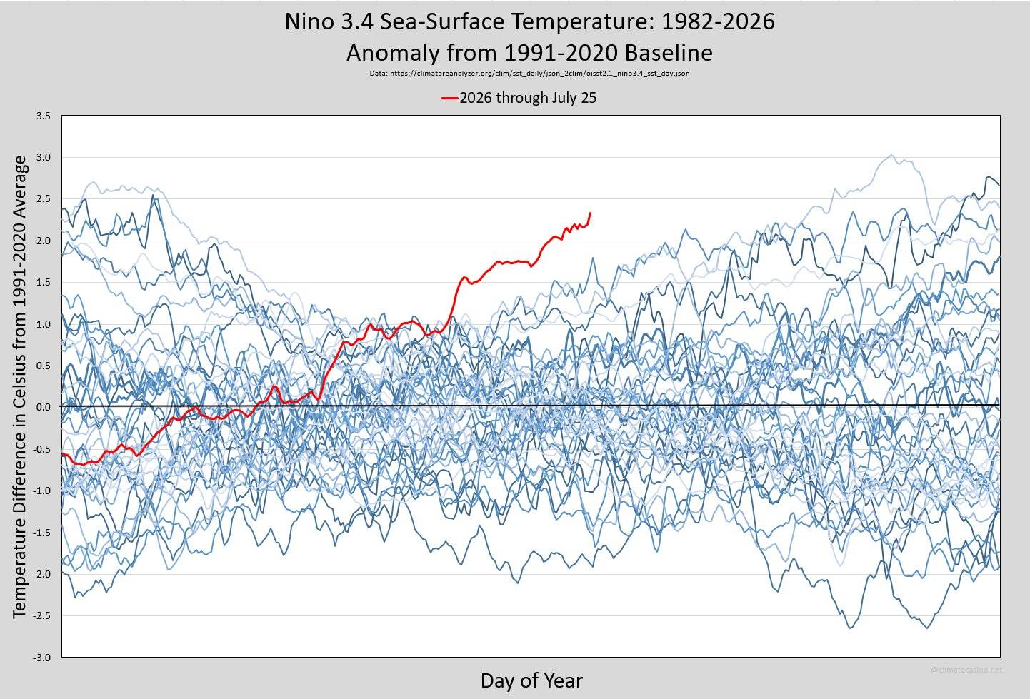
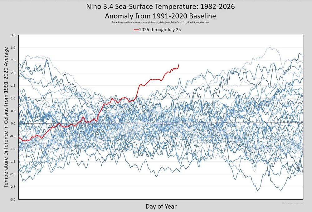
2026-2027 Super El Nino
bluewave replied to Stormchaserchuck1's topic in Weather Forecasting and Discussion
The current -PNA is mostly a reflection of how strong the ridge is north of Hawaii. That’s the really strong 500 mb -PDO we are getting in July. The SSTs are mostly a lagging indicator since the 500mb drove the PDO decline since June. But there is probably a background feedback between the SST and atmosphere which has kept the -PDO so negative during the 2020s. This summer PDO drop has been a common theme during the 2020s with a gradual rise to less negative by the winter. So our new 2020s seasonal cycle. We can’t really predict the PNA beyond the short term so too early to put out a precise winter PNA forecast. But just to say that the 2023-2024 super El Niño with a -PDO had a less positive winter PNA than 2015-2016 with a strong +PDO DJF 2023-2024…….PNA…..+0.58…..PDO…..-1.34 DJF 2015-2016……..PNA……+1.42…..PDO…..+1.07 -
Central PA Summer 2026 Discussion/Obs Thread
mahantango#1 replied to Voyager's topic in Upstate New York/Pennsylvania
Hazardous Weather Outlook National Weather Service State College PA 330 AM EDT Mon Jul 27 2026 PAZ017>019-024>028-033>036-045-046-049>053-056>059-063>066-280730- Clearfield-Northern Centre-Southern Centre-Cambria-Blair-Huntingdon- Mifflin-Juniata-Somerset-Bedford-Fulton-Franklin-Southern Clinton- Southern Lycoming-Union-Snyder-Montour-Northumberland-Columbia-Perry- Dauphin-Schuylkill-Lebanon-Cumberland-Adams-York-Lancaster- 330 AM EDT Mon Jul 27 2026 This Hazardous Weather Outlook is for central Pennsylvania. .DAY ONE...Today and tonight. A few strong to severe thunderstorms with gusty winds, small hail and frequent lightning are possible later this afternoon and early this evening, but it appears that the bulk of the storms will arrive mainly after midnight tonight or the predawn hours Tuesday. .DAYS TWO THROUGH SEVEN...Tuesday through Sunday. Severe thunderstorms capable of damaging winds and localized flooding downpours are possible Tuesday, with the bulk occurring near and to the southeast of the Interstate 81 corridor. .SPOTTER INFORMATION STATEMENT... Spotters are encouraged to report significant hazardous weather. -
 RGEM gone wild in western CT
 -
49.2 beautiful out
- Today
-
 Down to 50F so far in E CT, can we crack the upper 40’s?
 -
 3k Nam goes ham in western CT but end of its range doesn’t quite show what happens for everyone else. Think one jack is probably SWCT and maybe secondary ern/SE MA. It doesn’t end there, aftn stuff Thursday and maybe even Friday. So many get a good drink.
 -
 Ahh, the warm front! Your lawn will thank you! LOL.
 -
That a good point. Actually I just looked, and ydy MLS avg high is 91. 102 is wicked hot for us in New England, but when the avg high temp in July is 6-9 F cooler 91 that in places like BOS/PVD/BDL, it is not so hot to residents in Miles City. The notion that 90 is some kind of benchmark for hot wx is misguided, but try telling that to the MSM. Once again, the E Coast bias, more specifically DCA-BOS, applies here, as if that is typical climate! You often hear X percentage of the CONUS or states AOA 90 on any summer day, acting like that is universally unusual. No it isn't when about 40% of the country has an avg high 90 or higher! Geez, 90 in PHX or LAS in the summer is a *cool* day for them! I was told one time the way to calculate hot, or unusually warm, is take the avg high for the location for a given day, and go 2 standard deviations above that. But I am not sure if you can apply that in all seasons, since big temp swings and deviations are much more common in the winter than summer and the closer to the polar regions you get, the bigger the swings overall.
-
CoastalWx gonna pull out his warm front QPF fcst rule of thumb?
-
Pfftt! "Not unlike the blizzard in Feb" as if you can synoptically compare the two? What a bunch of crap! "Ooo, the track is similar!" -- so? That is meaningless by itself. It reminds me of the "Sandy obsession" that occurred for a few years after Sandy occurred. Some national media would put up every hurricane threatening the E Coast "track similar to Sandy." Stupid,. Using a recent high-end event for more hype. Think about so many in NYC and NJ after Sandy and the trauma that occurred from the record storm surge. That's non-trivial stress brought up from ppl just hearing that passively!
-
At some point overnight we picked up 0.48” which brings my MTD to 13.47”. RDU picked up over 1”
-
Some locations in SE MA/RI/CT are going to end up w. their wettest July on record. And NNE finally gets some as well!
-
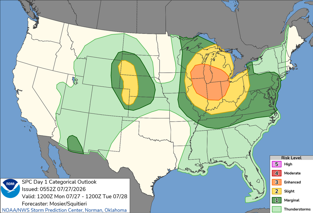
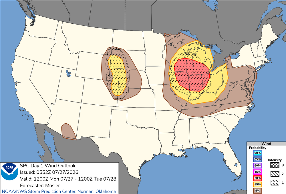
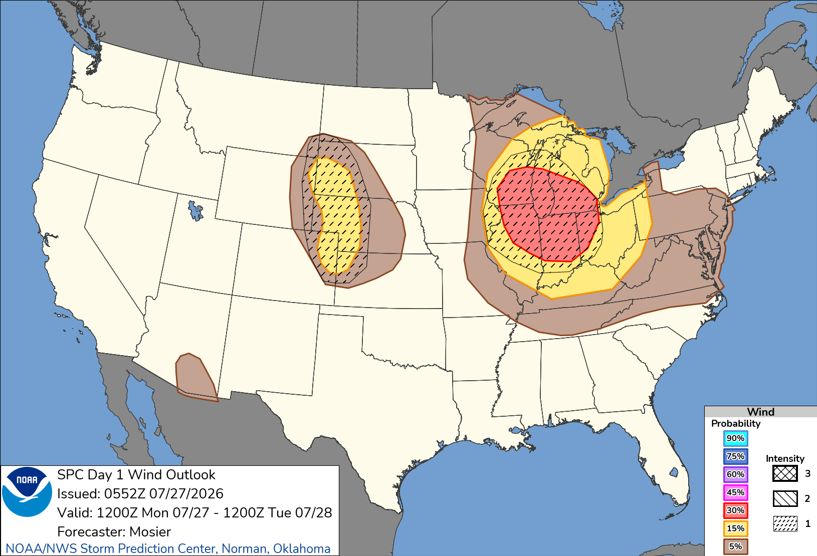
Marginal risk issued here with enh and slgt up north 2% tornado in north area 30-15-5% damaging wind with cig1 hatching also 15-5% hail risk also could have possible upgrades .
-
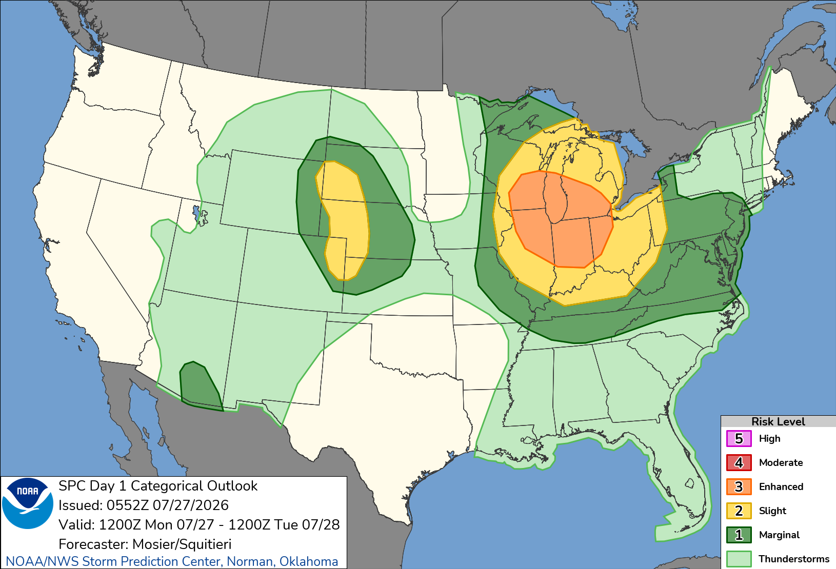
Going all in. If it happens I’ll start the first winter storm thread of the season. Potential for a destructive windbag/derecho Monday. SPC outlining a large Enhanced Risk area with SIG1 hatching. Potential upgrade to CIG2. Day 1 Convective Outlook NWS Storm Prediction Center Norman OK 1252 AM CDT Mon Jul 27 2026 Valid 271200Z - 281200Z ...THERE IS AN ENHANCED RISK OF SEVERE THUNDERSTORMS FROM PORTIONS OF THE UPPER MIDWEST/UPPER GREAT LAKES INTO THE OHIO VALLEY... ...THERE IS A SLIGHT RISK OF SEVERE THUNDERSTORMS ACROSS PORTIONS OF SOUTHWEST SOUTH DAKOTA...WESTERN NEBRASKA...NORTHEAST COLORADO...AND FAR NORTHWEST KANSAS... ...SUMMARY... Severe storms capable of strong to severe wind gusts and large hail are possible across the Great Lakes into the Ohio Valley Monday into Monday night. More sporadic occurrences of damaging wind appear possible in the Mid-Atlantic, Tennessee Valley, central High Plains, and southeast Arizona. ...Upper Midwest/Great Lakes into the OH/TN Valleys... A very moist airmass is in place from the Upper Midwest into the OH and TN Valley. This airmass is exists south of a diffuse cold front that extends from a surface low over far southeast Manitoba southeastward to far eastern Upper MI. One thunderstorm is currently ongoing near this boundary over eastern Upper MI. Most of the thunderstorms are ongoing just northeast another surface boundary demarcating the very moist (i.e. 70+ dewpoints) to it southwest. How this warm-air advection activity evolves early this morning will have a large impact on the severe potential farther downstream from the Mid MS Valley into the OH and TN Valleys through the late morning into the afternoon and evening. Much of the guidance is beginning to suggest the warm-air advection activity clusters early this morning over the MN Arrowhead vicinity before then tracking southeastward within the moisture/buoyancy gradient and organizing/intensifying significantly. Synoptically, the overall setup matches many characteristics of scenarios with strong, forward-propagating MCSs, including a surface boundary parallel to the deep-layer shear, at least modest mid-level warm advection, and very strong to extreme buoyancy. Given the trend within the guidance and favorable synoptics, confidence in the development of a strong forward-propagating MCS is high enough to adjust the 30% wind probabilities westward while also introducing a CIG1 area. There is a chance that both higher wind probabilities and a CIG2 may be needed, but predictability regarding convective evolution is too low at this time.