All Activity
- Past hour
-

2025-2026 ENSO
Stormchaserchuck1 replied to 40/70 Benchmark's topic in Weather Forecasting and Discussion
505dm over the Arctic circle today! It phases into a +NAO/+AO in the next few days, which is usual for the pattern this year since May. Cold +AO/+NAO H5 continues.. -
 Records: Highs: EWR: 100 (1993) NYC: 101 (1948) LGA: 99 (1948) JFK: 101 (1948) Lows: EWR: 52 (1940) NYC: 50 (1885) LGA: 55 (1940) JFK: 59 (1989) Historical: 1667: On this date one of the most severe hurricanes to ever hit Virginia reduced the Jamestown Colony to ruins. The nearest computation is that at least 10,000 houses were blown down. (pp 22-23 Washington Weather Book 2002 by Ambrose, Henry, Weiss) 1854 - A tornado struck downtown Louisville around noon on Sunday, August 27th, 1854. It first touched down near 25th Street, southwest of downtown and lifted at the intersection of 5th and Main Streets. Although the tornado was only on the ground for a little over two miles, the twister claimed at least 25 lives. Many of those who perished were killed in the Third Presbyterian Church, where 55 people were gathered for Sunday church services. Straight-line winds that accompanied the tornado did significant damage to the Ohio River, where at least one boat sunk. 1856: 3 inches of snow on peak of Mount Washington, NH. (Ref. AccWeather Weather History) 1881: A Category 2 Hurricane made landfall between St. Simons Island and Savannah, Georgia, on this day. Landfall coincided with high tide and proved very destructive. The hurricane killed 700 people, including 335 in Savannah, making it the sixth deadliest hurricane in the United States. 1883: Krakatoa Volcano exploded in the East Indies. The explosion was heard more than 2500 miles away, and every barograph around the world recorded the passage of the airwave, up to seven times. Giant waves, 125 feet high and traveling 300 mph, devastated everything in their path, hurling ashore coral blocks weighing up to 900 tons, and killing more than 36,000 persons. Volcanic ash was carried around the globe in thirteen days producing blue and green suns in the tropics, and vivid red sunsets in higher latitudes. The temperature of the earth was lowered one degree for the next two years, finally recovering to normal by 1888. 1893 - The first of three great hurricanes that year struck South Carolina drowning more than 1000 persons in a tidal surge at Charleston. (David Ludlum) 1893: An estimated Category 3 hurricane made landfall near Savannah, Georgia on this day. This hurricane produced a high storm surge of 16 to 30 feet which cost the lives of 1,000 to 2,000 people. As of now, this storm is one of the top 5, deadliest hurricanes on record for the USA. 1948: A late season heat wave was underway from parts of the Great Lakes, Ohio Valley to the Mid-Atlantic and Northeast. Other daily records included: Huntington, WV: 103°, Baltimore, MD: 102°, Cleveland, OH: 102°, New York (Central Park), NY: 101°, New York (Kennedy Airport), PA: 101°, Columbus, OH: 100°, Bridgeport, CT: 100°, Boston, MA: 100°, Portland, ME: 100°, Washington, DC: 99°, Richmond, VA: 98°, Buffalo, NY hit their all-time maximum temperature of 99 °F for August. (Ref. Many Additional Temperatures Listed On This Link) 1964 - Hurricane Cleo battered Miami and the South Florida area. It was the first direct hit for Miami in fourteen years. Winds gusted to 135 mph, and the hurricane caused 125 million dollars damage. (David Ludlum) 1965: Hurricane Betsy is born in the Atlantic. (Ref. AccWeather Weather History) 1970 - Elko, NV, was deluged with 3.66 inches of rain in just one hour, establishing a state record. (The Weather Channel) 1971: Tropical Storm Doria was moving up the East Coast. (Ref. AccWeather Weather History) (Ref. More Information About Doria) 1973: Largest hailstone ever recorded in Canada hit Cedoux, Saskatchewan. This stone was 4.5 inches in diameter and weighed a pound. (Ref. AccWeather Weather History) 1986: August snow in Michigan ? Not much, but it did happen. Weather observers in Gwinn and Negaunee noted a few snow pellets mixed in a rain shower. In Sault Ste. Marie, a mix of snow and rain was the first observed August snow since records began in 1888. (Weather Guide Calendar with Phenomenal Weather Events 2011 Accord Pub. 2010, USA) 1987 - Washington D.C. soared to a record hot 100 degrees, while clouds and rain to the north kept temperature readings in the 50s in central and southeastern New York State. (The National Weather Summary) 1988 - Afternoon thunderstorms produced locally heavy rains in the southwestern U.S. Thunderstorms in eastern New Mexico produced wind gusts to 75 mph near the White Sands Missile Range, and produced three inches of rain in two hours near the town of Belen. (National Weather Summary) (Storm Data) 1989 - Afternoon and evening thunderstorms produced severe weather in southeastern Nebraska, eastern Kansas and Missouri. Thunderstorms produced baseball size hail south of Belleville KS, and tennis ball size hail south of Lincoln NE. Thunderstorms produced golf ball size hail and wind gusts to 70 mph at Saint Joseph MO. Thunder- storms in North Dakota deluged the town of Linton with six inches of rain in one hour. (The National Weather Summary) (Storm Data) 1990: New York City had a bout of severe weather. The Bronx received 4.24 inches of rain. A wind gust of 61 mph moved through LaGuardia Airport. At Nassau, 12 people were injured from an overturned boat. (Ref. AccWeather Weather History) 1994: The "Big Flats Tornado" was a F3 tornado as it rolled through the town of Big Flats, WI and caused $1 million dollars in damage. 24 homes were destroyed, eight suffered major damage, and 160 had light to moderate damage. In addition, the Big Flats Fire Department and town hall were destroyed, as well as a thrift shop. 70 cows were crushed to death in one barn as the walls blew out and the upper floor, filled with 16,000 bales of hay, and the roof collapsed. This was one of the first tornadoes detected by the new WSR-88D installed at Sullivan, WI. In addition to this tornado, two other F1 tornadoes touched down on this date just south of Lyndon Station, WI and just southeast of Plainville, WI. (Ref. Wilson Wx. History) 1995: 17.01 inches of rain fell at Antreville, SC from the remnants of Tropical Storm Jerry, setting a new 24 hour rainfall record for the state. 12.32 inches of rain fell at Greer, SC from the remnants of Tropical Storm Jerry, setting new 24 hour rainfall record for Greer. (Ref. Wilson Wx. History) 1998: Hurricane Bonnie passed just east of Cape Fear, NC late on the 26th and made landfall near Wilmington, NC on the 27th as a Category 2 hurricane. Bonnie would be the first of 7 (3 hurricane and 4 tropical storms) named tropical systems to make landfall in the United States during the very busy hurricane season of 1998 (the most since 1985). The final bill: $720 million in damage. 3 people were killed by the storm. One of the biggest victims of Bonnie was the tourism industry in eastern North Carolina. The storm forced over 500,000 visitors to flee in advance of the storm. (Ref. AccWeather Weather History) 2002: A stationary thunderstorm over the foothills of the Bighorn Mountains in Wyoming produced rainfall totals of up to 7.4 inches in six hours. The excessive rains produced severe flash flooding that damaged most of the homes and businesses in Kaycee, WY. As bad as the damage was, experts say that if the rainfall had been centered 10 miles further north, the town of Kaycee would have been totally destroyed. Severe thunderstorms spread large hail over metro Denver, CO. Hail up to two inches in diameter fell in Jefferson County 5 to 11 miles northwest of Golden. A storm produced a trace of rain and a microburst wind gust to 52 mph at Denver International Airport. (Ref. Wilson Wx. History) 2003: Southern Michigan to Washington, DC on August 26th and 27th: A derecho associated with a cluster of severe thunderstorms affects parts of Michigan and states eastward to Washington, DC. Strong winds leave hundreds of thousands of customers without electrical power, just weeks after the Great Blackout of 2003. (Ref. WxDoctor) 2005: Hurricane Katrina reached Category 3 intensity in the Gulf of Mexico about 335 miles south-southeast of the mouth of the Mississippi River with maximum sustained winds of 115 mph. 2009: New London, Iowa: In New London in southeast Iowa's Henry County, 8.34 inches of rain fell---7.20 inches of it in just four hours. (Ref. WxDoctor) 2011: Irene made landfall Saturday morning at Cape Lookout, N.C. — a bull's-eye in the field of weather forecasts. The high wind gust today was 52 mph at 17:53 hours and new record wind speed for this station. (Records since September 2008) The Richmond International Airport recorded a wind gust to 71 mph. The Richmond International Airport highest gust during Isabel was 73 mph. Irene was certainly the worst wind storm since Isabel for the Richmond area and about 75 percent of the Richmond area is without power. The West Henrico Co. - Glen Allen VA. total rainfall today was 3.75 inches a calendar day record rainfall for this station. (Records since August 2008) The precip. for today was 0.08 inches & for Aug. 6.65 inches and the average precipitation to Aug. 28 is 3.69 inches giving a departure of + 2.96 inches. The storm total was 3.83 inches and 24 hour total which sets a new record for the most precipitation in 24 hours. (Records since August 2008) Also two large trees down in our neighbors yard.(The West Henrico Co. - Glen Allen VA. Weather Station) (Ref. The Weather Nut - NWS at Wakefield - See Map of Irene's Track ) 2013 - Numerous severe thunderstorms brought large hail along with wind gusts from 60 to 90 mph to parts of north central and northeast South Dakota. Numerous trees were downed along with many structures damaged. Eighty mph winds near Polo in Hand County snapped off two large cottonwood trees. Ninety mph winds snapped numerous trees off at their base along with destroying a garage and tipping several campers over onto their side at Cottonwood Lake near Redfield. 2017: Harvey was a Category 4 hurricane at its peak. It has since been downgraded to a tropical storm. But the hurricane scale is based on wind speed, not volume of water, and Harvey has continued to funnel tremendous amounts of moisture into Texas. As homes across the metro region filled with waist-deep water, rescuers scoured flooded inner city streets and subdivisions in kayaks, fishing boats and inflatable rafts, plucking families to safety. “Hurricane Harvey has effectively turned south and central Texas into a lake the size of Michigan,” Brad Kieserman, vice president of disaster operations and logistics for the Red Cross, told NPR. “This is as catastrophic as you could possibly imagine from a Category 4 storm.” (The NWS said Monday the 28th that parts of Harris County had seen 30 inches of rain.) (15 inches of rain and more to come) (Harvey made landfall near Rockport, Texas) (Satellite-before-Landfall on the 24-25 landfall near Rockport, Texas) 2020: Hurricane Laura moves In land(Ref. NWS and Radar by Weather Underground ) (Ref. CNN -Cat 4- Hurricane - Wind Damage Severe )
 -

2025 Atlantic Hurricane Season
BarryStantonGBP replied to BarryStantonGBP's topic in Tropical Headquarters
should have gone to specsavers lad waters in the gulf and wcar are warm keep dreaming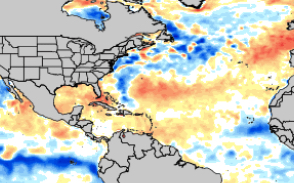
-

Mid to long range discussion- 2025
WinstonSalemArlington replied to wncsnow's topic in Southeastern States
What the helly, GFS?! -
 i just want a cool spell that matches the warm ones. top 5 cold august when?
 -
Dew point here at 48, I love it outside doing garden and yard work, feels awesome ! Meanwhile, way up North they are setting records for all-time warmth for this time of year.
-
Makes me wonder if CC is beginning to give us distinct wet and dry seasons, like most of the world. I think we're somewhat unusual in that historically we don't really have a whole lot of difference between our wettest and driest months (30% or so variation). We'd be joining the ranks of the West Coast...all locations within the annual ITCZ oscillation (tropics)...Mediterranean basin...South Asia...the list goes on. Maybe then we'd adopt more awareness and proactivity about water management and conservation, like West Coast folks who have had to factor water use into their planning for so many things in life.
-
yeah it was always a front I guess. A few Euro runs from a couple days ago had the low further south and better lift here, and that has trended north. Loosely reminded me of recent winters where clippers seem to like NNE or southern canada the best.
-

Mid to long range discussion- 2025
SEwakenosnowforu replied to wncsnow's topic in Southeastern States
Uggg...less hope winter does not turn out like the winter following August 2004....Nothing but cold rain and CAD ice (mostly minor). Only real snow was eastern & coastal NC in December. -

2025-2026 ENSO
PhiEaglesfan712 replied to 40/70 Benchmark's topic in Weather Forecasting and Discussion
With Beryl, we were still in early July, and had a lot of hurricane season left. We're now at about the time of the season of Andrew and Felix, in 1992 and 2007, respectively. I'm pretty sure people thought there would be more major hurricanes after that point, especially after Felix in 2007 with a developing strong la nina. Point is, you just never know. Yes, there will be more storms, but as we saw in 1992 and 2007, it's very possible that none of them are major. -
Just a reminder for the general audience: The correct interpretation of this chart above is 'there's a 60 to 70% chance for warmer than normal' Note, +.01 is warmer than normal. Frankly, if I'm asked ( which I am not ... understood ha ), after looking over the charts and indices therefrom I'm not seeing anything wholly convincing for warmth to be honest. Can it change? Obviously yes. We have to give a lot of latitude to the indicators and modeling trends at this time of year. As is typically the case, the flow behavior has become nebular in structure; it's not really easy to assess where the major forcing structures will be located in space and time, as model to model variation places that stuff inconsistently. In fact, that uncertainty is even more so than normal from what I am seeing. There's polar jet that keeps trying to orient into a winter like pattern up across Canada, replete with repeating model runs drilling diving jet through Ontario and killing any hope for warmth here through ...D10 or 11... Meanwhile, there's this weaker meandering S jet with nondescript wave signature rippling across 35 N... These two jet regions are challenged to find one another and sync up, as they should be at this time of year... It's basically a couple of hoses flopping around in the guidance. Once every 7 or 8 model cycles, they phase - like the 00z Euro with an autumn trough through the Lakes at 252 hours. Or the previous 18z GFS from yesterday, having a WAR like end of run... Neither of these are likely sustainable indicators though. They'll either disappear or morph so much the implications change. It looks likes like the first 10 days to two weeks of the month will be crushingly uneventful with exceptionally loud silence. haha
-

Mountain West Discussion
mayjawintastawm replied to mayjawintastawm's topic in Central/Western States
APA (Centennial Airport) is at 0.30" for the month, which I think is pretty typical for the immediate I-25 corridor (say 10 miles either side) north of Castle Rock. We're at 0.36" at my house. -
More eastern shore sites coming this week!
- Today
-
Mountain West Discussion
mayjawintastawm replied to mayjawintastawm's topic in Central/Western States
Beautiful fire prevention!! -
Not that I want H hits in the SE because I don’t as I’d love a boring shutout! But keep in mind that the lowest August temp since 2001 in RDU, GSO, ATL, and most major stations in TN/NC/SC/GA and some in AL was in early to mid August of 2004. That month had a 2-3 week long stretch of BN temps. The very next month had 3 bad hurricanes hit FL.
-
That was for SouthCoastMA and the clipper reference.
-
Don’t forget that August of 2004 had 2-3 weeks straight of BN.
-
46.4 this morning. Hopefully we don't pay for this in October.
-
Was 50 for the morning walk out of Monkton station with the dogs at 7 am.
-
Keep in mind that the lowest August temp since 2001 in RDU, GSO, ATL, and most major stations in TN/NC/SC/GA and some in AL was in early to mid August of 2004. The next month had 2 bad hurricanes hit the FL E coast and 3 in total in addition to Charley in that same August.
-
In 2025, one can just make something up, post it on social media, and others will believe it. Obviously, the Carr Fork Lake number is erroneous, and the 2012 occurrence at Greenup looks to be an error as well. In 1986 and 1946, clearly a number of stations observed lows in the 30s in Kentucky. In August 1986, nearly 1/4 of all NWS stations in the State had a low in the 30s. And this is just official cooperative stations, not backyard thermometers or mesonets or whereever that is sourced from. Kentucky's highest point is 4,145 feet. Those elevated valleys in the east can radiate well.
-
Models seem to create their own triggers sometimes… Probably just emergence of chaos in the model as it processes out in time. If the layout is numerically/physically unstable as an initial condition and then the model plunks down one of its little invented triggers in the midst of it we’re going to get these weird solutions like that faux “Bob“ thing … Along with a lot of posts about why it’s possible ha ha ha
-
I would tend to think right now that the ACE finishes lower than the 161 reading we got for 2024. But there are some similarities to last year so far. 2024 featured hurricane Beryl going CAT 5 in early July. Then no major hurricanes until late September. This year we got the CAT 5 Erin in mid-August and now it looks like perhaps no majors into at least mid-September. So my guess is that Erin won’t be the only major this year.
-
51.7 IMBY this morning. I was up at Fall Creek Falls Monday and Tuesday. I'm not sure what the low temp was Tuesday morning, but it felt like upper 40's. Excellent running weather.
-
Of note that 45.9 degree low temperature this morning at Warwick Township is the 2nd coldest temperature recorded in the county on this date behind only the 42 degree low back in 1944 at Phoenixville.


