All Activity
- Past hour
-

January 25-26 Winter Storm Potential
mattinpa replied to Ralph Wiggum's topic in Philadelphia Region
Yes we don’t have much more wiggle room before sleet comes into play. Hopefully just an overdoing it by the CMC and UKMet. -

Pittsburgh/Western PA WINTER ‘25/‘26
Rd9108 replied to Burghblizz's topic in Upstate New York/Pennsylvania
Thanks for sharing and sorry for your loss. Thats bring this one home for her. Wow imagine if this ends up sleet here lol. -
Primary gets to the PA border but coastal saves our bacon
-

Pittsburgh/Western PA WINTER ‘25/‘26
Burghblizz replied to Burghblizz's topic in Upstate New York/Pennsylvania
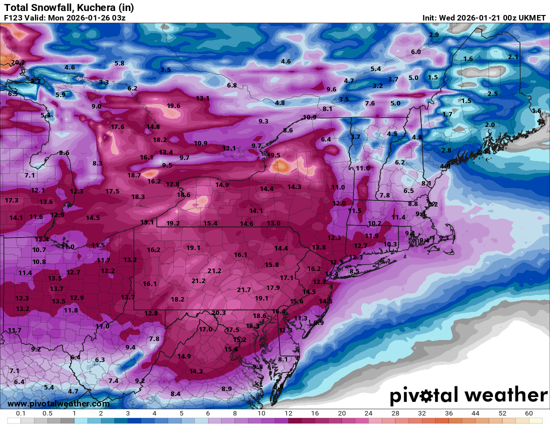
Anyone have Ukie Kuchera just for fun. Thats likely way over amped (I doubt it drizzles Sunday). But I bet that’s a nice 15”+ before that. -

January 25-26 Winter Storm Potential
LVblizzard replied to Ralph Wiggum's topic in Philadelphia Region
It doesn’t want to fully transfer the primary low at all. It just keeps going with it until it’s in upstate NY and pushes the high out of the way like it’s nothing. Not really buying that. -
Dont look at UKIE
-

Possible Record Breaking Cold + Snow Sunday 1/25 - Tuesday 1/27
jdj5211 replied to TriPol's topic in New York City Metro
. -

Winter 2025-26 Medium/Long Range Discussion
Cary67 replied to michsnowfreak's topic in Lakes/Ohio Valley
When the Euro shows rain in the OV as SLP moves from Terre Haute to Indy line then start a thread -

January 2026 regional war/obs/disco thread
rimetree replied to Baroclinic Zone's topic in New England
Loaded pattern. Nice eye candy on the ops. -

Possible Record Breaking Cold + Snow Sunday 1/25 - Tuesday 1/27
eduggs replied to TriPol's topic in New York City Metro
Flips back to snow on the UK. Wild solution. Can't completely discard it though. Shift that a little less amped and you have a great long-duration event. -
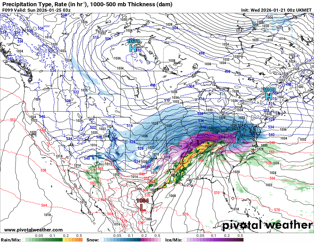
The UKIE is like "hey, let's have a severe thunderstorm outbreak mid winter storm as I cut due north and flood 50s into Tennessee!"
-

Possible Record Breaking Cold + Snow Sunday 1/25 - Tuesday 1/27
Jt17 replied to TriPol's topic in New York City Metro
That's a pretty weird .3-.4 missing qpf blob for NYC too lol nice weird run . -
The reactive emotional roller coaster some weenies ride is completely nauseating
-
We are quickly turning to putting our eggs back into the GFS basket though
-

Possible Record Breaking Cold + Snow Sunday 1/25 - Tuesday 1/27
Stormlover74 replied to TriPol's topic in New York City Metro
Even if it ends as sleet after this falls
-
I'll wait for the next two runs of models to see if this was a 'blip', but yeah.
-

January 2026 regional war/obs/disco thread
40/70 Benchmark replied to Baroclinic Zone's topic in New England
With primary that far N? Seems wonky... -
I definitely agree with you, but I don’t understand why you assume it’s going to keep happening. It is slightly concerning because it’s the Ukie which i believe has the second best verification numbers, let’s see what the Euro says in 45 minutes.
-
I am too. I mean this is Tuesday...this thing has enough time to trend all the way to mostly sleet at this rate!
-

January 2026 regional war/obs/disco thread
OrangeCTWX replied to Baroclinic Zone's topic in New England
Drunk uncle sure did make an appearance on that run lol -

Richmond Metro/Hampton Roads Area Discussion
RVASnowLover replied to RIC Airport's topic in Mid Atlantic
Do I wanna put myself through the torture of staying up for EURO? -
Epic sig material
-

Possible Record Breaking Cold + Snow Sunday 1/25 - Tuesday 1/27
SACRUS replied to TriPol's topic in New York City Metro
UKMET 00Z Total QPF -

Pittsburgh/Western PA WINTER ‘25/‘26
colonel717 replied to Burghblizz's topic in Upstate New York/Pennsylvania
Ukie. Ends as drizzle here. Crazy.
-
Like the CMC, Ukie begins to change to sleet around midday over DCA, but not much precip after that. Almost like ending as a period of sleet that lightens up quickly by mid/late afternoon. Still a nice front end THUMP before that. Considering how intense that front end WAA snow is...I'll take it. Notice the low in WV by 18Z Sun. Yeah, not the kind of Miller B you want, but again, this would be one hell of an acceptable front-end thump.
.thumb.png.5391cd2fc10b3bc56f250181b3d548d2.png)


.png.2826bde069d48363dd9b50866389bfa3.png)