All Activity
- Past hour
-
Not really, there is something called seasonal lag, which is why the hottest days on most years are deep into July, sometimes in early August. Besides, the days have noticeably stopped getting longer, especially on the morning side. At night, it is still getting light later. By around June 13-14, most places in this area will have seen their max daylight (it might still be technically getting longer by a second or two, but that's junk change when you have 15 hours of daylight), and that will go on until about June 26-27.
-
I actually drove right by KBED yesterday. This makes sense as many many sneezes were had.
-
Wtf. This is getting annoying Sent from my SM-S921U using Tapatalk
-
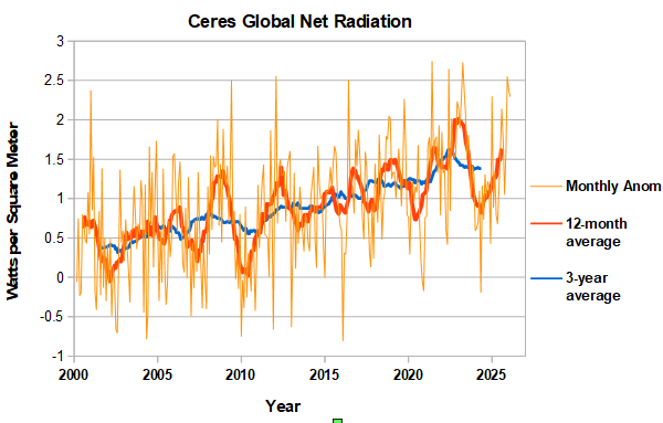
CERES net radiation through March. At high level in March, similar to February. Probably close to peak for this ENSO cycle.
-

2026-2027 Strong/Super El Nino
snowman19 replied to Stormchaserchuck1's topic in Weather Forecasting and Discussion
Latest SOI: -35.29 In other news, this El Niño has become severely east-based. There are confirmed, historic anomalies of +7.2C off the coast of Peru in region 1+2, which is a new all time record, surpassing both 1997 and 1982. And as @Gawx predicted, very rapid warming of the SSTs in region 3.4, OISST ONI: +1.2C, RONI: +0.73C. With this major WWB ongoing, it would not surprise me if we are into a high-end moderate/strong Nino (RONI/ONI) by the end of this month -
- Today
-

Central PA Summer 2026 Discussion/Obs Thread
mahantango#1 replied to Voyager's topic in Upstate New York/Pennsylvania
US National Weather Service State College PA Thursday - June 4, 2026 @ 430 AM EDT: High pressure drifting by just to the south of PA today will bring mainly sunny and warm conditions with comfortable/low humidity for our Thursday. The peak in temperature and heat indices will occur Friday with humidity creeping up a bit. Increasing west to southwesterly winds at the surface and aloft Saturday will combine with warm temperatures, higher humidity and an approaching cold front to bring scattered strong to potentially severe thunderstorms in the afternoon and evening. -
Central PA Summer 2026 Discussion/Obs Thread
mahantango#1 replied to Voyager's topic in Upstate New York/Pennsylvania
-

2026-2027 Strong/Super El Nino
TriPol replied to Stormchaserchuck1's topic in Weather Forecasting and Discussion
Save it for October! -

2026 Atlantic Hurricane Season
WxWatcher007 replied to Stormchaserchuck1's topic in Tropical Headquarters
We will see if the signal becomes more consistent in the coming days, but today was really the first where we saw a stronger signal for TC genesis in the Gulf across operational and ensemble guidance near that mid-month window. -
2026 Atlantic Hurricane Season
WxWatcher007 replied to Stormchaserchuck1's topic in Tropical Headquarters
Going with 9/4/2 -
2026 C and E Pacific tropical activity
WxWatcher007 replied to GaWx's topic in Tropical Headquarters
Models are starting to light up in the EPAC I’m the coming days. A fast start seems increasingly likely there. -

Junorch obs and discussion 2026
TheClimateChanger replied to Damage In Tolland's topic in New England
Just a touch of some Canadian smoke aloft it looks like. -
If the thunder don't get you than the lightning will.
-
 Drivers of primary patterns take time to manifest because they become stable and promote large scale changes across the globe. The teleconnections are a case of drivers, but some last longer than others, so temporal variance is lower in more stable regimes. ENSO takes time to promote atmospheric coupling, so we usually see lags that can last months before the regime takes a greater hold on the overall global pattern. You also have your seasonal variances in the mix too, especially this time of year where the tropics begin activating with a series of waves and focus of trade wind flow stemming from hemispheric drivers like the development of the Bermuda High and Eastern Pacific ridging that takes shape as we see increasing heat flux across the Desert Southwest with a Monsoonal trough materialize due to topographic schemes coupling with intense continental heating. All of this to say; it takes time and pattern shifts also yield different results pending other variables that can be found during intra-seasonal transition and fluctuations within other teleconnections globally. Persistence usually wins out in the long term, but one stable pattern eventually does give way after a while when in the right scenario. This time, it will with ENSO’s transition to more El Niño composites, so it will only be a matter of time before the pivot. Right now, it’s not trending significantly in that direction the next few weeks, but you might start seeing signs of subtle shifts in the coming 2-4 weeks. I think a full hemispheric deviation won’t occur until later in the summer or fall. Just my 2cents.
 -
Love it! Ill be in Alaska
-
If you use that true color overlay and go earlier in the day, I swear you can see waves pulsating over the northeast/rust/mid atl. Might have to zoom way in. Yes, I'm sober.
-
not bad. Grilled some chicken and ripping back a drink

-
I think last year will continue to show up
-

Central PA Summer 2026 Discussion/Obs Thread
Mount Joy Snowman replied to Voyager's topic in Upstate New York/Pennsylvania
My P&C has me failing to reach 90s tomorrow and Sunday and has me in the 70s both Monday and Tuesday, so we shall see. But yes longe range looks warm. -
83 high 49 low . 44 low at Frederick
-
We’ve seen them climb the 5-foot retaining wall to get into the Gondola barn and then remove the storage door, hinges and all, just to get to a bucket of compost.
-
72/49, clear sky full of stars, what an amazing evening outside on the back patio tonight !
-

Mountain West Discussion
mayjawintastawm replied to mayjawintastawm's topic in Central/Western States
We've had just fringes of things here, no hail and 0.11" rain since Monday. -
 That's a question for @WxUSAF or @MillvilleWx as they understand how atmospheric forcing causes pattern changes. I am at the point where I can tell you the pattern to look for and if models show it.


.thumb.gif.f92b16c631a1d15d405ed77b33f0710d.gif)