All Activity
- Past hour
-

E PA/NJ/DE Winter 2025-26 Obs/Discussion
RedSky replied to LVblizzard's topic in Philadelphia Region
Dont forget Larry Cosgrove -

Dec 6-7th (It's not a clipper) Clipper
frostfern replied to Chicago Storm's topic in Lakes/Ohio Valley
Nov-Dec 2000 was huge IMBY. System snow and lake effect. Dec 2008 was also very memorable, though the pack melted fast during the holidays with a lot of rain. 2008-2009 was a wet one with both rain and snow. -
30.6 with a 100% humidity. I checked Newport News INTL they also have a 100% humidity. That's bizarre. The sky is clear.
-
Also got down to -5 here. NWS reported a wind chill of -13 which my brief walk outside confirmed. Nasty cold.
-

December 2025 regional war/obs/disco thread
WinterWolf replied to Torch Tiger's topic in New England
Perfect post. December…for the most part sucks for snow in SNE. Sure, we’ve had some good ones. But way more bad ones. That’s just how it goes in SNE. The cold is in place…we may hit on something yet. But it’s nothing unprecedented if we don’t. Ya, we’ll waste a good cold pattern…but that’s happened about a thousand times before also. As Powderfriek said…it ebbs and flows. SNE was killing it for a good long while, it’s a bitch when you go back to the shit barrel. But we knew it was coming. Now we need a good double or triple to break us out of the slump, we’ll get it. -

December 2025 regional war/obs/disco thread
Typhoon Tip replied to Torch Tiger's topic in New England
another in a parade of phantoms -
Anybody notice how far south the Wed shortwave has gotten on the GFS? It gets the 500mb 540dm contour all the way down into the Carolinas this run (0z). It's been steadily shifting south for maybe a half dozens runs now. It probably doesn't mean much given the relative short range (and lack of support)... but any further south and northern parts of the region would be in the game for some wintry precip. The Poconos are already in the game. I-84 region is borderline.
-
Do you see any decent winter weather opportunities for the southern plains moving forward?
-
This might wake a few folks up. Long way to go, but nice to see...
-
Dude, was driving back just now from Richmond to Charlottesville and it was thick as pea soup out there. Never seen it that bad....whole dang way home
-
Gfs shows a snowstorm for the 16th even down to the coastal plain.
-
30.6, GFS still has 2-3 inches here.
-
Eyeballing about 1.5”. Had snow on and off for a good part of the afternoon and it became steady later in the day, ending with a heavier burst. I think there is 6”-8” on the ground now. It is enough to buzz the snowmobiles around the yard for a bit. Down to 15.2°.
-

E PA/NJ/DE Winter 2025-26 Obs/Discussion
PhiEaglesfan712 replied to LVblizzard's topic in Philadelphia Region
Just look at the storm tracks, and all the sharp cutoffs south and east. It's been a recurrent theme since 2016-17 (with the exception of 2017-18 and January 2022.) If you live in a coastal area, like Atlantic City, you're not going to see much snow this year. -
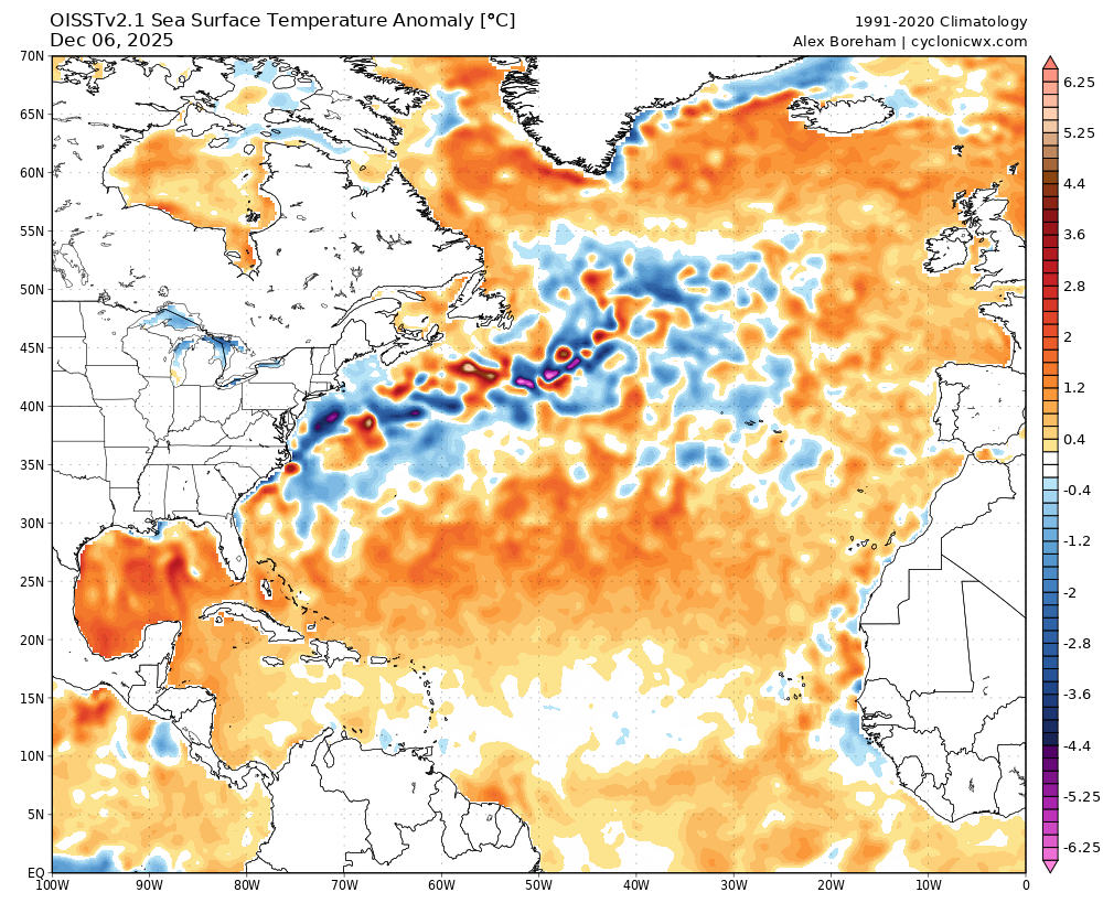
Odd. Oisst shows it predominantly below normal as of 12/6. Something isn't right, not that it matters.
-
You betcha. The western ridge is semipermanent. Cold air will continue along with storm after storm after storm after storm after storm after storm after storm after storm after storm. Snow gods love the Mid Atlantic this winter. You will all see soon enough! ENJOY! Bob Chill I hope you get buried alive by fluffy snow!
-

Dec 6-7th (It's not a clipper) Clipper
michsnowfreak replied to Chicago Storm's topic in Lakes/Ohio Valley
They were. But still picked up 25.1" in December 2000. I had 29.9". -

December 2025 regional war/obs/disco thread
WxWatcher007 replied to Torch Tiger's topic in New England
GFS now following the NAM with a little snow early Wednesday in SNE. -
28.2/26.5 at 11 pm, plenty cold enough for snow.
-
Sure, Where you are is, As a whole area, NNE is not crushing it, Not sure what the creiteria is for a crushing, The rest of NNE outside of elevations has 4-8" on the ground but it has been plenty cold and building ice, Way ahead of last year in that dept.
-

December 2025 regional war/obs/disco thread
powderfreak replied to Torch Tiger's topic in New England
-11.6 in the first full week of December is a significant departure for MVL locally. That doesn’t happen often. It’s been cold. BTV is -11.3 to start December. For a location that seems to run warm. -

Richmond Metro/Hampton Roads Area Discussion
migratingwx replied to RIC Airport's topic in Mid Atlantic
00z GFS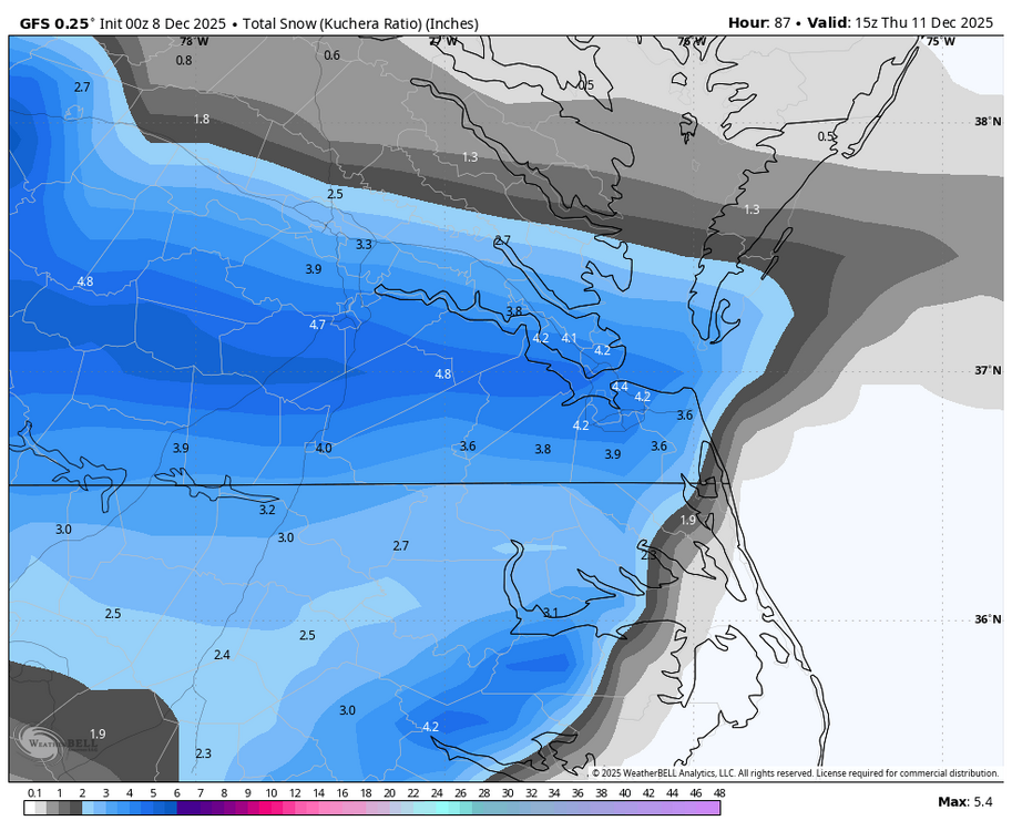
-

The Monday wintry event potential (12/8/25)
kvegas-wx replied to GaWx's topic in Southeastern States
Just need some moisture here in the Triad. Already 2° colder than modeled at 33°. We could sneak down to freezing soon with no cloud cover. Don't you Virginia boys wreck a forum party! -
33.6/33.13 at 10:54p.
-
It should be if there is a warmup. Lag in the MJO would put us near the holidays.