All Activity
- Past hour
-
I like this window, think we’ll be tracking something. i liked this weekends window 12-15 days out and that’s turning out ok, lets get on a heater.
-
Only for it to go from 16 inches of snow to freezing rain in 24 hours 3 days out.
-
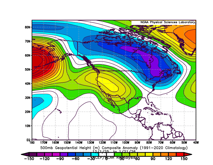
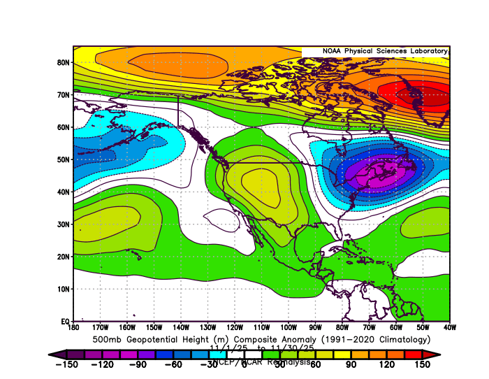
This has been one of the rare instances of significant features of the winter 500 mb pattern becoming established in November.
-

January 24-26: Miracle or Mirage JV/Banter Thread!
mattie g replied to SnowenOutThere's topic in Mid Atlantic
Hate to say it, but I'm beginning to lose interest in this storm. It'll be cool when the snow comes in hot and heavy, but it'll flip during the day on Sunday, which kinda sucks (rather it flip at night if it's going to flip at all). Also doesn't help that we've been tracking this thing for like a week and we've seen such drastic changes for the worse over the last few days. I'm already looking forward to the next big-dog window, so at least there's that! -

January 2026 Medium/Long Range Discussion
NorthArlington101 replied to snowfan's topic in Mid Atlantic
Congrats VA/NC border -

Pittsburgh/Western PA WINTER ‘25/‘26
TimB replied to Burghblizz's topic in Upstate New York/Pennsylvania
The Canadian is even more absurd. 3 feet in Louisiana. -
-
make that two!
-

Snow Contest January 25th-26th
WeatherGeek2025 replied to WeatherGeek2025's topic in New York City Metro
saturday 5pm tomorrow -

January 2026 regional war/obs/disco thread
mahk_webstah replied to Baroclinic Zone's topic in New England
Which could mean north trend? -
January 2026 Medium/Long Range Discussion
NorthArlington101 replied to snowfan's topic in Mid Atlantic
CMC is really weird. Kinda shreds the storm in half and is now pummeling VA beach/NC -
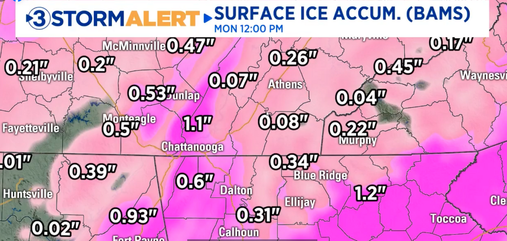
OBS right now,CF moving through Tn
-

January 25/26 Jimbo Back Surgery Storm
Brick Tamland replied to Jimbo!'s topic in Southeastern States
Problem is they still have a lot of freezing rain, too. -

“Cory’s in LA! Let’s MECS!” Jan. 24-26 Disco
RUNNAWAYICEBERG replied to TheSnowman's topic in New England
This would have turned into a cutter last 4 winters so yea, times be changing… -

January 2026 regional war/obs/disco thread
dendrite replied to Baroclinic Zone's topic in New England
Congrats Atlanta. Ptype loop looks like Mar 93 going across the SE -
Needs to be 50 miles further east. Canadian is perfect for SEVA
-

January 25/26 Jimbo Back Surgery Storm
NorthHillsWx replied to Jimbo!'s topic in Southeastern States
On my way to the new storm thread -

Possible Record Breaking Cold + Snow Sunday 1/25 - Tuesday 1/27
Nibor replied to TriPol's topic in New York City Metro
GFS and CMC around FEB 2 -
That second GFS storm is an absolute titan, Cat 5 NESIS/RSI type stuff.
-
Its over for us around 252... but since its 30 hours I cant do a PW 24 hr snapshot... but sounds right
-
Low moves 350 miles south. No wonder we are so hamstrung by our “tools”
-

January 2026 regional war/obs/disco thread
ORH_wxman replied to Baroclinic Zone's topic in New England
We’re getting a pseudo El Niño pattern in a Niña February. That is so weird to see on all the guidance. -

Possible Record Breaking Cold + Snow Sunday 1/25 - Tuesday 1/27
SACRUS replied to TriPol's topic in New York City Metro
1/23 12z UKMET Total QPF storm Total Snow / Sleet Frz rn (10:1) -
i read you stuff man..you like those big Os right there lol?
-
Start the thread! (But wait till Feb 1)


