All Activity
- Past hour
-
(002).thumb.png.6e3d9d46bca5fe41aab7a74871dd8af8.png)
E PA/NJ/DE Winter 2025-26 Obs/Discussion
ChescoWx replied to LVblizzard's topic in Philadelphia Region
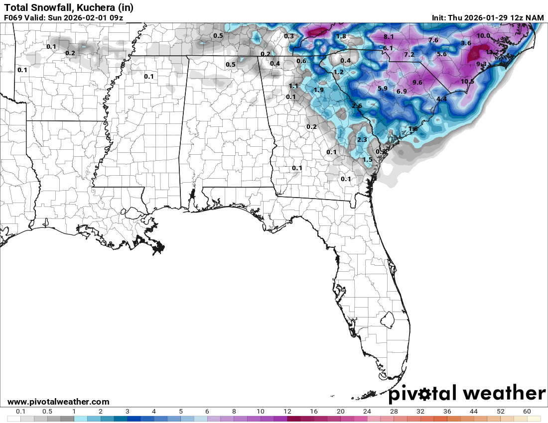
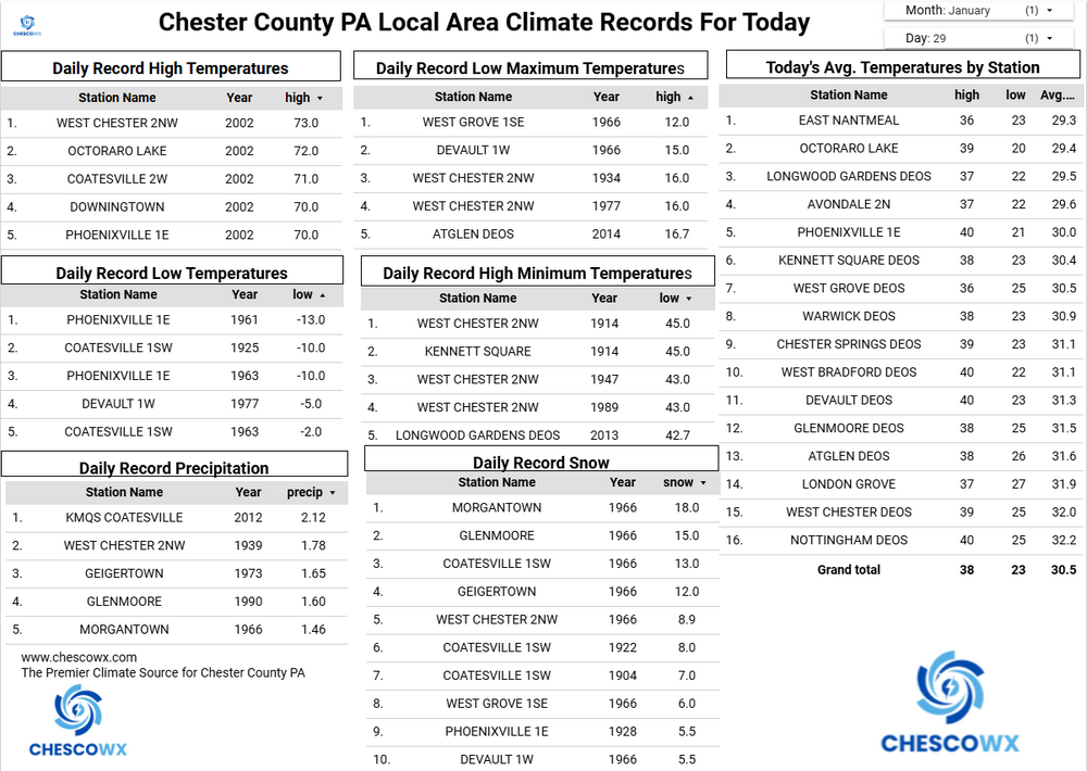
Well, most spots stayed above zero including here in East Nantmeal where our low was 5.5 above zero. A couple of our network stations reached below zero with both Warwick Township (-6.5 below) and Nottingham (-0.3). A reinforcing shot of arctic air arrives later today so the NWS continues to have most spots with below zero low temperatures again tonight and Friday night. The coastal storm this weekend continues to look likely to stay far enough southeast of our area to give us no more than flurries. Any potential snow accumulation looks to be confined to the shore points. Either way our persistent cold pattern looks to continue for the foreseeable future. In fact, the longer-range ensemble models have us staying below freezing both day and night through at least mid-February! This if it occurred may be one of our greatest sustained cold periods on record with data back to 1894. I will need to do a little digging on that one. Either way stay warm!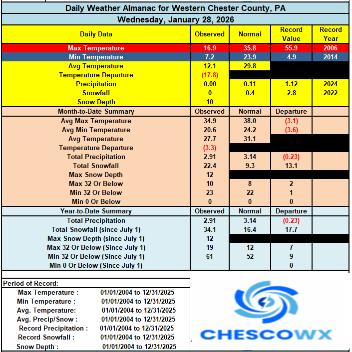
-
Richmond Metro/Hampton Roads Area Discussion
Berlin1926 replied to RIC Airport's topic in Mid Atlantic
This seems very sensible. DTs first call appears on track. Sent from my SM-S928U using Tapatalk -

The “I bring the mojo” Jan 30-Feb 1 potential winter storm
PeeDeeWx replied to lilj4425's topic in Southeastern States
Confused why folks are upset of the latest NAM?
-

Richmond Metro/Hampton Roads Area Discussion
Ephesians2 replied to RIC Airport's topic in Mid Atlantic
We are getting most of the trends we want at 500mb but it looks like we have another low developing way offshore robbing moisture from the main one -

Arctic Hounds Unleashed: Long Duration Late January Cold Snap
dendrite replied to WxWatcher007's topic in New England
-10ish down the road in the valley again…pushed -15 over by Winnisquam. Min was -1.7 here. Years ago that would’ve pissed me off, but now we take. -
Butler I would say 45 inches.
-

Possible coastal storm centered on Feb 1 2026.
Typhoon Tip replied to Typhoon Tip's topic in New England
I actually agree with this sentiment ...wrt to just this 12z run, sure - The system's close 531 dm actually encases the whole region with some E component at that 500 mb initiated. The QPF paint on the actual surface chart looks dubiously broken apart. This is a very large system. It's possible in fact probable that the there'll be an extended quasi CCB arc out farther than the typical size one may be used to seeing. I mean I'm not trying to gaslight anyone into thinking but this arc could be more formed than what we are seeing here - if having the visual example helps ... -

Possible coastal storm centered on Feb 1 2026.
TauntonBlizzard2013 replied to Typhoon Tip's topic in New England
That’s why I’m so confused at these posts. Look at the gradient. Wherever it is. I don’t see anything other a massive precip field moving over the region. It’s a pretty narrow area, for those that get into it. Some of these runs show like an inch for Boston and foot for the cape. That doesn’t scream broad circulation to me -

The “I bring the mojo” Jan 30-Feb 1 potential winter storm
ADB83 replied to lilj4425's topic in Southeastern States
I agree, but I actually think both points are valid. There is still considerable uncertainty, even this close to the event. Dry slots look likely now, but this is not gospel as to exactly where. . -

The “I bring the mojo” Jan 30-Feb 1 potential winter storm
Regan replied to lilj4425's topic in Southeastern States
I just don’t think it’ll be that extreme. -

Possible coastal storm centered on Feb 1 2026.
gonegalt replied to Typhoon Tip's topic in New England
go attack a federal agent while armed, you loser. -

Central PA Winter 25/26 Discussion and Obs
Itstrainingtime replied to MAG5035's topic in Upstate New York/Pennsylvania
Well they will most certainly have the winds - everything I've seen points to somewhere between 50-65 mph along with the snow. -

The “I bring the mojo” Jan 30-Feb 1 potential winter storm
olafminesaw replied to lilj4425's topic in Southeastern States
GRAF kinda mirrors the NAM, so I do think the concern is legit. It's wait and see time -

Possible coastal storm centered on Feb 1 2026.
WinterWolf replied to Typhoon Tip's topic in New England
Are we sure this is still this powerhouse of a system? It seems with all these other lows and what not…it’s robbing the potential for whatever low does seem to become the primary storm so to speak? This is a mess…I have a feeling this becomes something completely different than what we all were expecting. Whether that helps or hurts SNE, remains to be seen. But most of us are out of the game anyway, as it looks now, so let’s morph this into something else, and take our chances? -

Central PA Winter 25/26 Discussion and Obs
Jns2183 replied to MAG5035's topic in Upstate New York/Pennsylvania
I think they may verify for a blizzard Sent from my SM-S731U using Tapatalk -
Maybe reported by TalcottWx??
-
Doesn’t seem like there’s much chance that’ll happen until we get the fabled moderate, west based El Niño again. .
-
Exactly I still think the models are focusing on the convection to the east.
-
The high res mods sometimes start to increase their totals a day or so out with high ratio systems when they start seeing dynamics that the operational’s can’t see. .
- 278 replies
-
- 1
-

-
- extreme cold
- snow
- (and 1 more)
-

Possible coastal storm centered on Feb 1 2026.
Kitz Craver replied to Typhoon Tip's topic in New England
I see that, but honestly I thought it was the opposite. Won’t a really wound up low with closed off centers be less expansive as it collapses onto itself? -

Is we back? February discussion thread
Go Kart Mozart replied to mahk_webstah's topic in New England
1/22/05, is that the storm JMA nailed all by itself? 25+ for NYC? -
The radar is going to be fascinating to watch tomorrow night
-
On my PWS we still haven’t made it to single digits this week, but kinda expected that being right by the open Bay. Still very impressed with a 6 day average barely being above 20. .
-
Really loving the trends for us
-
The NBM use in this situation is a joke. What is wrong with Mt Holly. Totally innaccurate because 2 or 3 ensembles warp the whole average