All Activity
- Past hour
-

Jan 24-26 Weekend Snow and Sleetfest Model Thread Part Tres
JenkinsJinkies replied to H2O's topic in Mid Atlantic
The needle has barely moved on the snow totals. I was expecting it to be closer to what the Euro was showing. -
Who remembers using LFM and facsimile for maps in ether school or work? I was remembering following storms, and it cracks me up with all the data now, it is still tricky.
-
Jan 24-26 Weekend Snow and Sleetfest Model Thread Part Tres
jaydreb replied to H2O's topic in Mid Atlantic
I input this into ChatGPT, assigned weights to each model, and came up with a weighted Prior to Flip QPF of .66” and Time of Flip of 16z (11am). 5-8” seems like a fair forecast based on that.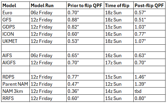
-

Jan 24-26 Weekend Snow and Sleetfest Model Thread Part Tres
caviman2201 replied to H2O's topic in Mid Atlantic
@psuhoffman re: your request from the other thread: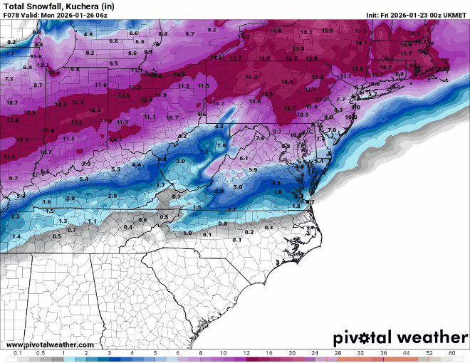
-
Seems like the 12z models shifted south a bit... or maybe a quicker transfer to the EC. Still like where we sit at this point if the energy can hang back longer.
-

January 2026 regional war/obs/disco thread
ineedsnow replied to Baroclinic Zone's topic in New England
CMC was close to something fun Thursday -

Jan 24-26 Weekend Snow and Sleetfest Model Thread Part Tres
baltosquid replied to H2O's topic in Mid Atlantic
Yeah it is more of a gentle slide or evolution towards other modeling but it's bidirectional. I am a bit more optimistic today than I was yesterday, for sure. Still think the GFS is gonna deteriorate a bit though. -

Jan 24-26 Weekend Snow and Sleetfest Model Thread Part Tres
psuhoffman replied to H2O's topic in Mid Atlantic
It has trended warmer...and some of the warmer guidance like the GGEM has trended colder...they are meeting in the middle...for us right on the line where exactly that middle is means a lot -
GFS is consistent with another storm signal in a week. One run warm nosed - apparently always a possibility. The rest are all snow. Euro will find it again. Random cold air thoughts. Being from the Plains we ALWAYS locked in shallow cold harder than models. I tried that a few times in East Tenn. Learned real quick I'm not in Kansas anymore. Warm nose wins in the Great Valley. Then east of the Apps right back to cold wins, bigly CAD right up there with Denver. Amazing.
-

2025-2026 Fall/Winter Mountain Thread
franklin NCwx replied to Buckethead's topic in Southeastern States
Seems to be doing better with this system so far. Its over a week out so I doubt it has the details correct -

January 25-26 Winter Storm Potential
Mikeymac5306 replied to Ralph Wiggum's topic in Philadelphia Region
Did I just see this come south a tick or two? Please elaborate -

Possible Record Breaking Cold + Snow Sunday 1/25 - Tuesday 1/27
SnowGoose69 replied to TriPol's topic in New York City Metro
We need to see what the 3km NAM does as we get closer in but the 12km at 12Z fits my idea that the sleet line makes it to the S shore of LI or just south and then collapses. -
Jan 24-26 Weekend Snow and Sleetfest Model Thread Part Tres
psuhoffman replied to H2O's topic in Mid Atlantic
@caviman2201 thanks for the UK map...any way you could post the one through the end of the storm...I think north of 70 gets more snow after 18z based on the thermal and precip maps. Thanks -
Jan 24-26 Weekend Snow and Sleetfest Model Thread Part Tres
JenkinsJinkies replied to H2O's topic in Mid Atlantic
12z and GFS still hasn't really caved, not what I was expecting. -

Richmond Metro/Hampton Roads Area Discussion
overcautionisbad replied to RIC Airport's topic in Mid Atlantic
It will shift by then and we'll get barely anything -

January 2026 regional war/obs/disco thread
40/70 Benchmark replied to Baroclinic Zone's topic in New England
Any storm dropping snowfall that far south will not be high end for us, unless it's a 1/100 year full phaser. -

January 2026 Medium/Long Range Discussion
NorthArlington101 replied to snowfan's topic in Mid Atlantic
It pops up randomly on guidance but CMC had it today -
E PA/NJ/DE Winter 2025-26 Obs/Discussion
Mikeymac5306 replied to LVblizzard's topic in Philadelphia Region
He's up for round 2...
-
January 2026 regional war/obs/disco thread
ineedsnow replied to Baroclinic Zone's topic in New England
Let's get it on the 2nd and make my 40th bday epic -

“Cory’s in LA! Let’s MECS!” Jan. 24-26 Disco
Damage In Tolland replied to TheSnowman's topic in New England
I’d sag that blue boob right down into NE CT -
-
I'm wary of the NAM dryness in GA since it did this last year on 1/10 too...that said that was not the same setup, this is more of a case where I can somewhat buy the idea though the RGEM not showing it is a major concern and the 3km NAM seemingly bringing the wedge back to almost CTJ or the Bama border is a concern. I think in the end the risk of the metro seeing ice storm warning criteria is higher than some think while places like GVL E-NE may see more sleet.
-

2025-2026 Fall/Winter Mountain Thread
Maggie Valley Steve replied to Buckethead's topic in Southeastern States
Yes -
No slop with this one-powdery snow with some sleet on top
-
New thread