All Activity
- Past hour
-

Appreciating Each Other/Poster Compliments
Maestrobjwa replied to SnowenOutThere's topic in Mid Atlantic
And you sir I appreciate for your love of music AND weather! There aren't many here among the regular posters that are artsy and appreciate that kind of brain That and you seem like a genuinely fun dude and brighten things here--and somebody I'd probably vibe with over a coffee or a (non-alcoholic for me) drink! -

Another Coating of Snow Saturday - "It's all we Got"
Kitz Craver replied to Sey-Mour Snow's topic in New England
This will be congrats Freak before you know it! -

First Legit Storm Potential of the Season Upon Us
HoarfrostHubb replied to 40/70 Benchmark's topic in New England
"Raise a glass" -

Central PA Winter 25/26 Discussion and Obs
AccuChris replied to MAG5035's topic in Upstate New York/Pennsylvania
Latest long range HRRR for tonight/tomorrow . -

Another Coating of Snow Saturday - "It's all we Got"
ineedsnow replied to Sey-Mour Snow's topic in New England
No pill needed -
No thread until Euro bites. Euro never once folded to the nonsense of the GFS. If anyone feels like a rug pull it’s bc they were discounting the euro all along, a path to failure more times than not. That being said, for a day everything trended west it was assumed euro would keep doing the same but it put its foot in the ground and has barely budged since. I think having a lot of Mets hyping this up and assuming it would go west got more people than normal excited too.
-
Another Coating of Snow Saturday - "It's all we Got"
HoarfrostHubb replied to Sey-Mour Snow's topic in New England
Not in the N ORH hills... a bit west maybe -

First Legit Storm Potential of the Season Upon Us
ORH_wxman replied to 40/70 Benchmark's topic in New England
This is a pretty good theory. I wonder if the bias-correction also showed up (mostly successfully imho) in the “cutter” last weekend. A lot of OP models several days out kept showing big warm sectoring into New England but the AI models kept saying no dice and it would be much colder with wedging at the sfc. Much like what happens very frequently in the past where models get too warm-sector happy east of the Apps and north of about 41N. They turned out more correct. I think they were a touch too cold but closer to reality than the original OP runs…however, the biggest difference this time around is the OPs are still pretty far apart from AI. By the time we got inside 48h last weekend, the OP and AI guidance were mostly converged. -

Let’s talk winter!! Ohio and surrounding states!! 24'-25'
dilly84 replied to buckeye's topic in Lakes/Ohio Valley
Another year, another dud for us in Central Ohio so far. I think our best shot is gonna come around mid-february otherwise- maybe a couple 2-3 inchers if we're lucky. Frankly, I'm sick of it. -
It looks like it comes is 2 waves, with the front buckling north and then back south. Most of the predawn stuff should be snow. If precip. shuts off - and esp if the sun comes out briefly, surface temperatures are likely to spike. Whoever get into the banding the longest could get some decent snow.
-
Yep, that was where we looked at back in the great Winter's of our Youth. If it was the " Ice box" we were confident as usually that air from that area made a direct shot our way.
-

Winter 25/26 General Obs
Holston_River_Rambler replied to Holston_River_Rambler's topic in Tennessee Valley
Strange, spectral (something related to lenticular?) clouds over Morgan and Roane counties: Apparently the mother ship was about to land on LeConte around noon: -
I mentioned the AI models the other for the setup end of weekend and that still absolutely holds. The fact they haven’t wavered and are even upticking (albeit slightly) should be a tell on the setup likely having some legs here. There will be a sharp western gradient most likely as best ascent will focused in corridor within the RER of the jet situated off the Atlantic coast. Best chance for “appreciable” snow will likely lie east of I-95, and more likely eastern shore to the coast. I don’t see more than 3-4” in any given location at the max, but widespread 1-3” in the impacted areas is certainly plausible in this scenario. I like areas just west of the coast for this one. Salisbury to Lewes area might be a good spot, but we’ll see as we get the CAMs involved by tomorrow and definitely by Sunday AM.
-

Pittsburgh/Western PA WINTER ‘25/‘26
TheClimateChanger replied to Burghblizz's topic in Upstate New York/Pennsylvania
Heavier "squall-like" snow showers possible tomorrow on top of the light snowfall tonight. -
Life moves pretty fast. -Ferris Bueller Rain Snow
-

Another Coating of Snow Saturday - "It's all we Got"
ma blizzard replied to Sey-Mour Snow's topic in New England
all you can do is laugh as we are getting surgically shafted going on 4 years now .. -

First Legit Storm Potential of the Season Upon Us
ariof replied to 40/70 Benchmark's topic in New England
I believe this is called the Theory of DGEX -

First Legit Storm Potential of the Season Upon Us
Typhoon Tip replied to 40/70 Benchmark's topic in New England
wait, what did i do ? wait first of all, we don't know precisely how ... and by defacto 'what' these AI (apparent marketing gimmicks ) are doing. so how can we be sure about 20 or 30 years ago anyway? that's I pointed this out yesterday.. there's been no prospecti made easy to find - if at all - that answers the questions that everybody should be asking but no one is! jesus... degradation of virtuosity and method on both side. whereby any kind of advantages and disadvantages, circumstantially; basic modeling 101 stuff that has to be considered. confidence intervals... methodologies. nothing. we can't say jack shit about them. I'm hugely displeased at deployment and anyone that uses them .... man, caveat emptor -

First Legit Storm Potential of the Season Upon Us
weatherwiz replied to 40/70 Benchmark's topic in New England
Just busting. I'm with you, it is very fascinating to see why the two camps are drastically different. My opinion on AI model aside (since ultimately my opinion means nothing), this is a tremendous opportunity within the field of forecast modeling and obviously the only way to ever see the true value in AI and how helpful will be is by putting it to the test. If the AI score a coop here that would not only be a tremendous win in the AI department but it probably also further exposes significant weaknesses in the traditional modelling. On the other hand, if the AIs fail here, then at least to me, signifies the importance of physics and complex equations and that there is much more to the evolution of weather than just on how a 'similar match' evolved historically. -

First Legit Storm Potential of the Season Upon Us
rcostell replied to 40/70 Benchmark's topic in New England
I recall the abject bewilderment. -

Another Coating of Snow Saturday - "It's all we Got"
Damage In Tolland replied to Sey-Mour Snow's topic in New England
That was supposed to be ours up to ORH county . That ocean stolen F’d it all up . -
@psuhoffman @mitchnick Let’s roll 18z Hrrr

-

Another Coating of Snow Saturday - "It's all we Got"
dendrite replied to Sey-Mour Snow's topic in New England
He may need a blue pill -

Storm potential January 17th-18th
binbisso replied to WeatherGeek2025's topic in New York City Metro
Hrrr juiced for tomorrow. Could be warning level snows for western nj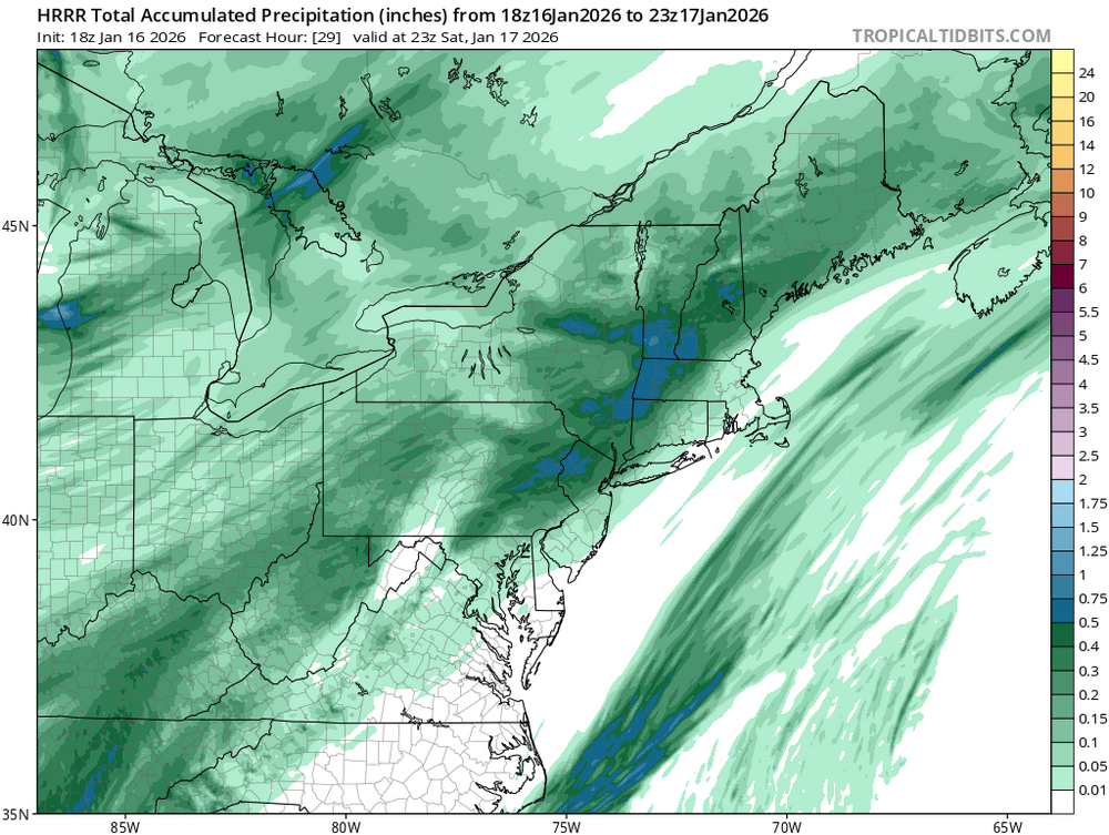
-
Cold powder.


