All Activity
- Past hour
-
Stubborn coach, a good GM who royally screwed up, smh
-
RRFS for the win out here!
-

Mid to long range discussion- 2025
WinstonSalemArlington replied to wncsnow's topic in Southeastern States
Larry Cosgrove: “ With many model forecasts and human projections of a major warm-up across the lower 48 states for the holiday period, those like me who want a big cold wave or heavy snow and ice event have to wait out at least 6 days of some cases of record warmth before an Arctic intrusion returns to the lower 48 states. The question is, could the warmth last further? If you based odds on the model guidance alone, the odds on a cAk placement below the Canadian border are about 3 in 7. The American and European series are closest to the analog support, but the GEFS and ECMWF versions have members that show a return to a broad +PNA/-AO/-NAO signature that would return the eastern half of the continent to an extremely cold scenario with chances for snow in the Great Lakes and the Eastern Seaboard. Cautions I apply to the forecast: do NOT make assumptions based on the Madden-Julian Oscillation predictions (see what I mean about all of that "Phase 8" nonsense that was the talk of the internet?). Remind yourself that for an MJO cold influence in North America, the lead impulse should be between Phases 6 and 1, be very strong, and have at least some connection to the polar westerlies. The numerical model Wheeler diagrams are not useful in this regard. Also, for a Sudden Stratospheric Warming alteration in sensible weather, consider that the 10MB warm anomaly should be on the American side of the North Pole, should foreshadow a high-latitude blocking signature and will occur 2 to 4 weeks following the SSW. You would want to see either some splitting or persistent positioning of the warming pool. Using previous stratospheric warming projections, I suspect that the lower 48 states are going to feel another cold wave in the Christmas/New Year hammock week, and maybe 5 to 7 days beyond. On the idea that we see a climatologically-favored "January Thaw, the middle of next month could be as warm as what we are looking at by this weekend. But I concur with the analog set that the latter third of the first month of the new year will turn quite cold, perhaps lasting through February with better potential for ice, snow further south and east than before. Clues to look at: the expanded snow and ice cover, similarities to 2007 and 2024-25. Around Christmas or shortly thereafter, winter should fight its way back into the U.S.” -
12/14: 3.3” Total: 4.1”
-

December 14th - Snow showers or Plowable snow?
Torch Tiger replied to Sey-Mour Snow's topic in New England
Around 1", about as expected -

December 14th - Snow showers or Plowable snow?
40/70 Benchmark replied to Sey-Mour Snow's topic in New England
Yea, we were on the same page. Glad it worked out..withstood the model waffles, when it looked meager on Friday, then beefed up last night...stayed the course. -
The Ravens are already yellowing my snow. This offense is so fucking bad, mostly because of a terrible OL.
-
I'd have to say this event over performed for most.
-
-

December 14th - Snow showers or Plowable snow?
SouthCoastMA replied to Sey-Mour Snow's topic in New England
3.25 as of 1p might be tough getting to 6" but wildcard is the inv trough tonight -

December 2025 Short/Medium Range Forecast Thread
Matthew70 replied to John1122's topic in Tennessee Valley
MJO for the win Carver you’ve been all over this. Gawx has also. -
So, your high end of 25” is near my new low end as I’m essentially 25”+ for the entire season based on today’s storm. Are you going to raise your prediction from your 15-25” range?
-
no, i have to tolerate the opposite.....ever sit on a rocking boat when its clear you should be heading in but the captain swears its going to calm down?
-
5.75" total so far. It's brutal out there!
-
JB says the MJO is correcting back to phase 8 and the NAO is going negative again and that the models are correcting to a colder look for the period leading up to Christmas.
-
I'm seeing at least 3 or 4 days over the next 10 days where we may be in the 70s ! This is crazy for Mid to Late December.
-
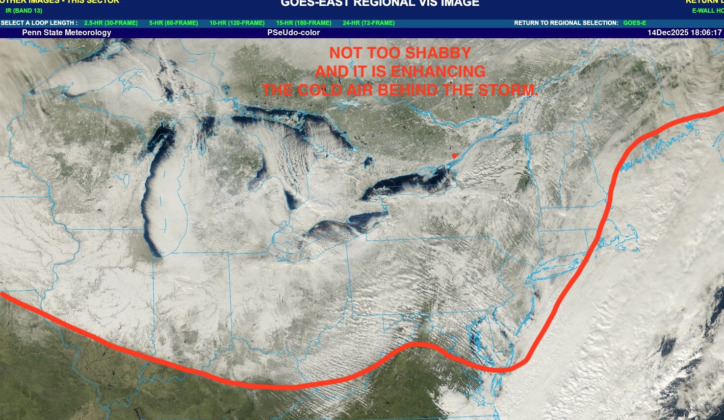
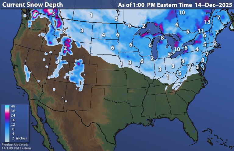
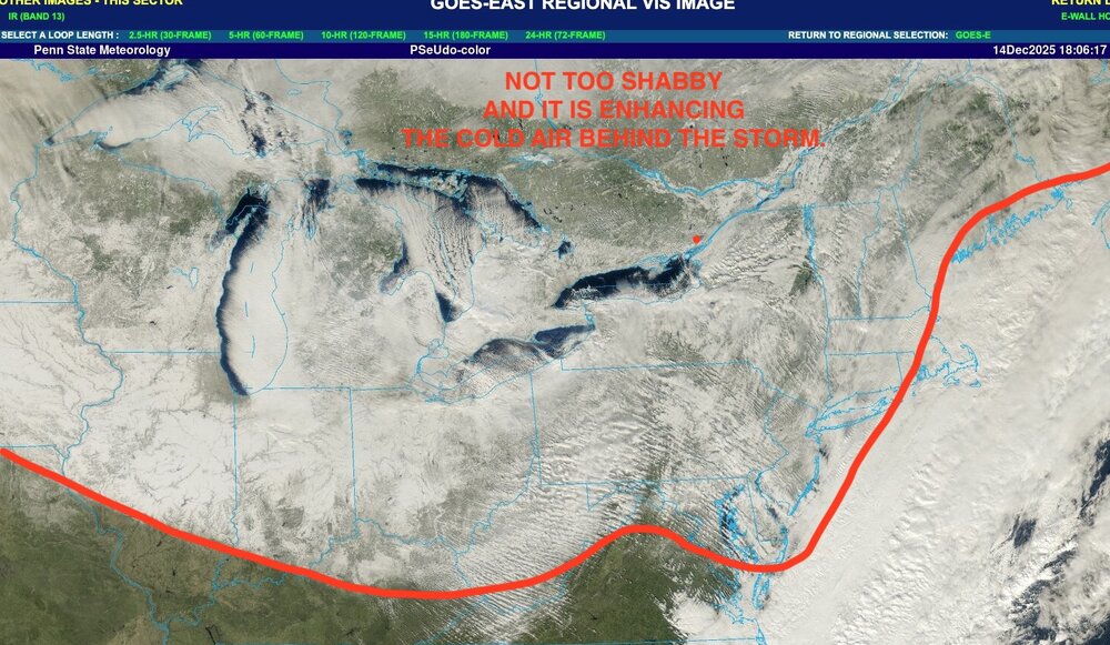
Wider view of snow cover.
-

December 2025 regional war/obs/disco thread
WinterWolf replied to Torch Tiger's topic in New England
As we said…Ops Will waffle. -
Decent miller b pattern in the long range
-

2025-2026 ENSO
donsutherland1 replied to 40/70 Benchmark's topic in Weather Forecasting and Discussion
My thinking for seasonal snowfall for Central Park was 15"-25". It will be interesting to see how things evolve. -

December 14th - Snow showers or Plowable snow?
HoarfrostHubb replied to Sey-Mour Snow's topic in New England
Nice to see flakes flying at the Pats game -

December 14th - Snow showers or Plowable snow?
FlashFreeze replied to Sey-Mour Snow's topic in New England
Light snow has ended and wind is picking up, 0.75” of fluff, 23° -
70s is not considered a torch ?
-

Central PA Winter 25/26 Discussion and Obs
canderson replied to MAG5035's topic in Upstate New York/Pennsylvania
Did you get anything? I know Lemoyne essentially had zilch like us. -