All Activity
- Past hour
-
Consider them the outlier right now. Probably a bit too cold. Mid-teens in the afternoon is a better bet.
-

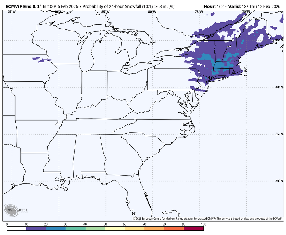
Friday February 6 FROPA / WINDEX small event
Kitz Craver replied to HoarfrostHubb's topic in New England
Central CT subsidence west of the IVT -
I agree it will end up being a cold and possibly snowy month overall, but I do agree with the idea of a mid month relaxation period.
-
GSP really should extended advisory down further so this doesn't catch people off guard. The ground is prime for this to be a mess on the roads and temps keep trending downwards.
-

Friday February 6 FROPA / WINDEX small event
TauntonBlizzard2013 replied to HoarfrostHubb's topic in New England
Agreed. I think many who don’t end up in the Norlun are going to be disappointed. And good look pinning down exactly where it will set up. -
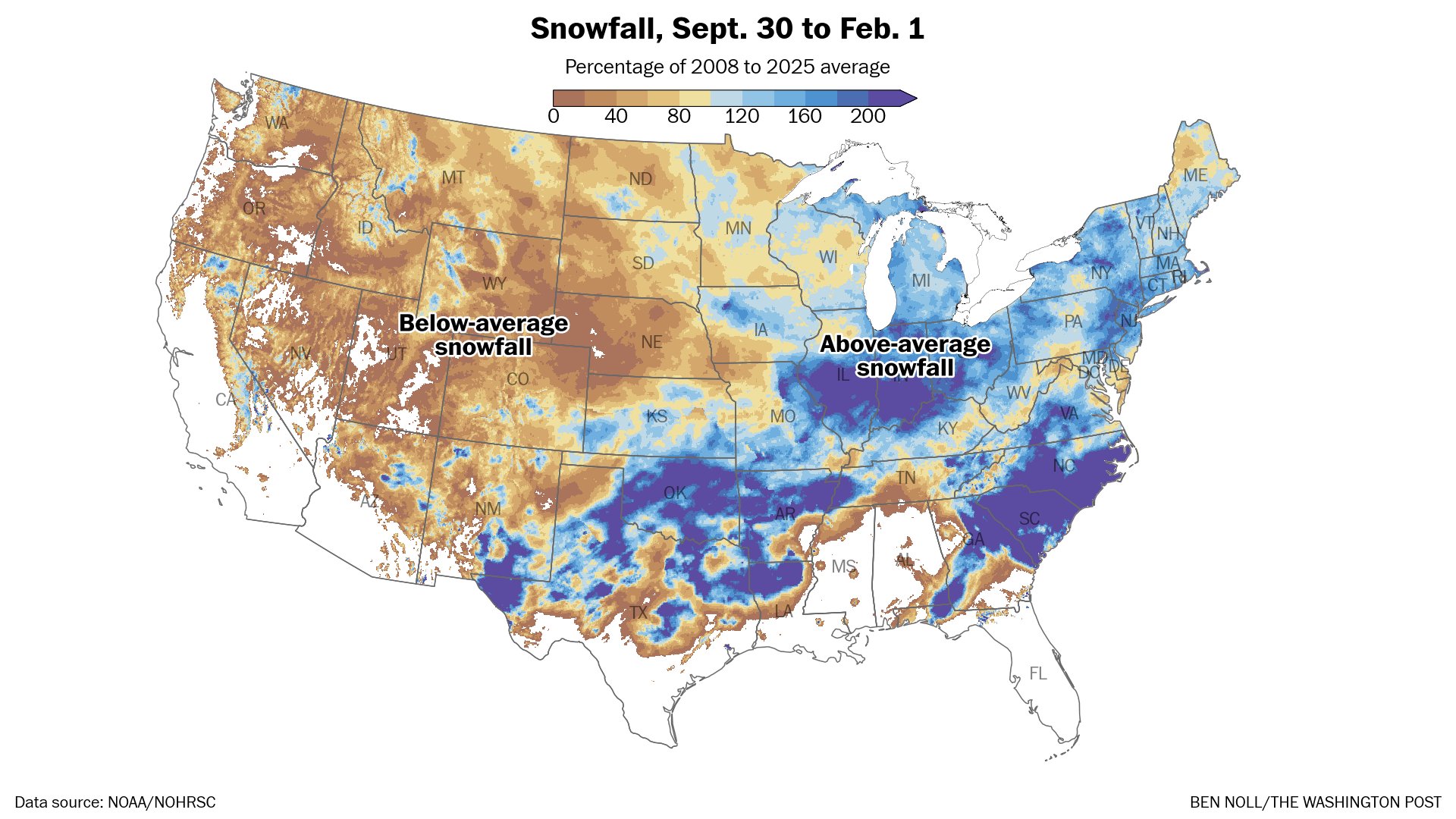
While there is certainly time left, many of us missed a golden opportunity to have a banger of a season. Places in all direction are well above normal.

-

Friday February 6 FROPA / WINDEX small event
dendrite replied to HoarfrostHubb's topic in New England
Yeah I think that’s been modeled for awhile. It’s feeling the tug from that H5 low. We get a little meso high over PWM to start and then a lobe from that PV starts digging S of LI and seems to really help back the flow over ENE as we get sfc pressure falls near the BM. I think that’s why we’ve seen a trend on that fropa being delayed Saturday and instead enhanced precip along that slowing sfc convergence zone (inv trough).
-
Get a pair of these snow goggles:
-
 JB created it in a lab. Frankenhecs
 -
Not overlooked by me. Totally agree with you. I find people just don’t want to hear about it or pay attention to it at this time of year. We need to get into an above normal precipitation pattern soon or there will be significant issues as we head into the warm season. We have been in a prolonged below normal precipitation pattern for the better part of a year.
-
Potential for 1-3/2-4 is there I think. Looks like a narrow stripe of snow, with a whiff on the north side possible, and rain on the southern side.. If we get some redevelopment off the coast then we'd have a chance at higher totals around warning snowfall..
-
-SN in Cambridge/Boston out the window (office in Kendall Sq).
-

February 2026 Medium/ Long Range Discussion: 150K Salary Needed to Post
Ji replied to Weather Will's topic in Mid Atlantic
someone gave JB access to the google model making feature -
Sunny here in Weaverville.
-
Agree
-
How good are HRRR surface temps? It barely has DC getting above 10 tomorrow.
-
Then we have our 5 day thaw potential..

-

Is we back? February discussion thread
Damage In Tolland replied to mahk_webstah's topic in New England
https://x.com/raleighwx/status/2019772590475129058?s=46&t=dhcbvkjmRcyBVQtDxJ3lRg -
I doubt it with the PNA going negative. The STJ should wake up.
-

Pittsburgh/Western PA WINTER ‘25/‘26
TheClimateChanger replied to Burghblizz's topic in Upstate New York/Pennsylvania
Surprised to see some areas of freezing drizzle on my way into work today. -

February 2026 Medium/ Long Range Discussion: 150K Salary Needed to Post
CAPE replied to Weather Will's topic in Mid Atlantic
Unlike yesterday, that wasn't really directed at anyone, just a general statement. I was actually replying to my own post lol. -

Friday February 6 FROPA / WINDEX small event
CoastalWx replied to HoarfrostHubb's topic in New England
12z models look good. Congrats cstl Essex county I think. -

Friday February 6 FROPA / WINDEX small event
George001 replied to HoarfrostHubb's topic in New England
Yeah this looks like more of a norlun event than a widespread plowable snow. I’m not expecting much from this, someone could end up with a surprise but I would think it’s a small area. -

Winter 2025-26 Medium/Long Range Discussion
Stevo6899 replied to michsnowfreak's topic in Lakes/Ohio Valley
That's what's great about this forum. When we're in boring stretches, this helps entertain. Only thing missing is a 8+ event. -
 Also seeing that latest guidance keeps areas like binghamton, Albany and Syracuse NY sub zero all day Saturday… Good luck infrastructure….