All Activity
- Past hour
-

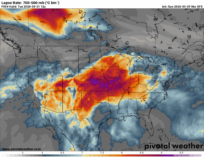
2026-2027 El Nino
40/70 Benchmark replied to Stormchaserchuck1's topic in Weather Forecasting and Discussion
Absolutely, and we will be until the turn of the decade, but there are ENSO driven deviations from the multidecadal cycle....look at 1957....also near solar max and preceded by consecutive -PDO +ENSO events. -

E PA/NJ/DE Spring 2026 Obs/Discussion
PhiEaglesfan712 replied to PhiEaglesfan712's topic in Philadelphia Region
The snow season is officially over: https://x.com/epawawx/status/2038305484810092870 -
Very cool this weekend after 85 on Thursday and Friday. That cold blast last week screwed up my plants. My day lilies have yellowed leaves, azaleas black leaves, and dead buds. Also my gardenias buds are black. This up and down weather has ruined my spring plants.
-
Loop of the March 14th-16th blizzard and severe weather system https://great-lakes-salsite.web.app/Mar_14_2026_GFS_surface_loop.html
-

It's time to grade Winter 2025-26(now that it's actually over)
Bob Chill replied to CAPE's topic in Mid Atlantic
Easy A- grade here Climo is lower in my hood but over 14" is climo+ and having a 2 week period of complete snowcrete cover is quite rare. Accum snow in each month DJFM + plenty of cold temps made it a door to door winter appeal. Again, pretty rare. Had snow on snow during the snowcrete stretch and that's always a nice bonus in any winter. Only reason I can't go A is I couldn't manage a 4"+ single storm. There's plenty of history down this way with bigger storms in the 6-18" range. Just missed that on the Carolina big storm as areas just 30 miles to my south picked up 6" or more. Had that event produced (I got 2.5"), it would have been an easy A grade. A+ (imho) requires a double digit snow even along with all the other important factors -
30 here…thinking that may be the last sub freezing reading of the season. What do yall think?
-
From this mornings 20's to some 80's 3 days later NWS Wednesday temps:
-
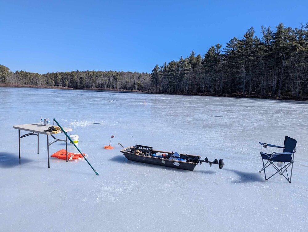
Right near shore it was actually over 10". The thinnest I went to was 4", as that's minimum safe thickness. The cold temps the last two nights actually really hardened and locked it up pretty good The PFD is for when I go test the thickness lol. This place is only like 6 ft deep as well.
- Today
-
 Great example of UHI from this morning. Approximately 80 miles apart and similar coastal locations, elevations and latitude. KCPK 34 KFOK 13 Not to derail a great discussion. I have been following you’re great analysis of the SW climate change induced warming over the years. .
 -
We never put it away. Paid the price bigly of course
-
 Yeah, the UHI is real but it seems clear this event has been incredibly anomalous even outside of the big cities. One example is that Nogales has seen 11 record highs in a row. Nogales is a fairly small town whose population today (just under 20,000) is barely higher than it was in 1980. Looking at satellite views, you can tell there is not much paved area there (even the cross-border Nogales is quite compact) and it’s surrounded by undeveloped mountains, so it seems like a good foil to Phoenix.
 -
The dry air did work overnight, it got down to 23 this morning. My forecast low was 34.
-

E PA/NJ/DE Spring 2026 Obs/Discussion
Birds~69 replied to PhiEaglesfan712's topic in Philadelphia Region
25F in North Wales around 7:00 a.m. this morning. Not sure if that was low or not. In Lansdale, ice cream truck is roaming around 12:50pm/51F and a breeze, no joke. Must be hard up for cash? I was tempted to approach him and ask why he doesn't serve beer instead? Especially on the weekend...really can't see ice cream sales booming today. -
How thick is the ice? One thing I liked about spring fishing you didn't have to dig through 2 feet of ice.
-

2026-2027 El Nino
Stormchaserchuck1 replied to Stormchaserchuck1's topic in Weather Forecasting and Discussion
Very positive +NAO this March 33 of the last 46 March's have been +NAO (78%) It has been an anchor month for the decadal state. Jan, Feb, Dec have all been positive in the last 46 years too. Europe's skew of snowless Winters, and especially Germany, has been a little altered by the decadal NAO progression. -
Tremendously dumb. Lol at the PFD on the ice.
-
Man you’re nuts
-

It's time to grade Winter 2025-26(now that it's actually over)
Weather Will replied to CAPE's topic in Mid Atlantic
Temps: A: reminded me of a 1970s winter. Sustained cold kept the snow we had on the ground for a record breaking amount of time. Snow: B+: only about 16 inches total but since it stayed on the ground a long time I bumped it up. Overall grade: A-. -
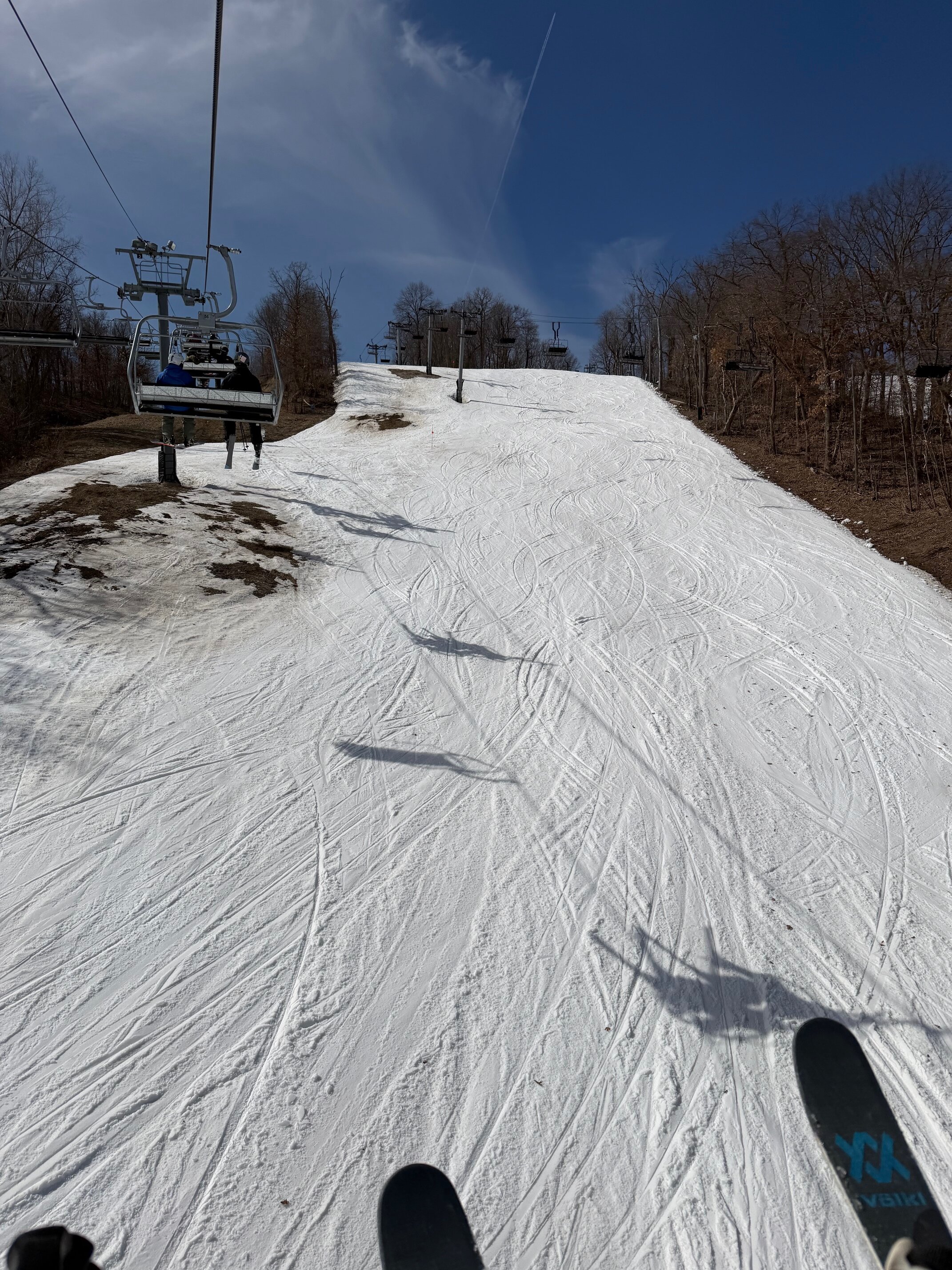
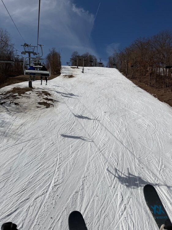
Annual pond skip yesterday at the ski hill for closing day. Always a good time. Sun came out and warmed us to the low 50s for a fantastic final day on the slopes for winter 25/26. I got 24 days on the snow this winter. Lutsen is open through at least May 3rd so I still have options to get on the snow one more time since everything out west is toast.
-
And up to 45 now. Soon as the sun comes up that cold goes poof.
-

Chester County PA - Analytical Battle of Actual vs. Altered Climate Data
Cobalt replied to ChescoWx's topic in Climate Change
You have to be playing a persona, right? Because you can't just go on to say this and then go on to IMMEDIATELY post this it is beyond parody. -
Still ice here in N ORH if you know where to find it! Definitely the last day though.
-
-
2026-2027 El Nino
Stormchaserchuck1 replied to Stormchaserchuck1's topic in Weather Forecasting and Discussion
The SW heat ridge/drought started in 1995, and 1998 is when the -PDO began.. that SW pattern is amped max right now. I personally think we are still in -PDO general and the Southwest pattern also goes with +AMO. Solar Max may have changed things a bit though. I've looked at what 2 cold NE Winter's in a row means for year 3.. it's neutral, 50/50. -
(002).thumb.png.6e3d9d46bca5fe41aab7a74871dd8af8.png) bdgwx just keep on cherry picking - you will always get the anwer you want!!
bdgwx just keep on cherry picking - you will always get the anwer you want!!