All Activity
- Past hour
-

WxUSAF's weak ass frontal passage thing.
Solution Man replied to dailylurker's topic in Mid Atlantic
Keep an eye on the milk and bread lines. -
I wish this was true
-
Hi in the mid teens. Beautiful scene today at Swallow Falls (Garrett County MD)
-
I don't know about other counties, but Fairfax is still a mess from the "snowcrete". We have one lane roads in neighborhoods everywhere, and may of the buses are still sitting in snowy parking lots. I honestly can't imagine how schools will go back tomorrow. Another 1-2" on freezing roads will close us on Wednesday. What are other counties like?
-
Holy smokes, you’re not far behind TBlizz and Scott. Where did you hear that? I don’t think we know since it hasn’t happened yet lol.
-
Setting the DCA line at 0.1", I'm hammering the over
-
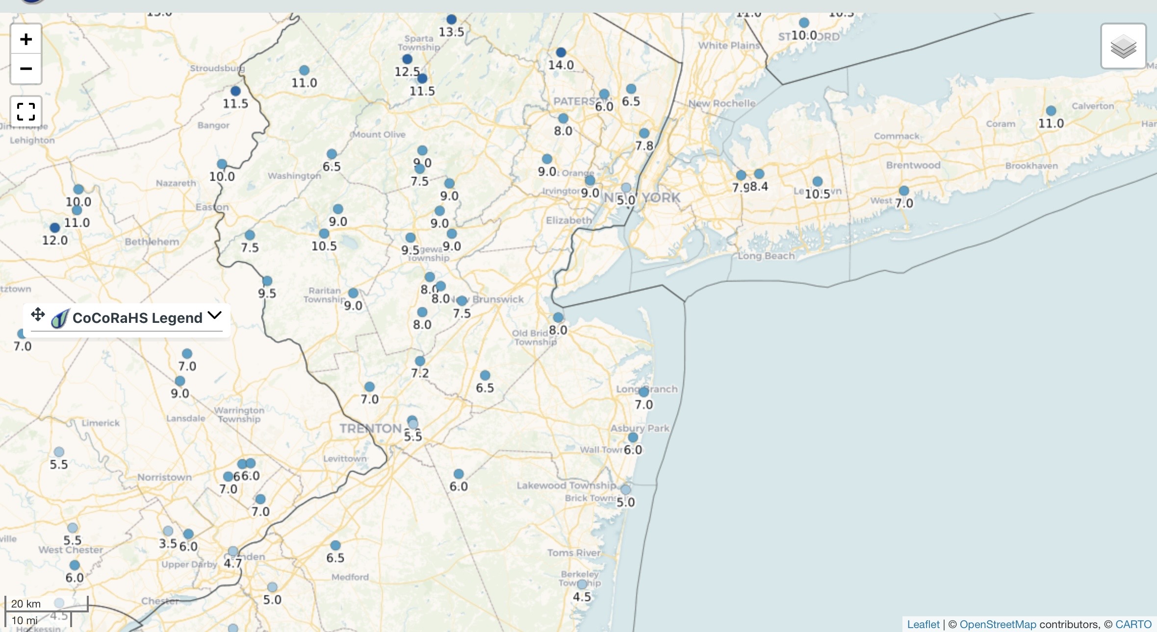
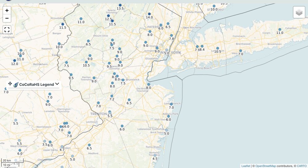
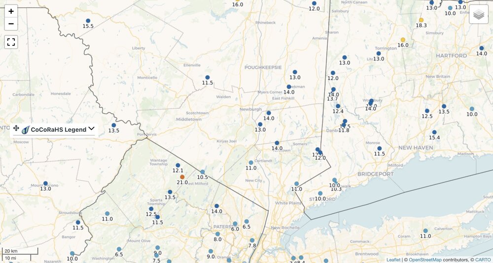
This morning’s snow depth
-

WxUSAF's weak ass frontal passage thing.
nw baltimore wx replied to dailylurker's topic in Mid Atlantic

-
1.4” of snow at MSP today. 29.3” season to date.
-
Dry Tortugas not so dry today.
-

E PA/NJ/DE Winter 2025-26 Obs/Discussion
Lady Di replied to LVblizzard's topic in Philadelphia Region
Sunny and 24F feels like 2. Wind chimes are singing and seeing a bit of blowing snow. Hawk sighting earlier on my deck.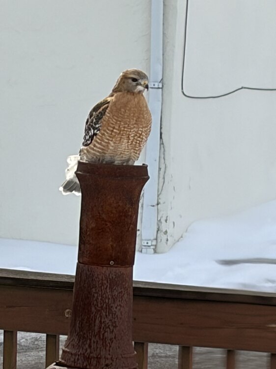
-

February 2026 Medium/ Long Range Discussion: Buckle Up!
snowmagnet replied to Weather Will's topic in Mid Atlantic
We had around 10 inches last year in the first week of January. And a really nice storm in 2022. I think that one was Jan. 3rd. -

WxUSAF's weak ass frontal passage thing.
midatlanticweather replied to dailylurker's topic in Mid Atlantic
Flizzard advisories and snow fairies as my kids used to say. Any snow is a win -
January 30th- Feb 1st ULL and coastal storm obs
GunBlade replied to JoshM's topic in Southeastern States
And the dry slot Brad P was concerned about and so many gave him crap for played out pretty accurately. Obviously totals were basically higher everywhere than forecasted but still the gap between the ULL and coastal low played out. -
I've got a good feeling about this storm.
-
The wind blew a lot of it away last nigjt here. It will be gone by tomorrow. Its already gone in sunny areas. Extremely low moisture content
-
What time is this to occur?
-
Guessing the SSWE will not effect us.
-
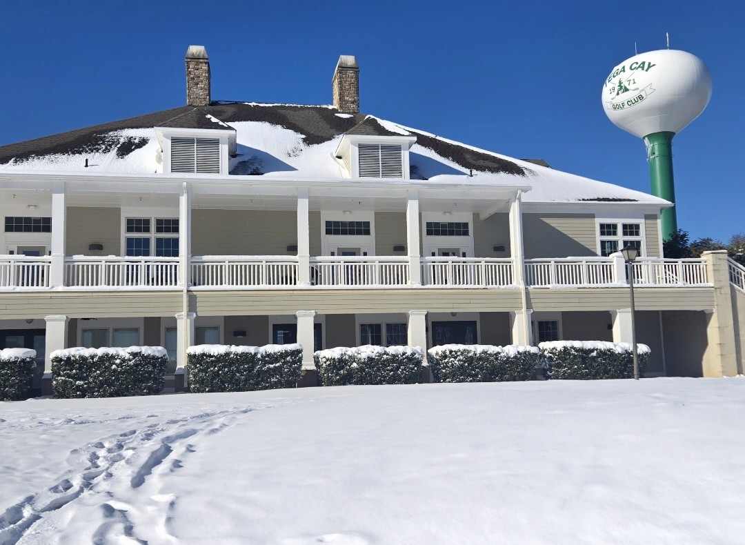
Place gives me kind of a weird Overlook Hotel vibe, especially in the snow lol

-
3 clipper monte Wed (2/4) : Perhaps a dusting Sat (2/7): Perhaps a coating Mon - Tue (2/9-10) GGEM snow
-
The wheel has spoken. Haha
-
Canadian looked similar, but it did have a 1.2" bullseye for SBY
-
12z model guidance 10:1 accumulation. We've got a borderline case in SWVA. With snowcover out to the plateau low level westerly advection is going to pay an extra tax tuesday afternoon on top of local reflectivity. What soundings I checked show a relatively blunt 700mb to surface zone of mid thirties in the near miss cases. This one is probably lost between 700 and 850 since I struggle to believe it gets above the upper 30s close to the surface.
-
JFK Jan: -3 (29.9) / 2.47 LE / 13 snow
-


.thumb.JPG.418e8a9a2902ae687ec35ff4bc0e038e.JPG)