All Activity
- Past hour
-
Loved seeing the small flakes on/off yesterday as I did some shopping. Low of 27 at 6:44am. Hoping for 60 today.
-

December 14th - Snow showers or Plowable snow?
Ginx snewx replied to Sey-Mour Snow's topic in New England
Trending slower further Northwest. Nice -

Central PA Winter 25/26 Discussion and Obs
GrandmasterB replied to MAG5035's topic in Upstate New York/Pennsylvania
Seems like it’s been a little while since we had an event trending better and better right up until go time. Ya love to see it! -
I enjoy all the snow I receive. Even 1 cm is appealing. Nevertheless, when posting statistics, even the ugly data (streak in my post) will be mentioned periodically for purposes of completeness.
-

12/14: Sunday funday? Will the south win again?
BlizzardNole replied to TSSN+'s topic in Mid Atlantic
I tried to find a pic of my late 70s Bearcat weather radio - it was off white with an orange on/off button. That's all I had, along with local news and 936-1212 LOL I'm getting more hopeful for the snow with latest models. Let's keep the good trends going and fill that gap in the western part of our forum! -
I saw one of these gradient type events two years ago with the I78 death band. Four miles separated 6” amounts from 10” amounts. You cannot underestimate these gradient events.
-

12/14: Sunday funday? Will the south win again?
MN Transplant replied to TSSN+'s topic in Mid Atlantic
RRFS is a dud for Virginia but looks good north of Baltimore. -

12/14: Sunday funday? Will the south win again?
dailylurker replied to TSSN+'s topic in Mid Atlantic
I remember calling the weather line. My parents would get pissed because it wasn't free. I'd be calling it 10 times a day for updates lol. I had the same weather radio lol -

12/14: Sunday funday? Will the south win again?
DDweatherman replied to TSSN+'s topic in Mid Atlantic
It’s led the charge as other models moisten and reward a larger chunk of the sub. -
It's a solid run for sure.
-
I remain cautious and quite conservative anywhere along and north of the I-84 corridor; a general 1.5 to 2, with low pop of iso 3"? Cape area looks good; 3 to 5, spot 5+; and a general 2 to 3 with isolated 4's across southern CT; maxing out in New London County...
-
Rgem remains consistent with area wide 3-5”
-
Rgem mostly held serve but beefed up a bit for southern areas. Ocean County 6+
-

December 14th - Snow showers or Plowable snow?
Baroclinic Zone replied to Sey-Mour Snow's topic in New England
12z RRFS is pretty robust.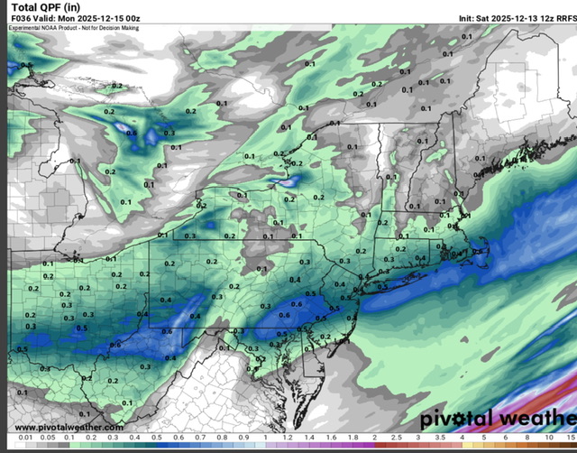
-
(002).thumb.png.6e3d9d46bca5fe41aab7a74871dd8af8.png)
Saturday night/Sunday 12/13-12/14 Jawn
ChescoWx replied to Ralph Wiggum's topic in Philadelphia Region
Some models for all - which one will be closest to reality? -

December 14th - Snow showers or Plowable snow?
ORH_wxman replied to Sey-Mour Snow's topic in New England
Looks like ICON and Reggie nudged a little north too. -
I did it as an adult! Lol
-
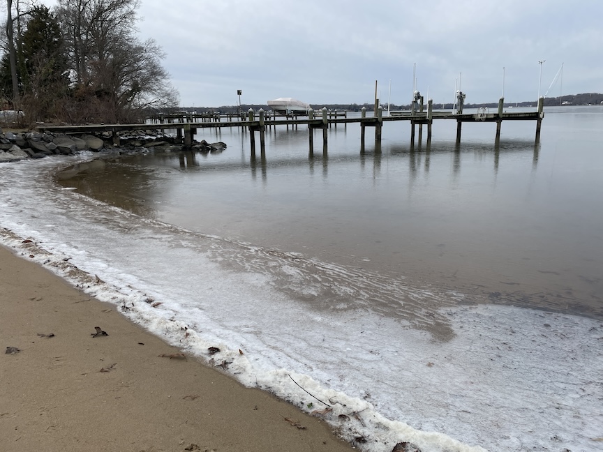
Here's some frozen water for ya. Shot from yesterday morning.
-

12/14: Sunday funday? Will the south win again?
somecallmetim replied to TSSN+'s topic in Mid Atlantic
This was me before cable. This plus reg radio, and trying to switch between the three local news stations at about 20 past 6 or 11 so I could catch channel 3, 8 and 30 weather forecasts in CT.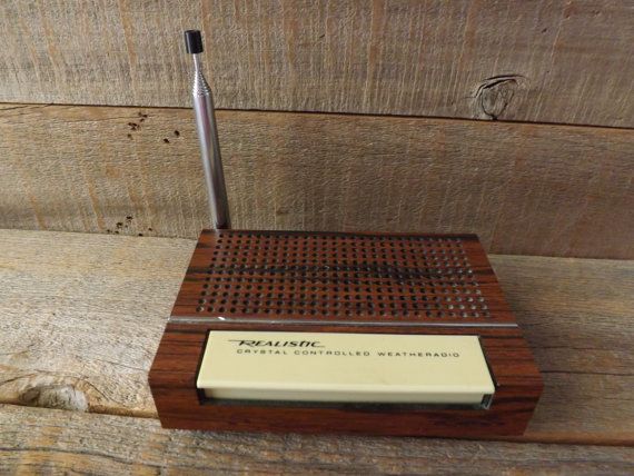
-
I'm riding the northern edge in Morristown so could see 1 or 4 inches just as easily depending how far north this goes; hoping for at least 2" to cover everything up - im not greedy
-
Records: Highs: EWR: 68 (2015) first of many record highs that month / season NYC: 67 (2015) LGA: 63 (1946) JFK: 70 (2015) Lows: EWR: 8 (1960) NYC: 8 (1960) LGA: 8 (1960) JFK: 8 (1960) Historical: 1821" Cold snap begins at Ft. Snelling, MN. The temperature was below zero for 19 days except one. (Ref. AccWeather Weather History) 1878: the temperature fell to 30 degrees in Los Angeles was the coldest ever in the month of December. (Ref. AccWeather Weather History) 1915 - A heavy snowstorm kicked off the snowiest winter in modern records for western New England. (The Weather Channel) 1932: A frigid storm hit the region beginning the previous day continuing on this day. These days were likely the coldest on record in Southern California. On this day the high temperature in Santa Ana was 45 °F, 46 °F at Palm Springs and 48 °F at Escondido, the lowest maximum temperature for those locations on record. Yuma, AZ managed an afternoon high of only 36 °F, setting their lowest high temperature for the date. (Ref. Wilson Wx. History) 1962 - A severe Florida freeze occurred. Morning lows reached 35 degrees at Miami, 18 degrees at Tampa, and 12 degrees at Jacksonville. It was the coldest December weather of the 20th century and caused millions of dollars damage to crops and foliage. In Georgia, the morning low of 9 degrees below zero at Blairsville established a state record for the month of December. (David Ludlum) (The Weather Channel) 1963: Behind a strong cold front, arctic high pressure moved down bringing record low temperatures to a few locations including: Chester, MT: -30 °F, Townsend, MT: -24 °F, Lewistown, MT: -22 °F, Stanford, MT: -22 °F, Billings, MT: -16 °F, Rapid City, SD: -10 °F. (Ref. Wilson Wx. History) 1967: (13th-20th) Today began 8 days of occasional snows for most of NM except the E. 1-4 feet fell over parts of W counties and mountains; drifts to 20 feet high in Torrance County. Winds to 87 mph northeast of Las Cruces on the 14th. (Ref. Weather Guide Calendar with Phenomenal Weather Events 2011 Accord Pub. 2010, USA) 1984: A winter storm beginning on the date through the 15th left a heavy ice coating across parts of northwest Oklahoma. One to two inches of ice accumulated on everything in the area. The weight of the ice brought down power lines, leaving about 6,000 people without electricity for a week. Ice also caused severe damage to trees, even uprooting some of them. (Ref. Wilson Wx. History) 1987 - A major winter storm produced high winds and heavy snow in the Southern Rockies and the Southern High Plains. Snowfall totals in New Mexico ranged up to 25 inches at Cedar Crest, with up to three feet of snow reported in the higher elevations. Winds of 75 mph, with gusts to 124 mph, were reported northeast of Albuquerque NM. El Paso TX was buried under 22.4 inches of snow, including a single storm record of 16.8 inches in 24 hours. The snowfall total surpassed their previous record for an entire winter season of 18.4 inches. Record cold was experienced the next three nights as readings dipped into the single numbers. High winds ushering unseasonably cold air into the southwestern U.S. gusted to 100 mph at Grapevine CA. (The National Weather Summary) (Storm Data) 1988 - Low pressure off the Atlantic coast produced up to a foot of snow in eastern Nassau County and western Suffolk County of southeastern New York State. Mild weather prevailed across the western half of the country. Nine cities reported record high temperatures for the date, including Goodland KS with a reading of 74 degrees. (The National Weather Summary) (Storm Data) 1989 - Strong northwesterly winds, ushering bitterly cold arctic air into the central U.S., produced squalls with heavy snow in the Great Lakes Region. Snowfall totals in Upper Michigan ranged up to 24 inches at Manistique. Nine cities in Arkansas and Texas reported record low temperatures for the date, including Calico Rock AR with a reading of 4 degrees above zero. (Storm Data) (The National Weather Summary) 2002 - A powerful Pacific storm system plowed into the western United States during the 13th-16th, producing high winds, heavy rains, significant mountain snowfall and causing 9 deaths (Associated Press). Rainfall amounts exceeding 10 inches occurred in parts of California, and wind gusts over 45 mph produced up to 1.9 million power outages during the period (Pacific Gas & Electric).
-

December 11th-14th Double Banger Clippers
Chambana replied to Jackstraw's topic in Lakes/Ohio Valley
Looks like a heavy band just south of Peoria -
I heard he’s been picking up frequent shipments from 2kft in SVT.
-
Completely agree and liking the latest NBM, especially for NYC/NENJ/LI - first time we've seen amounts over 4" for NYC and nearby locations from the NBM.
-
30 / 20 cloudy and we'll see if we can get to 40/low 40s. Snow overnight and through the morning into early afternoon Sunday 1 - 3 / 2 - 4 with some spots to 5. Cold Mon - Tue. Moderation to and above normal by the 18th through Christmas. Beyond there near normal with a bit back and forth and we'll see if a storm threat can materialize by and for New Years eve.


