All Activity
- Past hour
-
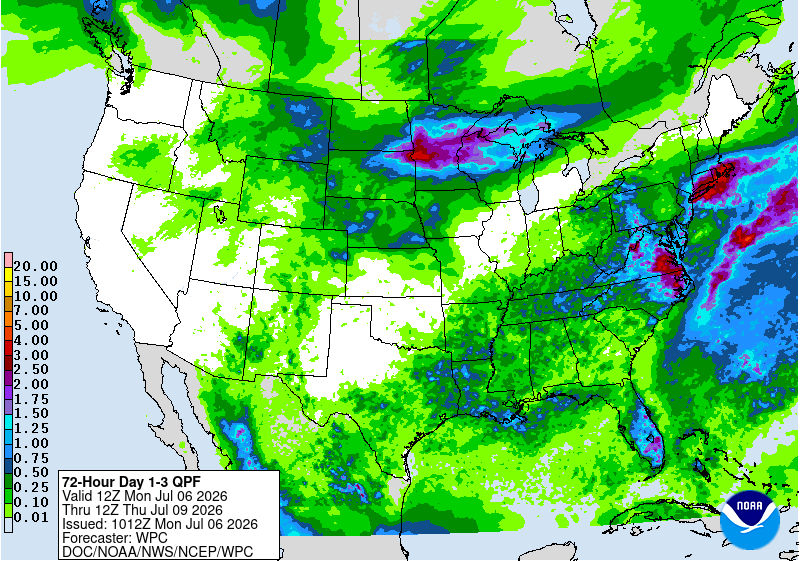
The location of the heaviest potential with HFEF max around the region usually shifts from run to run. But the signal is there mesoscale banding producing localized 5”+ amounts. Sometimes the mean chart is closer and other times the max does better. We never really know for sure. The WPC and NWS use that as one of the models for their QPF forecasts. We can see a few spots so far are over 3”. But the nature of convection usually means that the models can’t really pinpoint the exact locations. The latest runs have shifted east a bit which is par for the course with convective rainfall forecasts.
-

Big Heat (and storms?) Week into July 4th Weekend
MN Transplant replied to yoda's topic in Mid Atlantic
0.01” DCA is now -7.28” year to date -

Hoisting the Sultan Signal: Heavy Rain Event July 5-7
weatherwiz replied to WxWatcher007's topic in New England
Looking like the max totals will def be towards the coast but probably nothing obscene. Probably some totals up around 4-5"...maybe someone gets 6" -

Big Heat (and storms?) Week into July 4th Weekend
SnowtoRain replied to yoda's topic in Mid Atlantic
0.93" last night -
Picked up 0.45” late in the game.
-
.10" yesterday evening. Staunton was under a Warning for about 30 minutes. West-side received around 2.00".
-

Hoisting the Sultan Signal: Heavy Rain Event July 5-7
TauntonBlizzard2013 replied to WxWatcher007's topic in New England
Going to be in the have nots here -
@vortex95 - It sure looked like it had a bit of the "supercellular look" looking west from Odenton. Sadly didn't get any pictures - heck of a storm once it got to Odenton, though. Some shutters were torn off the condo building!
-
And underwhelming half inch the past 2 days. Still under an inch past 4 days
-

2026-2027 Super El Nino
GaWx replied to Stormchaserchuck1's topic in Weather Forecasting and Discussion
If those were for early July I’d agree. But the BoM little circles represent the average for the full months. -

2026-2027 Super El Nino
roardog replied to Stormchaserchuck1's topic in Weather Forecasting and Discussion
If I’m looking at the BOM correctly, isn’t it already too warm for early July? -
This system just kept hammering you guys up there!
-

2026-2027 Super El Nino
snowman19 replied to Stormchaserchuck1's topic in Weather Forecasting and Discussion
Unlike 2015, region 4 is actually consistently cooling. Crankywxguy pointed this out the other day. It is nowhere near as warm as 2015. This is the animation since April, with a consistent, pronounced cooling in region 4. It’s actually on the verge of dropping below weak El Niño levels to neutral/La Nada @roardog -
 That line was talking a big game. All show and no grow.
 -
Yeah definitely didn’t get the goodies, orange county and areas NW got a good drink.
-
Flood Watch National Weather Service Baltimore MD/Washington DC 409 AM EDT Mon Jul 6 2026 ...The combination of a slow moving frontal zone with a tropical air mass in place will increase the risk of flash flooding this afternoon and evening... DCZ001-MDZ003>006-008-011-013-014-016>018-503>508-VAZ027>031-037>040- 050-051-053>057-501-502-505>507-526-527-WVZ051>053-061615- /O.NEW.KLWX.FA.A.0005.260706T2000Z-260707T0400Z/ /00000.0.ER.000000T0000Z.000000T0000Z.000000T0000Z.OO/ District of Columbia-Washington-Frederick-Carroll-Northern Baltimore-Cecil-Southern Baltimore-Prince Georges-Anne Arundel- Charles-St. Marys-Calvert-Northwest Montgomery-Central and Southeast Montgomery-Northwest Howard-Central and Southeast Howard-Northwest Harford-Southeast Harford-Shenandoah-Frederick- Page-Warren-Clarke-Albemarle-Greene-Madison-Rappahannock-Orange- Culpeper-Fairfax-Arlington/Falls Church/Alexandria-Stafford- Spotsylvania-King George-Northern Fauquier-Southern Fauquier- Western Loudoun-Eastern Loudoun-Northern Virginia Blue Ridge- Northwest Prince William-Central and Southeast Prince William/Manassas/Manassas Park-Morgan-Berkeley-Jefferson- 409 AM EDT Mon Jul 6 2026 ...FLOOD WATCH IN EFFECT FROM 4 PM EDT THIS AFTERNOON THROUGH THIS EVENING... * WHAT...Flash flooding caused by excessive rainfall is possible. * WHERE...Washington D.C., including the following areas in Maryland, Anne Arundel, Calvert, Carroll, Cecil, Central and Southeast Howard, Central and Southeast Montgomery, Charles, Frederick, Northern Baltimore, Northwest Harford, Northwest Howard, Northwest Montgomery, Prince Georges, Southeast Harford, Southern Baltimore, St. Marys and Washington, Virginia, including the following areas, Albemarle, Arlington/Falls Church/Alexandria, Central and Southeast Prince William/Manassas/Manassas Park, Clarke, Culpeper, Eastern Loudoun, Fairfax, Frederick, Greene, King George, Madison, Northern Fauquier, Northern Virginia Blue Ridge, Northwest Prince William, Orange, Page, Rappahannock, Shenandoah, Southern Fauquier, Spotsylvania, Stafford, Warren and Western Loudoun, and panhandle West Virginia, including the following areas, Berkeley, Jefferson and Morgan. * WHEN...From 4 PM EDT this afternoon through this evening. * IMPACTS...Excessive runoff may result in flooding of rivers, creeks, streams, and other low-lying and flood-prone locations. Flooding may occur in poor drainage and urban areas. * ADDITIONAL DETAILS... - Multiple rounds of heavy rainfall are possible this afternoon and evening, some of which may occur over areas which recently experienced flooding rains. Slow storm motions and repeat thunderstorm activity will occur within a tropical air mass. Hourly rainfall rates could push into the 2 to 3 inch range in the strongest storms, with even higher instantaneous rates. - Please visit www.weather.gov/safety/flood for flood safety and preparedness information PRECAUTIONARY/PREPAREDNESS ACTIONS... You should monitor later forecasts and be prepared to take action should Flash Flood Warnings be issued.
-
2026-2027 Super El Nino
GaWx replied to Stormchaserchuck1's topic in Weather Forecasting and Discussion
Week midpoint…1+2…..…3….…..3.4……....4 29APR2026 0.6 0.4 0.4 0.5 06MAY2026 1.0 0.5 0.4 0.5 13MAY2026 1.3 0.6 0.4 0.6 20MAY2026 1.6 0.7 0.5 0.6 27MAY2026 1.7 0.8 0.5 0.7 03JUN2026 2.0 0.9 0.7 0.7 10JUN2026 2.1 1.0 0.9 0.8 17JUN2026 2.4 1.3 1.1 0.8 24JUN2026 2.5 1.5 1.2 0.6 01JUL2026 2.7 1.5 1.2 0.5 -
 It appears any lingering questions some may have had of where the the heavy rain would set up has been answered.. Looks like we've got ourselves at CT/RI/coastal SE Mass deluge situation.
 -
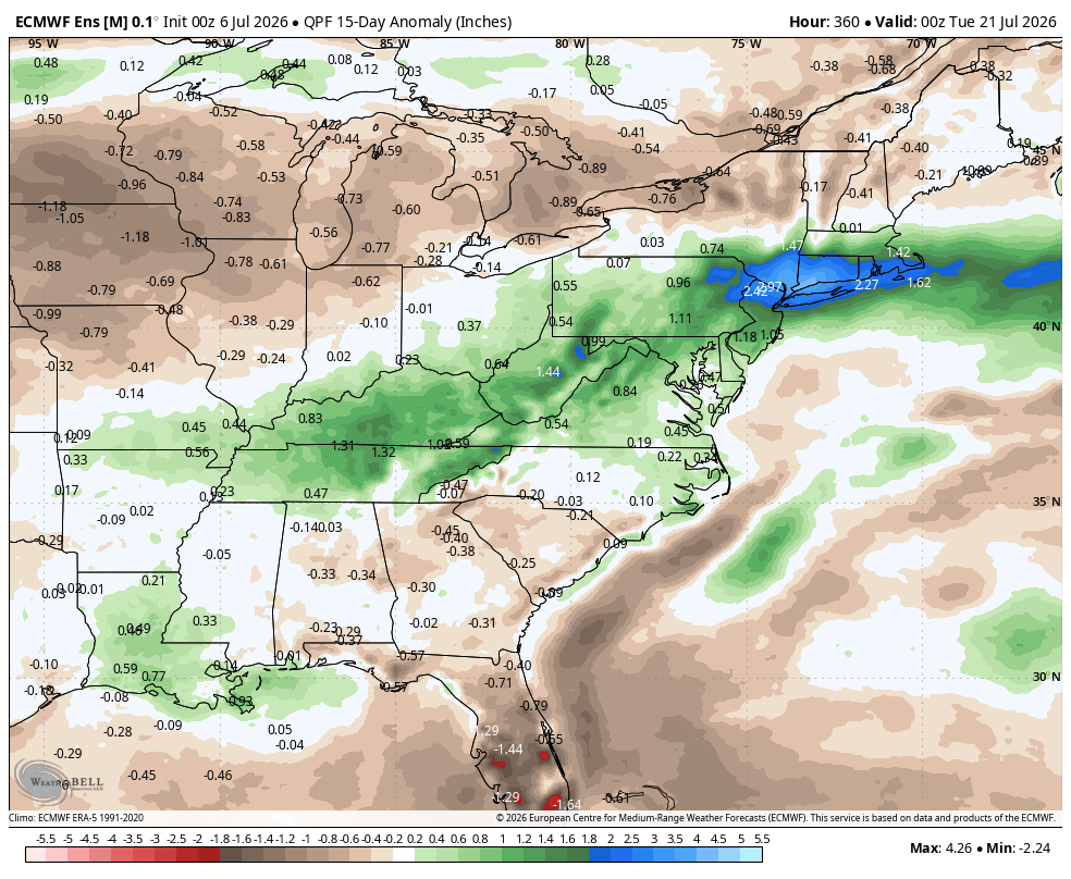
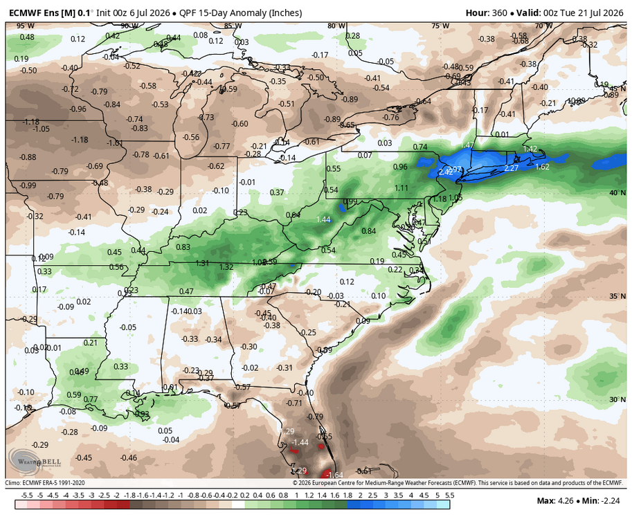
WB 0Z EPS is wet next two weeks.
-
Zzzzzz maybe .25 overnight while the HRRRRR had over 3 inches for the same period
-
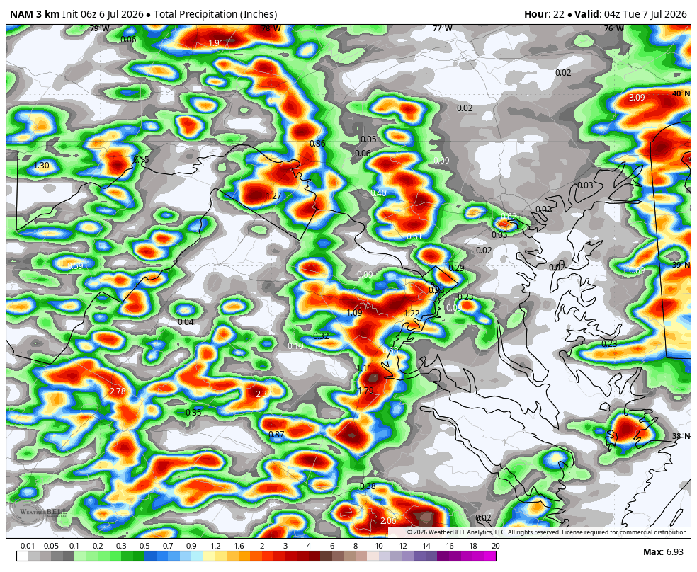
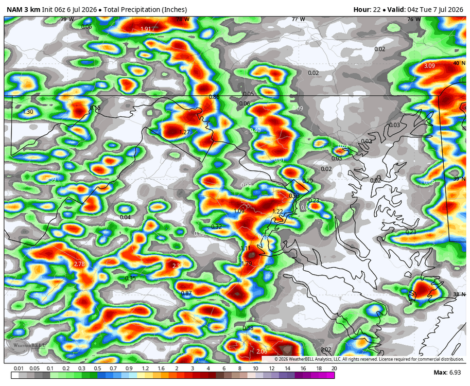
1.3 last night; best rain in forever....another round of storms later this afternoon/evening. WB 6Z 3K NAM.
-

Central PA Summer 2026 Discussion/Obs Thread
pawatch replied to Voyager's topic in Upstate New York/Pennsylvania
73 for the low up here. Got dry slotted on most of the rain only .15” of rain up here. Hope everyone gets their power back soon. What’s the old saying? When it rains it pours. -

Hoisting the Sultan Signal: Heavy Rain Event July 5-7
kdxken replied to WxWatcher007's topic in New England
Let's keep South -
2026-2027 Super El Nino
snowman19 replied to Stormchaserchuck1's topic in Weather Forecasting and Discussion
New July BOM model run for region 3.4 and region 3 -
Just a WAG, but I think this week marks the beginning of a transition to legit Niño conditions i.e. wetter and cooler than normal. We'll see.