All Activity
- Past hour
-
I’ve seen rug pulls happen even closer to the event than 3 days before.
-

December 2025 regional war/obs/disco thread
powderfreak replied to Torch Tiger's topic in New England
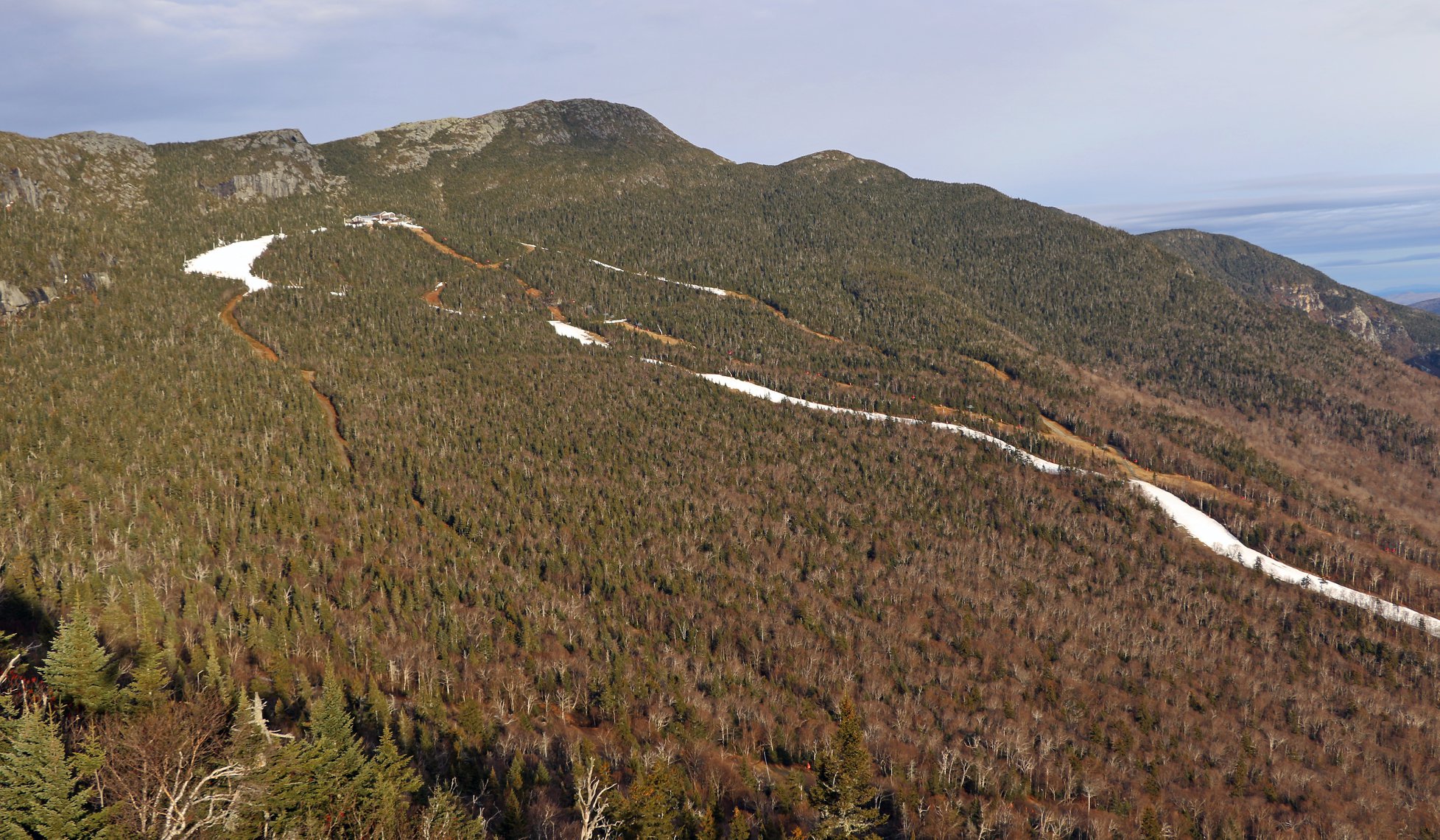
That is a crazy sequence of events in the final week to Christmas. Is it better to have loved and lost, than not have at all? This was 2015 Stowe/Mansfield on Christmas Day. Only Xmas Day since 1954 with no snow on the ground at the Co-Op stake. This November reached a higher snow depth than was seen at any point during that 2015-16 winter.
-
Nov 28-30th Post Turkey Day Wintry Potential
snowman33 replied to Chicago Storm's topic in Lakes/Ohio Valley
Climo wise, this time of year you'd expect these systems to cut hard and drop heavier snows across the Great Plains. I can't recall seeing a setup just like this in a long time with the antecedent trough over the Great Lakes. -

Nov 28-30th Post Turkey Day Wintry Potential
sbnwx85 replied to Chicago Storm's topic in Lakes/Ohio Valley
-

Fall/Winter Banter - Football, Basketball, Snowball?
John1122 replied to John1122's topic in Tennessee Valley
Looks like we may play Kansas in the 3rd place game, due to the margin of victory metric in play. -
0.36 so far
-
Im not surprised at all with the volatility from basically all the models. We had an SSW or at least a significant weakening of the PV. We also have the MJO doing its thing and it's a good thing at that. The models have had a really tough time in the mid-range this season. A lot going on in the atmospheric river.
-
 Those moths are great in spring into early summer for eating Oaks. Those are the winter moths or Silkworms , Cankerworms .and Leafrollers . There’s a few different species.. We had a huge crop the last 2-3 years here.. each one heavier than the last . Hoping for full deforestation soon
 -

Central PA Fall Discussions and Obs
mahantango#1 replied to ChescoWx's topic in Upstate New York/Pennsylvania
.39 rain today. -
The NAM is tentatively scheduled to be retired in March 2026. After a ton of delays through the years for various reasons, we finally have a time. I'd expect it may shift a bit, but the point is, the end is finally near.
-
Another fairly well modeled to overperforming event
-
 Choose and cut Christmas tree farm
 -
It's probably gonna be amazing scenery in the western UP. Heavy wet snow clinging to everything then it freezes up then fluffy drifty lake snow. 2-3 feet possible near Ironwood. Always not fair when a lake belt gets slammed with synoptic snow first. So jealous!
-

2025-2026 ENSO
donsutherland1 replied to 40/70 Benchmark's topic in Weather Forecasting and Discussion
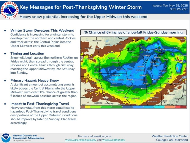
A colder pattern is now poised to develop in the Upper Midwest and Great Lakes Region. The odds of a moderate (4" or above) to perhaps significant snowfall (6" or above) in Chicago Saturday into Sunday has increased. The daily record snowfall for November 29-30 is as follows: November 29: 3.0", 1942 November 30: 3.0", 1907 Those 3.0" amounts are also the two-day records for November 29-30. Even if the daily mark isn't set on either day, the two-day figure for November 29-30 will likely be broken. In the wake of the storm, Chicago will likely have its snowiest fall since 2019 when 8.3" of snow was recorded. The snow should then spread into Detroit, Windsor, and Toronto Saturday night and Sunday. -
How many perished in srn VT?
-
100% agreed. I do not get excited for acute threats until we're inside D3 anymore.
- Today
-
Winter is coming
-

December 2025 regional war/obs/disco thread
cleetussnow replied to Torch Tiger's topic in New England

-

Nov 28-30th Post Turkey Day Wintry Potential
ChiTownSnow replied to Chicago Storm's topic in Lakes/Ohio Valley
I still say we all create the first weather model betting app.. put money on GFS vs EURO..etc. u know the models will get better in a hurry with all that competition -

December 2025 regional war/obs/disco thread
WxWatcher007 replied to Torch Tiger's topic in New England
-

December 2025 regional war/obs/disco thread
Go Kart Mozart replied to Torch Tiger's topic in New England
When Roundy speaks, I listen. This is heartening. -
.thumb.png.4150b06c63a21f61052e47a612bf1818.png)
December 2025 regional war/obs/disco thread
HIPPYVALLEY replied to Torch Tiger's topic in New England
Holy shit! That’s insane. -
November 2025 general discussions and probable topic derailings ...
HIPPYVALLEY replied to Typhoon Tip's topic in New England
Yes, moths here tonight too. -

December 2025 regional war/obs/disco thread
WinterWolf replied to Torch Tiger's topic in New England
And that’s what I was meaning last week about wire to wire…as great as 95-96 was(and it was awesome here..still holds the record), if you melt out completely like that, that’s not wire to wire imo. And yes, 95-96 came roaring back big time…and it doesn’t get any better than that season, but that melt out broke the wire to wire imo. But that’s just my interpretation. It’s like going 15-1 and then winning the superbowl…absolutely incredible season and postseason! But ya can’t say you went unbeaten/undefeated…or wire to wire. -
Cool but 7 days out. Maybe something to keep track of. I don't see a VA snow in this one.