All Activity
- Past hour
-
Was away all evening... 5 yo's first school dance(!) and other stuff What an amazing weekend ahead for SNE. Feeling very confident with widespread 12-20" just about all of SNE. 0z suite was excellent. @40/70 Benchmark's map was best I've seen. I share some of the tracking fatigue... the broad strokes have been locked in for days. Still some suspense on meso features (how high SLRs, OE enhancement, how much 925-850 easterly fetch can we sustain Monday to top off eastern SNE, especially north and south shore areas) that we'll need to get 20"+ totals. Check this out... will be puking snow Sunday evening:
-
 30 minutes later, skies cleared and it's now 21.2, dp 6.
 -

Winter cancelled/uncancelled banter 25/26
NorthShoreWx replied to Rjay's topic in New York City Metro
I am using a single malt. -

“Cory’s in LA! Let’s MECS!” Jan. 24-26 Disco
40/70 Benchmark replied to TheSnowman's topic in New England
The other cities seems to be Slovakian.....yea, nailed it. -

“Cory’s in LA! Let’s MECS!” Jan. 24-26 Disco
RUNNAWAYICEBERG replied to TheSnowman's topic in New England
AI maps are funny. I tried making them too and they create fake town names. -
“Cory’s in LA! Let’s MECS!” Jan. 24-26 Disco
40/70 Benchmark replied to TheSnowman's topic in New England
WTF is that? Providence is in Maine and Boston on the cape? Sea scroll? -
Euro AI has almost 2 inches of snow to downtown Knoxville now. Snow is shifting south across all modeling as we get closer to the event. Keep in mind, the Euro is a high resolution model, higher than the NAM for instance.
-
Planes landing at South Bend go right over where I work. When I was leaving I thought we had one coming right at me. I looked up and it was normal altitude, but the cold air must make the sound travel more efficiently. I thought I was going crazy but glad I’m at least not alone. Down to -6 now. HRRR has a low of -13 with snow pack and clear skies it is certainly possible. Record today is -17.
-

Richmond Metro/Hampton Roads Area Discussion
Rvarookie replied to RIC Airport's topic in Mid Atlantic
4-6 with the cold air and coming over night. Sprinkle in some sleet and ice to mash it down -
Euro gives us a Lil clipper after Sunday's storm and thats it. Seems we can do better with to weeks below freezing.
-
“Cory’s in LA! Let’s MECS!” Jan. 24-26 Disco
40/70 Benchmark replied to TheSnowman's topic in New England
Yea, east is right off of the ORH hills...downslope-city. -

January 2026 regional war/obs/disco thread
78Blizzard replied to Baroclinic Zone's topic in New England
Euro has a nice snowstorm for the Cape on Friday. -

Jan 24-26 Weekend Snow and Sleetfest Model Thread Part Tres
nj2va replied to H2O's topic in Mid Atlantic
Latest map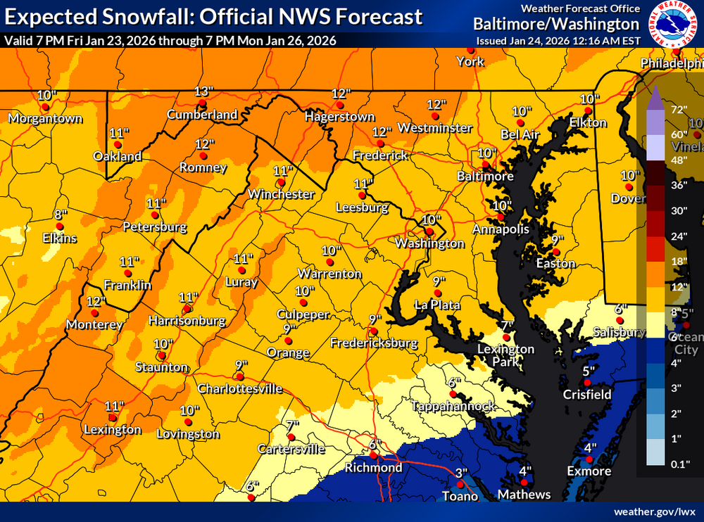
-
January 2026 regional war/obs/disco thread
40/70 Benchmark replied to Baroclinic Zone's topic in New England
Naso much. -
https://www.jdjweatherconsulting.com/jan-22-23-2005 I hated that storm, technically we got like 16" but it felt like 6. S- the whole time. And I look at the radar and it's like how did anyone in CT get over 10 looks like a 6-10 event at the most based on the radar.
-
“Cory’s in LA! Let’s MECS!” Jan. 24-26 Disco
40/70 Benchmark replied to TheSnowman's topic in New England
Oops, missed the map. -
This forum is terrible with the ads when you aren’t logged in. Wasn’t sure where to post this so figured I would reply to this thread lol. Not as bad once logged in.

-
5 here as well; looks like the sub-zero readings are in NePA headed this way. The colds coming in from the northwest, as opposed to due north.
-

Jan 24-26 Weekend Snow and Sleetfest Model Thread Part Tres
pazzo83 replied to H2O's topic in Mid Atlantic
16/-11 - this might be the lowest dewpoint I've recorded at my station -
.thumb.png.4150b06c63a21f61052e47a612bf1818.png)
January 2026 regional war/obs/disco thread
HIPPYVALLEY replied to Baroclinic Zone's topic in New England
There is anther big dog coming in the next 10 days. Plenty of cold and active pattern. -

“Cory’s in LA! Let’s MECS!” Jan. 24-26 Disco
Ginx snewx replied to TheSnowman's topic in New England
Huh? I'm not sure what you mean. I have had 15 to20 for 8 days -

Jan 24-26 Weekend Snow and Sleetfest Model Thread Part Tres
ErinInTheSky replied to H2O's topic in Mid Atlantic
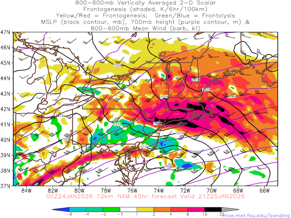
So I know the Euro has been struggling/struggles with sleet/zr. I notice on the latest run, its showing 0.8" zr. Which is obviously not the case. I guess my question is, what is that likely going to be, sleet? and how much would 0.8" zr translate to sleet? -

Jan 24-26 Weekend Snow and Sleetfest Model Thread Part Tres
Brianonymous replied to H2O's topic in Mid Atlantic
Just touched 18f here -
“Cory’s in LA! Let’s MECS!” Jan. 24-26 Disco
HIPPYVALLEY replied to TheSnowman's topic in New England
I'll do better monday if it's a more NE fetch of moisture getting thrown back vs a straight E -> W. The angle of that dangle matters here because Greenfield can occasionally get bonus snows on tilted moisture getting thrown back over the Monads and hills to my NE. -

1/24-1/25 Major Winter Storm - S. IL, IN, and OH
sbnwx85 replied to A-L-E-K's topic in Lakes/Ohio Valley
I think IWX upgrades watch to a warning then puts rest of its counties under an advisory for 3-6”. Although Berrien and Cass get that amount later with lake effect