All Activity
- Past hour
-
clear blue skies and no smoke like the previous northwest flow heat waves,,,,,,,,,,,
-
I remember in my younger days we called them the Dog Days of August. I believe the Almanacs called it the Dog days of Summer. As always …..
-

2026-2027 Record-breaking El Nino
jaxjagman replied to Stormchaserchuck1's topic in Weather Forecasting and Discussion
This dont ATM seem to look anything like 2015-2016 Strong NINO. The strong Nino during this time started early in 2014,during 2015 the Walker Circulationn got funky and just as much the Hadley.You saw much stronger trade winds blowing off South America.Compared to 82-97,those NINOs were Central and East Based,2015 was central and west based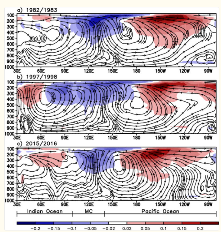
-

Augdewst 2026: Summer's Last Stand
weatherwiz replied to Prismshine Productions's topic in New England
You would think with the increasing dews and longevity of higher dewpoints (we'll say 70+) that would yield potential for stronger and more widespread events but that has not been the case. This is more thought so data could prove otherwise, but it also seems like summer cold fronts have a tendency to be weaker (which would make some deal of sense given a warmer Arctic). Just from memory though with the 90's it felt like these periods of excessive dews were much less common and we had to wait until like August to really get them. When we did get those hot and humid days the duration was barely heat wave criteria and it would end with a strong front, a big line of storms and then we would have a stretch of days with 70's to lower 80's and dewpoints in the 50's. We'll probably eventually cycle back but the dataset is so small its hard to say what the return rate for such a stretch is. Maybe there is a bit of luck involved too. It seemed like we timed good EMLs with fronts pretty well from the mid-to-late 90's and then went forever without a good EML event. -

2026-2027 Record-breaking El Nino
forkyfork replied to Stormchaserchuck1's topic in Weather Forecasting and Discussion
the cold has been concentrated near the pole while the mid latitudes have been on fire -

2026 Mid-Atlantic Severe Storm General Discussion
Eskimo Joe replied to Kmlwx's topic in Mid Atlantic
Normalized CAPE and 12z RAOB from IAD/RNK/PIT would argue skinny CAPE profiles. Shear is also pretty weak too, but the 1.8" - 2" PWATs would suggest isolated flash flooding is the bigger risk, especially around any surface boundaries. -

Mountain West Discussion
mayjawintastawm replied to mayjawintastawm's topic in Central/Western States
Aaaaand... I'm now in D4 drought, first time in my life I think I have been there. A 30 foot tall, 45 year old pine in my yard is dying from lack of water, trying to save it. -

2026-2027 Record-breaking El Nino
40/70 Benchmark replied to Stormchaserchuck1's topic in Weather Forecasting and Discussion
I could totally see double digit + departures in December. -

Augdewst 2026: Summer's Last Stand
CoastalWx replied to Prismshine Productions's topic in New England
I remember so many of those storms growing up when I was a kid. If not over me, then nearby. Even the 00s were good. I can't find a good scientific explanation, but convection has really been lame since 2015. Although I will say my hood has had a few doozies with wind damage...but I mean from an overall perspective. -
Augdewst 2026: Summer's Last Stand
40/70 Benchmark replied to Prismshine Productions's topic in New England
Good summer? -
Its disgusting outside
-

Augdewst 2026: Summer's Last Stand
SouthCoastMA replied to Prismshine Productions's topic in New England
86/77.5 things sticking to every surface -

Central PA Summer 2026 Discussion/Obs Thread
canderson replied to Voyager's topic in Upstate New York/Pennsylvania
Yea it’s suffocating out - humidity level here is a whopping 76%. -
Don't know the exact number but I think numerous locations were between 115-120 at least. Was just nasty.
-

E PA/NJ/DE Summer 2026 Obs/Discussion
JTA66 replied to PhiEaglesfan712's topic in Philadelphia Region
I stepped outside so you don’t have to… 88F/DP 76F -
Same here. Never felt it more nasty HI wise before or since. It was stifling beyond words. You literally could not take 10 steps with starting to drip sweat.
-
Heat index of 129 I believe
-
should be interesting around here later today - expect severe watches and flood watches
-
Well, clearly I’m more lazy than you.
-
He did not post it, and I was lazy to dig further. My bad.
-
¡Excelente! ¿Dónde está febrero?
-
 Buy Cialis online Generic Cialis without a doctor prescription - Generic Cialis price
 -
If I order a cheeseburger and I bite into a SLICE OF KETCHUP, I am puncturing the owners tires. What in the actual HELL is that abomination?
- Today
-
The hottest day of my life.July 15th 1995..was at an outdoor party..temp 102 dewpoint 83. It was so hot I had to go inside,take my face and plant it on the AC for relief..Heatwave killed hundreds in Chicago