All Activity
- Past hour
-

Extended summer stormlover74 future snow hole banter thread 23
forkyfork replied to BxEngine's topic in New York City Metro
i'm more excited by +20 850s at day 10 than universal agreement for 18" at hour 12 -
Spent the last few days in Vegas roasting in the record breaking 110 degree heat, warmest air temps I’ve ever experienced. Coming home to breezy low 70s and dews in the 40s feels amazing.
-

2024 Atlantic Hurricane Season
Tallis Rockwell replied to Stormchaserchuck1's topic in Tropical Headquarters
Hopefully we get 2020-esque where we get whole lot of more moderate cyclones than stronger ones. A busy June and July could keep these temperatures from rising to even more insane levels come August or September. -
Geoloction options for Radar....
-
NWS Fullscreen Hi-Rez option...
-
Awesome, happy to share and glad that others enjoy.
-

Spring/Summer '24 Banter and Complaint Thread
Chambana replied to IWXwx's topic in Lakes/Ohio Valley
Seems the forest preserves have them THICK. Been to two of them in two weeks, and heavily ambushed with cicadas, here in Champaign? Nothing. -
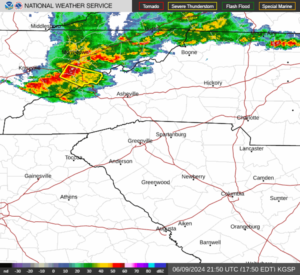
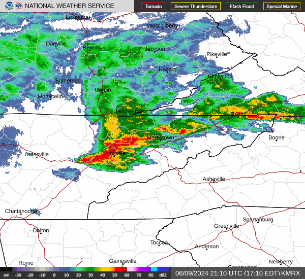
Yeah this line really blew up as it got into eastern Tennessee.
-
Just checking this out. Looks rough!
-
It's coming Sent from my SM-G998U using Tapatalk
-
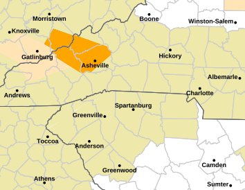
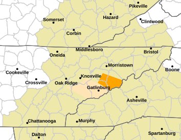
Severe Thunderstorm Warning for... Southern Madison County in western North Carolina... Northern Haywood County in western North Carolina... Buncombe County in western North Carolina... * Until 700 PM EDT. * At 604 PM EDT, severe thunderstorms were located along a line extending from 7 miles east of Newport to 9 miles east of Gatlinburg, moving southeast at 50 mph. HAZARD...70 mph wind gusts and penny size hail.
-
Severe Thunderstorm warning. Sent from my SM-G998U using Tapatalk
-
High today of 94 before the clouds moved in. Dew points quickly climbed from the 50's of yesterday to the upper 60's today. They have since rose to the low 70's.
-
Looks like these storms might be going severe. Sent from my SM-G998U using Tapatalk
- Today
-
After some showers, the clouds broke making for a partly sunny and pleasant afternoon with readings in the 70s. The pleasant temperatures will continue for several more days. Through Tuesday, temperatures will top out in the middle and upper 70s in much of the region. Minimum temperatures will be in the lower 60s in New York City and 50s outside the City. A warming trend will likely commence after midweek. Afterward, the potential exists for a long stretch of above normal temperatures. Following New York City's 4th warmest spring and Philadelphia's 6th warmest spring, there is a distinct possibility that June 2024 will rank among the 10 warmest Junes on record in both cities. Records go back to 1869 in New York City and 1874 in Philadelphia. The latest summer guidance continues to suggest a warmer to much warmer than normal summer lies ahead. The ENSO Region 1+2 anomaly was -1.1°C and the Region 3.4 anomaly was +0.1°C for the week centered around May 29. For the past six weeks, the ENSO Region 1+2 anomaly has averaged -0.48°C and the ENSO Region 3.4 anomaly has averaged +0.35°C. Neutral ENSO conditions are underway. The neutral ENSO will likely evolve into a La Niña event during the summer or perhaps early fall. The SOI was -20.74 today. The preliminary Arctic Oscillation (AO) was -1.348 today. Based on sensitivity analysis applied to the latest guidance, there is an implied 81% probability that New York City will have a warmer than normal June (1991-2020 normal). June will likely finish with a mean temperature near 75.1° (3.1° above normal).
-
Looks like some pretty decent storms going to blow through. Sent from my SM-G998U using Tapatalk
-
 So are the nights getting warmer in the Philly burbs (I actually thought they would show this) but as with all of the temperature analytics - very cyclical with a cooling trend in excessively high nighttime lows over the last 2 complete decades.
-
Hey GaWx See the below with # of average lows by station over 75 degrees since 1900....a bit surprising to me but as with most of our metrics - very cyclical with a clear trend to less warm nights over the last 2 decades.

-
There have been another two days of steep rises with the latest WCS PDO all the way up to -1.70. It was ~-3.00 just one week ago! But it still looks like merely a big deadcat bounce after the prior plunge. The NOAA PDO is likely still down near -2.5 to -2.75.


-

Summer-Fall 2024 Weather Disco Med/Long Range
John1122 replied to John1122's topic in Tennessee Valley
The rain today is once again free of thunder in my area but it absolutely poured down those huge drops, caused minor street flooding. Looks like we get hot late week and next weekend. Was hoping we'd make it through June without feeling it.- 11 replies
-
- 2
-

-
- heat
- thunderstorms
- (and 7 more)
-
Another day with 45 mph winds. Seems like the past several years have had more very windy days (40 mph+) than we used to have. Feels like we live in Kansas now sometimes.
-
The heat for the eastern lakes keeps getting pushed back. The hype for this summer being hottest in years in the local media means the population will lose more trust of these seasonal forecasts.
-
Nice soak earlier. About .60". Heavy showers passing overhead now with the first distant rumble of thunder of the season.
-
Coming week looks better. Need warmer nights. That'll kick stuff into overdrive.