All Activity
- Past hour
-
 Fish gone wild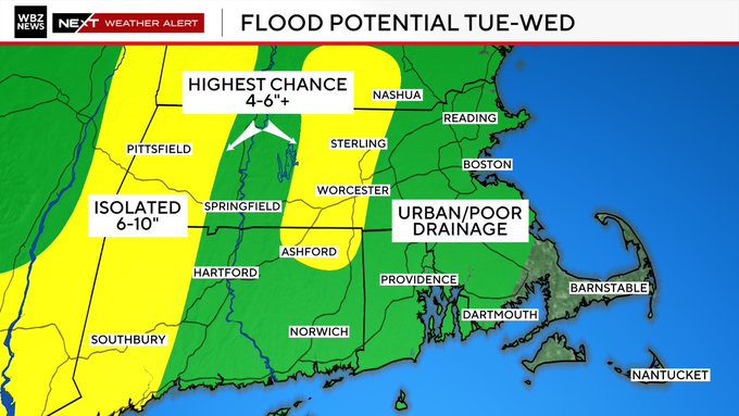
-
 liking just E of ORH hills for second jack
 -
 Expecting 1-2” here . Decent rain but more boredom
 -
 Peels all the soil off Mt Tolland…
 -
2026 Mid-Atlantic Severe Storm General Discussion
Roger Ramjet replied to Kmlwx's topic in Mid Atlantic
Powers out and I have trees down. Lucklly not on the house.- 1,578 replies
-
- 1
-

-
- severe
- thunderstorms
- (and 7 more)
-
That always shows up during precipitation/storms
-
Heavy rain with gusty winds at the moment.
-
 Ya that’s our opportunity to get bad , if that trains it will be trouble. On a side note the local min golf spot in Oxford just reopened this month and they almost had another disaster last week with the 2” in 1 hour rainfall. They showed me pictures from the ‘24 flood and then last week when the river rose about 10’ in an hour and the mini golf is literally on the river about 15-20’ above it a dangerously close call.
 -
 Maybe it’s closer to Western CT, but you gotta remember Low will develop later on tonight and at night as that happens the LLJ increases just saying to watch that area that’s all. Maybe it’ll be more progressive.
 -
 more tenuous out this way..need some luck getting in on the convection from the south east
 -
.65” with the first round
-
Yep, no go here. Can’t even get a cumulus cloud to pop. Just feels stable out. That area in SW NC might be in the game though
-
I just spent as far as SNE goes. We’ll see.
-
Ya looks like swct will get mostly shut out today and tomorrow could be progressive. I wouldn’t mind missing the flash flooding
-

2026 Mid-Atlantic Severe Storm General Discussion
Maestrobjwa replied to Kmlwx's topic in Mid Atlantic
I read this and immediately heard the classic chaptic *reowwwwwww!* Haha- 1,578 replies
-
- 1
-

-
- severe
- thunderstorms
- (and 7 more)
-
Wierd echo moving west on lwx south of Annapolis. Gotta be either range folded, or a spacex rocket failure.
-
Spotter reported golf ball sized hail in Clarke County at 418pm
-

2026 Mid-Atlantic Severe Storm General Discussion
DanTheMan replied to Kmlwx's topic in Mid Atlantic
Im about to get clocked. Just tossed the cat in the basement ahead of me- 1,578 replies
-
- 3
-

-
-
- severe
- thunderstorms
- (and 7 more)
-
He means like when there are 10 counties in the warning
- 1,578 replies
-
- 1
-

-
- severe
- thunderstorms
- (and 7 more)
-
Looks like coming across Chimney top Mt might have messed up its circulation: https://i.imgur.com/LHc2SAr.mp4 I tried to catch it on TDOT cameras, but the closest one "Dark Hollow Rd" was aimed north at the time.
-
2026 Mid-Atlantic Severe Storm General Discussion
Maestrobjwa replied to Kmlwx's topic in Mid Atlantic
Mega warnings? -
Need to watch that junction point for tornado risk
- 1,578 replies
-
- 1
-

-
- severe
- thunderstorms
- (and 7 more)
-
Got hammered once again here in North Haledon, NJ (Eastern Passaic County) with 2.04". Rain started here about 3:30, which became heavy by 3:35 and torrential by 3:45. Lots of thunder and lightning. Highest gust was about 18 - 20 mph. All this after receiving 2.55" yesterday. As of 4:43 pm, the 2 day rainfall is 4.60".
-
Okay, I can't ever recall seeing a line of storms form perpendicular to the main line and almost connect to it. That is a very odd radar to see out near Frederick.
- 1,578 replies
-
- 1
-
-
- severe
- thunderstorms
- (and 7 more)
-
Back home is under a Severe Thunderstorm Warning. Meanwhile got changed to a Tornado Watch over here in DE. Seems to be Tuesdays for storm days these last 2 weeks.