All Activity
- Past hour
-
I just watched Jim Cantory say that it seems to be trending more towards a LA landfall. That's more in our wheelhouse for remnant moisture than Texas. That will just mean Frederick and Glen Burnie get flash flooding lol
-
Almost expect to wake up to one of those every day right now. Since it started we haven't missed a day yet. Hoping some day this week will not have an air quality alert!
-

Central PA Summer 2026 Discussion/Obs Thread
Superstorm replied to Voyager's topic in Upstate New York/Pennsylvania
56F low in Lancaster. . -

Central PA Summer 2026 Discussion/Obs Thread
mahantango#1 replied to Voyager's topic in Upstate New York/Pennsylvania
53 here this morning. -
 Yeah unless we’re getting 10” of rain in a month and a bunch of 60-70° ratters it’s tough to pull off BN summer months now…even with 1991-2020 normals. CON had 14 mins in the 40s or colder in July 1965 and an extreme of 35°. That’s hard enough for SLK to pull off today.
 -
not much has changed on this front
-
Point/click has my rain chances for tonight through Wednesday night of 60%, 70%, 90%, 80%, 80%. I'm calling it now: less than 0.2 total and a total whiff wouldn't surprise me. Too bad that new depression in the Gulf is expected to move west towards Texas. A tropical system up the coast is the only way I can think of that would get real rain here.
-
Seems like Upton is discounting the widespread regional flood threat for tomorrow and Wednesday. Thoughts ? AFD from KOKX
-
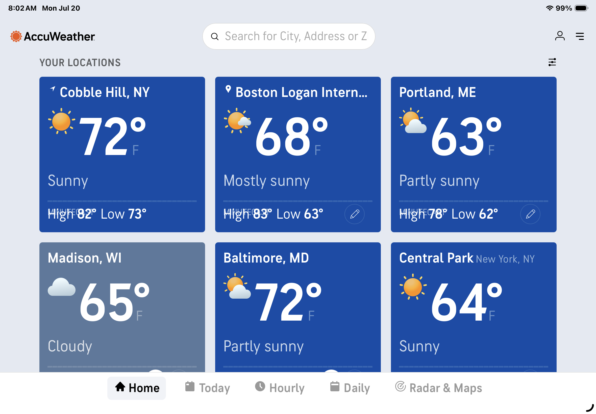
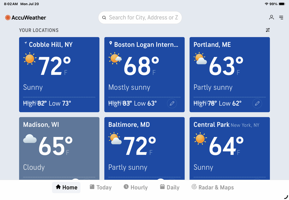
72 in my UHI blessed Brooklyn postage stamp as opposed to 64 at Central Park, probably due to natural air conditioning. As always …
-
 Gardeners and farmers don’t forget the year ago pattern. It’s imprinted on us like a scar. A few of us here fit that mold.
 -
If you want to make a cogent background warming argument it’s that we have BN persistence in the northeast but N to AN tendency.
- Today
-
Highly doubt that persists through winter.
-
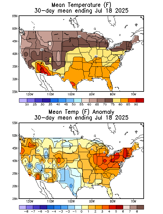
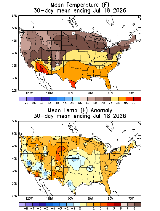
 The season is not record hot/cold until it's over. Let's' see how the remainder plays out.
 -

Central PA Summer 2026 Discussion/Obs Thread
pawatch replied to Voyager's topic in Upstate New York/Pennsylvania
54 degrees this morning. Awesome morning! Anyone have an idea when this storms are supposed to start up tomorrow? -

2026-2027 Super El Nino
bluewave replied to Stormchaserchuck1's topic in Weather Forecasting and Discussion
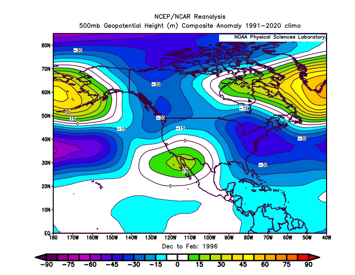
94-95 was close to what the Euro seasonal was forecasting and not what verified. The closest actual 500 mb match was a much warmer nationally and less snowy version of 1995-1996 for DJF. Notice how the ridges overpowered the pattern compared to 1996. It was the first weak La Niña since then with a Bering Sea ridge, Baja SW U.S. ridge, and Greenland block. This has been a common theme regardless of ENSO in recent years. Ridges have been growing stronger and more expansive. The spring pattern quickly flipped to the standard 2020s pattern.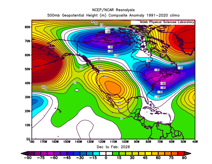
-
CIPS is not super-honking (the threat is there - it's just more muted). If nothing else - I am hoping for an event where I am working from home for a change (or at least in the area...) That said - a confirmed TOR passed near me up in PA Saturday evening (the Houtzdale/Whiteside, PA one confirmed by CTP). Was a few miles away.
- 1,178 replies
-
- 2
-

-
- severe
- thunderstorms
- (and 7 more)
-

2026 Mid-Atlantic Severe Storm General Discussion
high risk replied to Kmlwx's topic in Mid Atlantic
There has been a clear trend in the guidance for more favorable timing for our area.- 1,178 replies
-
- 3
-
-
- severe
- thunderstorms
- (and 7 more)
-

2026-2027 Super El Nino
donsutherland1 replied to Stormchaserchuck1's topic in Weather Forecasting and Discussion
The weekly ENSO Region 1+2 anomaly rose to +3.6°C during the week centered around July 15. Only the 1982-83 and 1997-98 super El Niño events saw comparable or higher values. The last such anomaly occurred during the week centered around December 24, 1997 (+3.6°C). A strong El Niño is ongoing. -
 Both but people have the weather memory of a goldfish. A couple cooler days and suddenly they think summer hasn't been record hot.
 -
Quite nice this morning. Low of 64 imby.
-
Nah. Tuesday/wed is part of the banner. Wall to wall sun is too much of a good thing. Need the rain to keep the landscape happy and the water bills in check.
-
https://www2.mmm.ucar.edu/projects/ncar_ensemble/ainwp/?fbclid=IwZXh0bgNhZW0CMTAAAR3_KcoSRHWhY1lxCTCfOqSNC0AD8SUSmL_c7R_N8rtpvo-PsNNvuY3vuI4_aem_Stpgx3ntIqB8IVErFY76cQ Not posting individual maps since there are many toggles from the NCAR page - but NCAR highlighted areas would argue for continuing to shift the ENH eastward if it is correct.
- 1,178 replies
-
- 1
-
-
- severe
- thunderstorms
- (and 7 more)
-
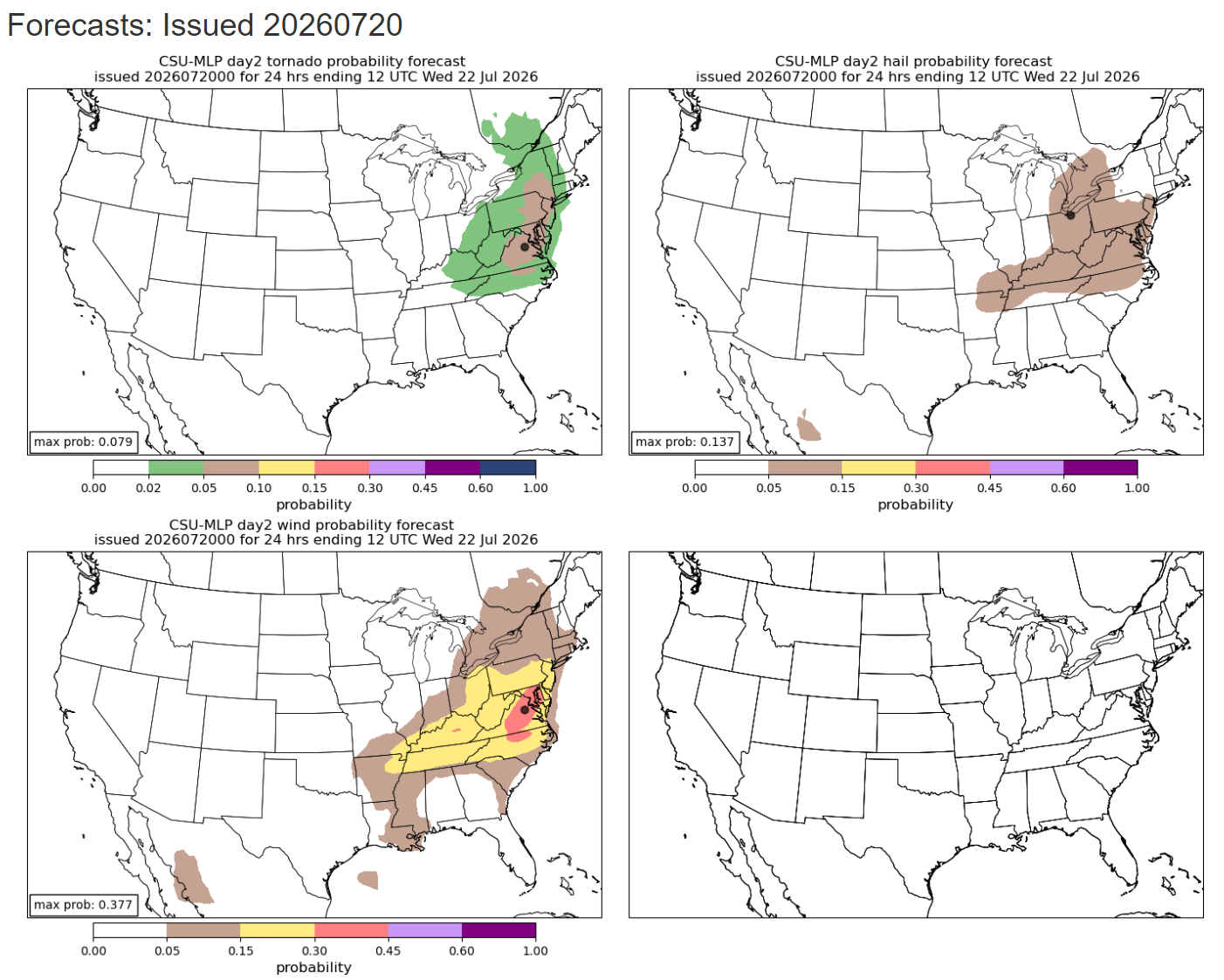
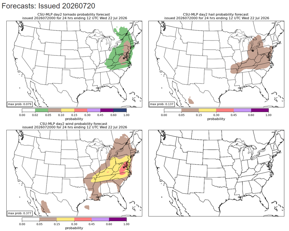
Latest CSU MLP guidance
-
Is this for Jersey or New England?