All Activity
- Past hour
-

January 24-26: Miracle or Mirage Thread 2
SomeguyfromTakomaPark replied to mappy's topic in Mid Atlantic
Yeah I wonder how accurate these ptype algos are? Tons of freezing rain on these things.... -
Is it also fair to say it's handling of the CAD also makes it's handling of the surface low track suspect as well?
-

Possible Record Breaking Cold + Snow Sunday 1/25 - Tuesday 1/27
Prue11 replied to TriPol's topic in New York City Metro
Don what time do you think the previous ends in nyc/li area Monday? -
And so, as expected, the GFS is out enjoying a Pina Colada on its island. Uccinelli was right. Only thing we can really hope for is a turnaround as things get closer - a faster system that lets the confluence stick around or confluence that sticks around longer.
-
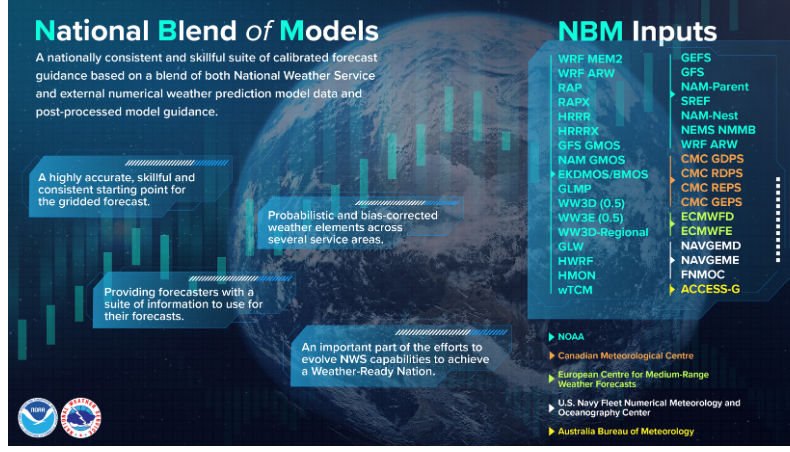
Not just those. This is an older image, but gives a great summary of the NBM inputs.
-

January 24-26: Miracle or Mirage JV/Banter Thread!
SnowenOutThere replied to SnowenOutThere's topic in Mid Atlantic
Love to extend the scroll length of a page by twice its normal amount -
Meh- once you take 12+ off the table; additional shifts don't yield that much less snow. Its would take shifts of hundreds of miles to skunk on anything less than 6 inches. So just set expectations accordingly. This is probably 6-9 for the metros followed by sleety.
-
We have Real Feels at -40F next Thursday on the Euro. Probably could put that in the pattern thread, but that might affect people who are affected by the storm.
-
That would be a bit of a disaster for the public
-
ECM is evolving into something less impressive not liking it 6-10" snow thump 1-1.25" frozen sleet and stuff and dryslot GFS is a MECS
-
After this current storm... Probably good it's south and east at this point
-

January 24-26: Miracle or Mirage Thread 2
NorthArlington101 replied to mappy's topic in Mid Atlantic
I agree - was hoping that would lead to a downstream outcome more like the GFS. I believe some of the nerds I listened to saw some positives at h5 in the Euro, but it ended up being drier and flipping us at essentially the same time. So kinda meh overall. Gonna be on repeat all the next 2 days mostly to convince myself but I think I'm fine with 5" then sleet storm. -
Every model run at this point will be interesting.
-
Some of the hi res models will prob start showing it tomorrow at some point.
-

Possible Record Breaking Cold + Snow Sunday 1/25 - Tuesday 1/27
Joe4alb replied to TriPol's topic in New York City Metro
100% -

2025-2026 Fall/Winter Mountain Thread
strongwxnc replied to Buckethead's topic in Southeastern States
Sitting inside the 1" total here in Rutherford. Lord -
Synoptic Overview 3 Well, we’ve made it. At this point our synoptic scale features are more or less set in stone and all we will see are some minor shifts; however, small shifts aloft may be the determining factor between who gets 6 inches of snow/sleet and who gets 20 inches of snow. I will start off the review with our key changes since my last outlook two days ago, I will then progress over the synoptic setup of this storm and the relationship it has with our thermals. Additionally, I will mention the features we want to see shift around to get a snowier outcome. This Overview is made with the 12z runs minus the Euro, though atp you can apply it to any model. Important parts of this overview will be bolded. Part 1: Major Changes since Tuesday 1. Further West and Stronger NS 2. Less Confluence 3. Further West Storm Track 1. Further West and Stronger NS This feature has been the largest factor in eliminating our suppression concerns and replacing them with amplification concerns. We have seen a consistent further west progression of our NS vort which phases into our SW sooner and more completely. For example comparing our recent Euro run with one that smoked the whole area without mixing concerns we can see the difference in our NS. Lets start with the old run Clearly this will still be a nearly full phase, yet the westward movement of NS becomes apparent when compared to our recent runs (6z) Honestly, it's not an absolutely huge change but it's more than enough to allow a complete capture of the SW which leads to higher heights out front. We can also see that the western edge of our vort, which runs N to S, is a good bit more intense which only aids in amplification. However, this change out west is only one part of the picture, and on its own it would’ve acted to probably give us a HECS run. Unfortunately, its not the only change that occurred… 2. Less Confluence This is the second piece to our puzzle that explains the relatively rapid shift to our NW that threatens to skunk SW VA and points south-east. Once again lets look at the Euro run comparison but focus our gaze on the Northeast. Once again our old run of the Euro has a pretty major difference. We see the confluence right over Maine thanks to a NS disturbance over Canada. That is a great setup to force our amped storm south. Welp, the latest Euro shows us our problem. Those disturbances which gave us that confluence is pretty much gone. Additionally, we can see that the more powerful NS is able to pretty much dominate the pattern further East as it doesn’t have those disturbances to counteract it. With a run like this we don’t have that same active mechanism to prevent the storm from cutting into the TN valley. At this point its probably too late to get those disturbances back (besides I think their disappearance is in part an absorption into our NS lobe) so we need to hope that instead the overarching 50/50 low comes back west some. Now lets put headlines 1 and 2 together. 3. Further West Storm Track Of course, the two causes I outlined have far more complexity then what I am able to understand, but putting them together gives us a good enough picture of what has happened. Let's look at the old North America 500mb maps We can see our 50-50 low and the block over Greenland. Additionally, we can see the disjointed phase that the storm is undergoing in the plains. With a look like this we were golden as they managed to balance between the southeast ridge which allowed the storm to hit us, and overamplification which would mix in ice. Our new run shows how factors 1 and 2 really hurt us. We have a stronger, more consolidated storm out west which on its own would pump the East coast heights. Then that is combined with a shift east of our 50-50 low due to less blocking over Greenland and well, it's clear why we're going to mix. Additionally, you can see the little disturbance that pokes west of the main 50-50 and how its now up near Greenland instead of further south over Canada, I suspect that this is a sneaky reason for why our confluence has collapsed so much. A vort map shows this sneaky disturbance better. The old run shows a weaker NS and generally the 50-50 low as the dominant factor as there is no secondary disturbance in the flow. Our new run has a stronger NS which on its own would raise heights but we also see a new lobe of vorticity over the Canadian islands. This energy was previously part of our 50-50 and instead it now acts to amplify our storm some (or at the very least does nothing to stop it). As for implications of this shift, let's get into that with our current breakdown of the storm. Part 2: Synoptics and Thermal Impact During The Storm. Let's start with the basics, we are dealing with a warm air intrusion aloft centered from 850-700mb. This means our surface temps don't matter too much, but instead we need to focus on our winds throughout these layers and how synoptics impact those. First Phase and SW Opening (Hours 36-54) This part of our storm is more or less set in stone and rather uninteresting. We see our SW get opened up by an initial influx of NS energy which sets our storm traveling east. The Euro at hour 36 shows us that our SW is still closed, but vorticity over the Pac NW will soon change that At hour 54 this process is complete and we begin to see the second part of our storm period enter the picture. That being the NS dropping south. Second Phase and Initial Thump (54-84) Let's start from the top down in the atmosphere. At hour 63 we can see the changes outlined in our key points taking effect. Our NS is backed up further west and captures our SW further west leading to higher heights in conjunction with the loss of confluence. Now what happens thermally in response? Well all thermal stuff can be traced back to winds induced by cyclogenesis. Look at our recent 6z Euro run and its wind flow at the 850 level (wind is blowing across isotherms as such it is advecting that temperature into the area it is blowing). Compare this to colder runs and its quite apparent what has happened. Our wind field used to be a couple hundred miles south and oriented differently! We need to watch how strong the winds are on the CAMs as we get closer to the event. We want to see a flatter area of high speed 850s from the south. Progressing our storm forward some and we get this H5 map Looking back at our 850 map we can see how the H5 level translates into cyclogenesis East of the H5 low. See the closed isobar already formed, of course, winds will flow cyclogenically which then puts us in its warm sector and eroding our upper level cold air. We need less phasing because it shunts the cyclogenesis south. Or we need more confluence as it prevents the winds from reaching as far north. Now finally, let's connect this to the surface with FGEN and precip. We can see how these winds translate to FGEN, and then subsequently this induces lift and boom! Snow! In order to get this to stay colder we want less intense 850-700mb winds as that will prolong our cold air reserves and still allow for FGEN as we will have WAA regardless. Coastal? (Hour 84 onwards) NGL, I don’t think we score on this one. Even on our best scenario which is the GFS its still really an overrunning event that manages to climb the coast based on the H5 and winds Notice how we don't get a separate coastal low aloft. We don’t really have a great mechanism to flip back to snow without that. However, for the people who are hoping for it we want a further south system with more confluence to force a quicker handoff. Final Thoughts (TLDR) The synoptics of this storm are locked in stone more or less. However, changes can still occur. For example, the GFS and Euro still have quite a different H5 map. Euro top GFS bottom Summing up my whole post we can see why the GFS is so much better. It has a bit less phasing which allows for an extremely strong initial thump before we start flooding our mid-levels with warm air as seen in the 850 wind (Euro top GFS bottom) As we progress towards the event it’ll be time to start looking less from H5 and more from the wind and thermal profiles. By tomorrow it’ll be time to start using the NAM and other CAMs for this purpose. We can still hope for some H5 changes as they may have significant impacts on our lower level winds; however, I think it is reasonable to say that we should expect 6+ inches of snow and several inches of sleet OR 12+ of snow with an inch of sleet for areas near NOVA. Ofc, if you are further north, situation two is more likely and possible you don't see sleet. Areas around where I am in UVA should bank more on scenario 1 happening. Conclusion It's going to snow.
-

Richmond Metro/Hampton Roads Area Discussion
wasnow215 replied to RIC Airport's topic in Mid Atlantic
Still showing the freezing rain but different people are saying that freezing rain could be sleet and that the European model doesn't do a good job with the differential. Let's hope so -

January 25/26 Jimbo Back Surgery Storm
NorthHillsWx replied to Jimbo!'s topic in Southeastern States
Right direction being an ice apocalypse in the triangle? -

January 24-26: Miracle or Mirage JV/Banter Thread!
Rhino16 replied to SnowenOutThere's topic in Mid Atlantic
It sucks to waste all this cold air on this. I don’t think I’ve been able to track a successful winter storm since I started having an interest in this field, so I have no clue what to look for aside from textbooks and stuff. It really helps me to have experienced it before. -

January 24-26: Miracle or Mirage JV/Banter Thread!
JenkinsJinkies replied to SnowenOutThere's topic in Mid Atlantic
I mean the trend isn't looking good for the higher amounts. -

“Cory’s in LA! Let’s MECS!” Jan. 24-26 Disco
mahk_webstah replied to TheSnowman's topic in New England
I think my forecast has it around four or 5° on Sunday night during the heaviest snow. Don’t think I’ve seen that since maybe 2013 or 14. -
12z Euro essentially stalls the coastal as the primary ascent from the jet results in redevelopment closer to the coast, long period of high ratio fluff results and gets the entire region above 1" QPF/15" on Kuchera.
-

January 25-26 Winter Storm Potential
The Iceman replied to Ralph Wiggum's topic in Philadelphia Region
Euro is much drier, hopefully a blip. But significantly cuts back the thump by .2-.3 LE. -
I think Ice Storm warning upstate, NEGA and maybe Transylvania, Henderson. Winter storm warning for foothills and western piedmont.


