All Activity
- Past hour
-

Winter 2025-26 Short Range Discussion
Chicago Storm replied to SchaumburgStormer's topic in Lakes/Ohio Valley
the cams ended up caving, as did the globals. in the end a split scenario was what occurred. (not to say that will be the case this go-around, though) -
3” so far at all elevations from town to upper mountain. Really no change with elevation it seems.
-

Winter 2025-26 Short Range Discussion
A-L-E-K replied to SchaumburgStormer's topic in Lakes/Ohio Valley
the pros at lot say toss that shit (the hrrr is the shit btw) -

E PA/NJ/DE Winter 2025-26 Obs/Discussion
Birds~69 replied to LVblizzard's topic in Philadelphia Region
Rain...enough said, 39F. -

Central PA Winter 25/26 Discussion and Obs
CarlislePaWx replied to MAG5035's topic in Upstate New York/Pennsylvania
Thank you for confirming what I was suspecting. For the past 30 minutes I've had a mix of light sleet and snow, but more sleet based on what it looks like on my mulch and pavers. Temp dropped from 34 down to 33.6. As far as I can tell I'm not seeing any evidence of rain...just all frozen. -
Mod snow. Sticking to everything but road. 32.9
-

December 2025 regional war/obs/disco thread
moneypitmike replied to Torch Tiger's topic in New England
What's equally funny about the melts is that we get one run of models that shows snow and suddenly all is forgotten, and it's like we live in the Northwest Territories with cold and snow all the time. -
Snowing pretty good at home. Everything covered and still have snow on the ground from last weeks storm.
-

NNE Cold Season Thread 2025-2026
backedgeapproaching replied to Boston Bulldog's topic in New England
Yea I know your in SLK, meant more that that there are probably nuances within short distances there like many terrain influenced areas of NNE. -

December 2025 regional war/obs/disco thread
Ginx snewx replied to Torch Tiger's topic in New England
High heights but wedged . Ice ice baby -

Richmond Metro/Hampton Roads Area Discussion
mikeeng92 replied to RIC Airport's topic in Mid Atlantic
More mood flakes on Friday on the euro and NAM. Just incredible lol -
.thumb.jpg.6a4895b2a43f87359e4e7d04a6fa0d14.jpg)
Central PA Winter 25/26 Discussion and Obs
Yardstickgozinya replied to MAG5035's topic in Upstate New York/Pennsylvania
Couple flurrys starting to mix in. -
Central PA Winter 25/26 Discussion and Obs
Yardstickgozinya replied to MAG5035's topic in Upstate New York/Pennsylvania
Sleet here in Fairview township. -

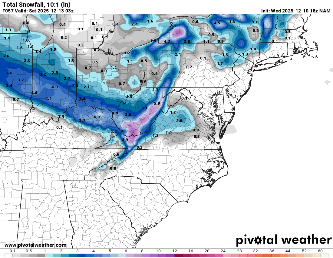
12/12: The little Friday clipper that could? Or won't.
Paleocene replied to dailylurker's topic in Mid Atlantic
I don't have the ultra zoomed in maps, but here's the cville jack on 18z NAM. maybe GFS will save points north
-

Winter 2025-26 Short Range Discussion
Radtechwxman replied to SchaumburgStormer's topic in Lakes/Ohio Valley
And cams ended up being right. 18z nam more south than hrrr but more north of globals. So might be a good compromise. Hrrr definitely the most north. But would be par for course to get missed north Thurs and missed south Sat. -

12/12: The little Friday clipper that could? Or won't.
SnowenOutThere replied to dailylurker's topic in Mid Atlantic
The morning of the 17th most likely... so just in time for the great Xmas torch! -

12/12: The little Friday clipper that could? Or won't.
NorthArlington101 replied to dailylurker's topic in Mid Atlantic
when are you coming back from finals and bringing the luck back? gotta be soon -
Today’s Euro Weeklies, after the current cold domination ends, are similar in the big picture to yesterday with a stout -PNA and mildness dominating much of the E US, especially the further south you go, into mid Jan though Jan 12-18 is slightly cooler than yesterday. That last week’s PNA is less negative. The NE US is again near normal on most maps. Mid-Atlantic is mainly mild til the last week.
-
12/12: The little Friday clipper that could? Or won't.
SnowenOutThere replied to dailylurker's topic in Mid Atlantic
Think 3k Nam sank a bit too far south but 12k NAM is a certified banger. -

Snowstorm potential 12/14/2025
Franklin0529 replied to WeatherGeek2025's topic in New York City Metro
You don't live in Buffalo. -

December 2025 regional war/obs/disco thread
RUNNAWAYICEBERG replied to Torch Tiger's topic in New England
emojis be hurting feelings… -
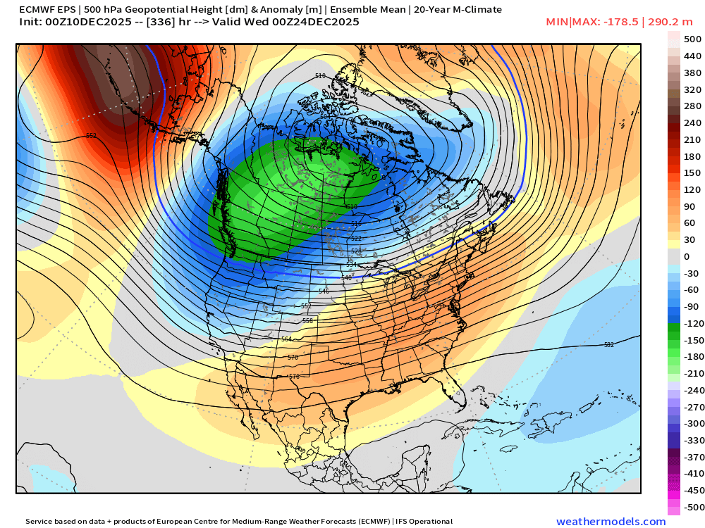
Pretty good trends today too on EPS for the Xmas period....notice how much lower the heights are in SE Canada....this is kind of what we saw in clown range on the OP run where there was a lot of ridging over CONUS but we were staying colder due to the lower heights in SE Canada. That's a trend you'll want to see keep up as we get closer if you are looking to avoid macaw parrots for Xmas.
-
I’m in Saranac Lake. You may be right about the downsloping.
-
Eventually, it becomes too warm to sustain the "normal" snowfall for the NYC metro area. While the global temperature has increased around 1.2 degrees over the last 100 years or so, our region has seen higher increases in temperature, presumably because of the slowing down of the Gulf stream/Labrador current, maybe as much as 4 to 5 degrees warmer? NYC has always threaded the rain snow line. With warmer temperature, it eventually will not matter what the storm track is...

-
12/12: The little Friday clipper that could? Or won't.
NorthArlington101 replied to dailylurker's topic in Mid Atlantic
You can see the same thing happening on the HRRR even though it works out on that model. Question is whether there is enough moisture to overcome the dry air/mountain shred. Further west has a better shot. we could in general use more north too... still a little too far south, really