All Activity
- Past hour
-
 18z mav went wild
 -
 It’s really the south wind that does BTV in. There’s like a localized nocturnal jet that can even strengthen overnight on the VT side of the Lake. You’ll see most stations calm (like Plattsburgh on the NY side of the Champlain Valley), while BTV is steady 15mph gusting 25 in like tropical breezes. And the temp will be like 86F at midnight lol.
 -
According to my records, 2026 is actually the 12th driest first half in DC history, but you are correct that the first half of 2023 was even drier, at only 12.32 inches (5th driest). Interestingly, the driest and wettest first halves in DC history each occurred in the 19th century: Driest: 1872 with 10.49 inches Wettest: 1886 with 35.80 inches It should also be noted that calendar years 2023-2025 were each drier than normal, averaging only 36.27 inches annually. However, during 2018-2022 DCA averaged 50.71 inches -- the wettest five consecutive calendar years in DC history.
-
 Yeah I just read that they've done it twice since 2018! That's damn impressive for that latitude. Maybe with a S wind and enough nightime cloud cover they pull off another one. It hasn't happened around here in my lifetime, BDL record is 79 back in 1955.
 -
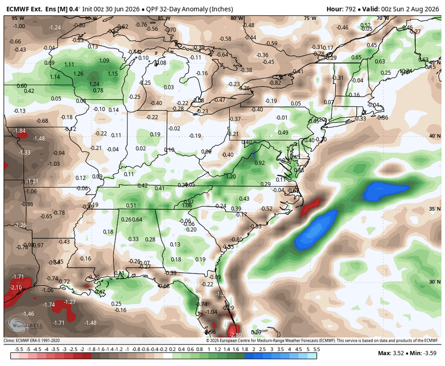
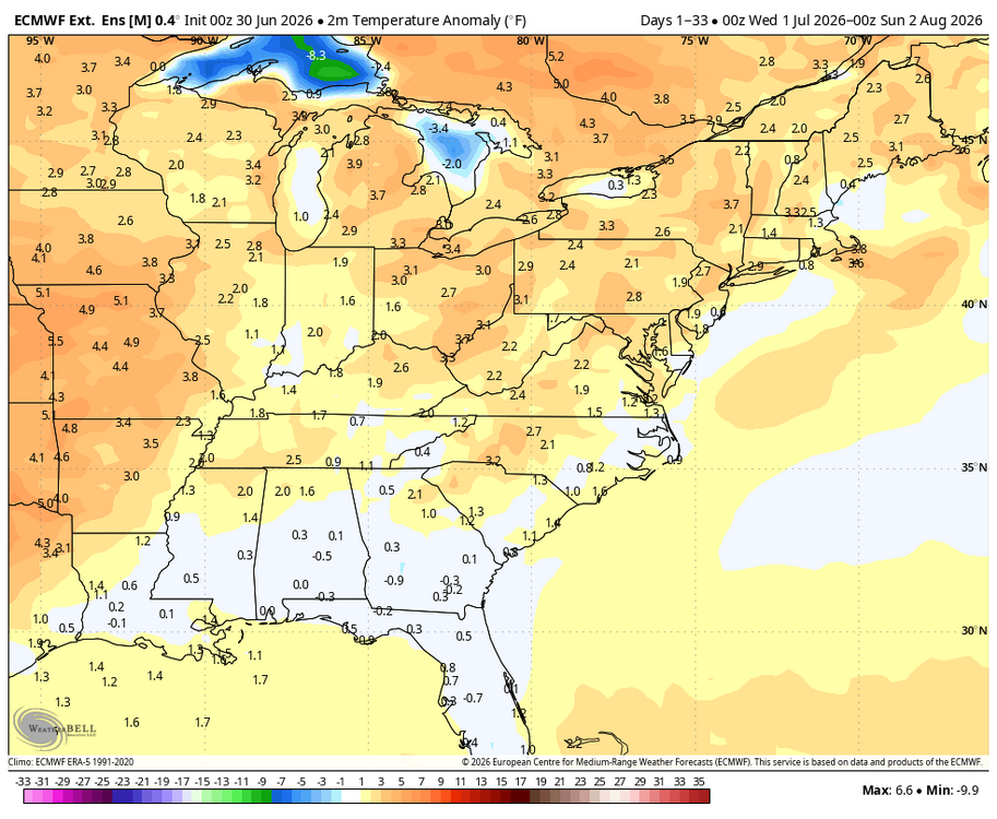
Time to start a July thread! Latest weekly EPS for July.
-
High of 90 today. 3rd 90 of the year at MSP
-
Last year it was super humid out here. We also had monsoon type rains that would blow out gravel driveways. Looks like the humidity is gonna happen again this year. First couple summers didn't have this many days of high humidity during the day. I've had to invest in dehumidifiers!
-
Feel like BTV is usually a candidate for that too in these heaters.
-
 Wonder if we have debris clouds tomorrow. Seems possible.
 -
Extreme heat watch here ( north central md) for Thursday and Friday I beleive
-
They dropped ours from 98-100, to 94-96
-
Average end of June day here. High of 89, low of 70. Month end stats: Highest temp: 98 Lowest temp: 55 Highest dew point: 84.5 Lowest dew point: 44 Rainfall: 4.55"
-
BOS is probably gonna stay above 80 Thursday night. Congrats.
- Today
-
NYC forum he was good when it used to snow.
-
DVN lowered us to 93 today, but we still came up short and hit 91.
-
That's definitely concerning
-
 DCA _ NYC _ BOS _ ORD _ ATL _ IAH _ DEN _ PHX _ SEA 2.8 2.9 2.5 2.2 1.5 0.8 2.0 2.5 1.8
 -
 July 2026 DCA _ NYC _ BOS _ ORD _ ATL _ IAH _ DEN _ PHX _ SEA 0.8 1.5 1.4 0.4 0.0 0.8 2.2 -0.4 -0.4
 -
2026-2027 Super El Nino
Stormchaserchuck1 replied to Stormchaserchuck1's topic in Weather Forecasting and Discussion
Pretty good cold air correlation in Octobers in El Nino's historically: Counter point is PDO also has a high correlation in October - negative being opposite of map below -
Late May/June 2026 Medium/Long Range
Stormchaserchuck1 replied to JenkinsJinkies's topic in Mid Atlantic
It was kind of rare to have that SE ridge with such a pattern over the Arctic and North Pacific I think the +NAO was actually the reason - that big negative anomaly exceed -400dm south of Greenland, that has less to do with ENSO -
Can I have both?
-
Earthlight
-
Brown sky
-

E PA/NJ/DE Summer 2026 Obs/Discussion
Birds~69 replied to PhiEaglesfan712's topic in Philadelphia Region
AccuWeather really going to bust on overnight lows...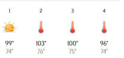
-

Late May/June 2026 Medium/Long Range
SnowenOutThere replied to JenkinsJinkies's topic in Mid Atlantic
I disagree. I’ve been an outspoken voice that what happened last winter with that storm was a travesty worse than the Feb 20th debacle of 2024. At four to five days out 95/100 permutations gave us an all time snow storm from synoptic sets, we then managed to bungle into one of the five outcomes that did not. However, the Nina shouldn’t be solely blamed for this. The setup wasn’t normal for a large snowstorm. It wasn’t a nor Easter. It was a giant lobe of energy dumped out in California that phased once to get moving east, then two NS disturbances phased, then all of that energy phased in the middle of the country. One could argue that the Nina ruined it by adding those NS disturbances but we wouldn’t have had a storm without them! A week out it looked to be a southern slider that missed south! We needed that initial phase out west and then a partial phase in the Great Plains. You need all of that energy to get a big storm. You need the NS and southern stream together. It just managed to do everything too perfectly while our NA blocking got too weak. Not to mention two other blizzards happened last winter. I think everyone knows I’m PSU’s decibel who will happily proclaim our winters suck because of climate change, but that wasn’t last year, we were just unlucky as possible.


