All Activity
- Past hour
-
El Nino and its atmospheric response seem to be locking in and digging in. Of course we'll still have ebb and flow like anytime. For example August may start with a heat burst to the East coast that gets us. Otherwise it's mainly just the Mid South getting baked (early next week again).
-
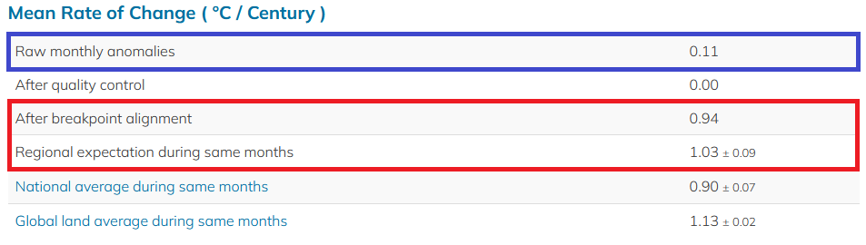
 For an illustration on how Phoenixville has changed over time (Source: Berkeley Earth): These changes mean that simply using raw data across time creates an "apples-to-oranges" comparison when it comes to data integrity. Notice the larger difference in warming trend between the raw data and region and much closer figure between the breakpoint-adjusted data and the region.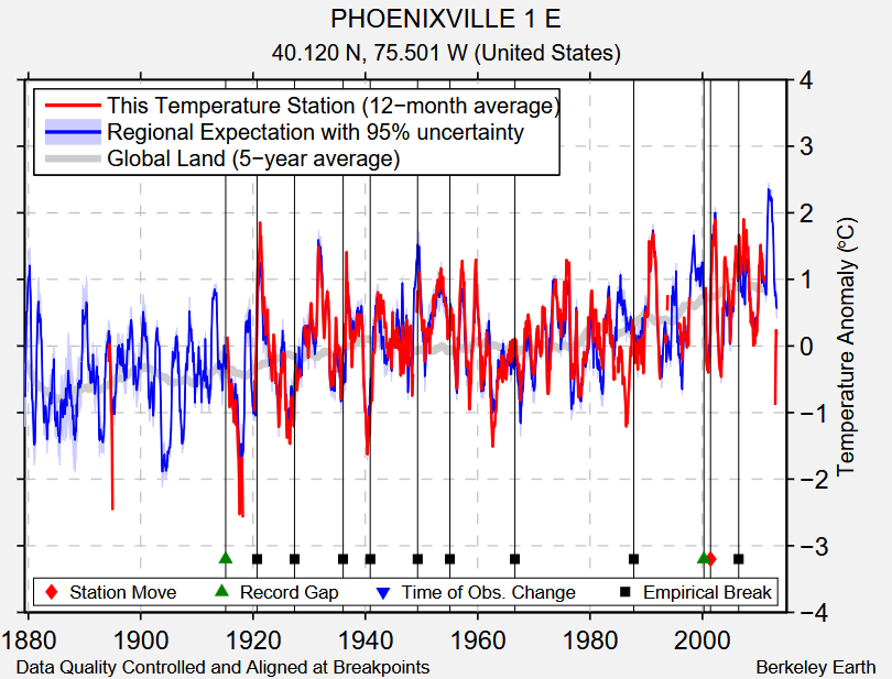
-
"Only" 2.70 so far in Wilson. Looking at the radar, looks unlikely I make it to 3.00", which would be a bit of a disappointment. Still great though. At 4.39" for the week and 6.47" for the month
-
 Yeah probably not a lot of swampazz this summer. Just a lot of 50s and 60s dews from now through Jan.
 -
currently riding this ridge roller being sold by the goofus
-
I picked up 0.42" on Tuesday night about 30 minutes after the start of the dry lightning storm, and 0.80" on Wednesday. Today looks like a repeat of yesterday, so really pleased so far. After today, it looks like a couple of days of limited moisture up here then rain chances go up again Sunday thru most of next week.
-
15-16 incoming...hopefully we get a blizzard during the 3 week winter
-
so much for your epic torch July
-

E PA/NJ/DE Summer 2026 Obs/Discussion
PhiEaglesfan712 replied to PhiEaglesfan712's topic in Philadelphia Region
I think she's retiring. -

E PA/NJ/DE Summer 2026 Obs/Discussion
Mikeymac5306 replied to PhiEaglesfan712's topic in Philadelphia Region
Kinda off topic but I saw Cecily Tynan post she has big personal news to announce at 6PM. Wonder if she is going to ABC News? -
 Yea…any sustained heater is more towards mid-Aug and by then we are on the backside so the bite isn’t as hard anyway.
 -

Spring/Summer 2026 Pattern Discussion Thread
John1122 replied to Carvers Gap's topic in Tennessee Valley
I take that back, it moved from drought 1 to abnormally dry and it didn't count the 1.3 inches of combined rain I got Monday and yesterday, since it was actual measured rain through 8am Monday. -
Spring/Summer 2026 Pattern Discussion Thread
John1122 replied to Carvers Gap's topic in Tennessee Valley
This week's drought monitor didn't really change for my area despite around 3.5 inches of rainfall since it last came out. Surprised by that. Remained abnormally dry. -
Spring/Summer 2026 Pattern Discussion Thread
John1122 replied to Carvers Gap's topic in Tennessee Valley
I only got about .4 yesterday. 15 miles away it was 10x that. After 15 inches in 30 days, I'm kind of glad to have missed it. My yard is out of control and it hasn't been dry a single 24 hour period in seemingly over a week. -
I don't agree with a -PNA winter season.
-

Central PA Summer 2026 Discussion/Obs Thread
mahantango#1 replied to Voyager's topic in Upstate New York/Pennsylvania
NWS State College: So far this year, we have issued more Severe Thunderstorm + Tornado Warnings than any time in our office's history! 238 SVR + TOR warnings year-to-date surpasses 2019 (232) and 1998 (230). We are GRATEFUL for this ongoing stretch of tranquil weather. #PAwx -
2026-2027 Super El Nino
PhiEaglesfan712 replied to Stormchaserchuck1's topic in Weather Forecasting and Discussion
I thought July 2012 broke the record for the warmest month. Or is that still in verification stage? - Today
-
 Also sorry [mention=919]HIPPYVALLEY[/mention] but this winter you going to be the only one back in the valley... Moving up to West Townshend next Month
 -

2026-2027 Super El Nino
LakePaste25 replied to Stormchaserchuck1's topic in Weather Forecasting and Discussion
I was asking about the contours in the rossby wave source map. Assuming those are 200mb ridges and troughs (with the opposite sign). -
Feels like an el nino Christmas in July
-
Certainly going to fully enjoy the next few days!
-
4.30'' here in the last 12 hours or so. Gets me over 10'' for the month.
-
Winter 2026-2027 Speculation
Prismshine Productions replied to 40/70 Benchmark's topic in New England
CFS got an ugly -PNA/-NAO combo Sent from my SM-S176V using Tapatalk -
10/10 day for late July
-
AVP hasn’t had their final 90° occur before this date since 2009. They’ve done 90+ in September in 10 of the last 21 years. Good luck to him though.