All Activity
- Past hour
-
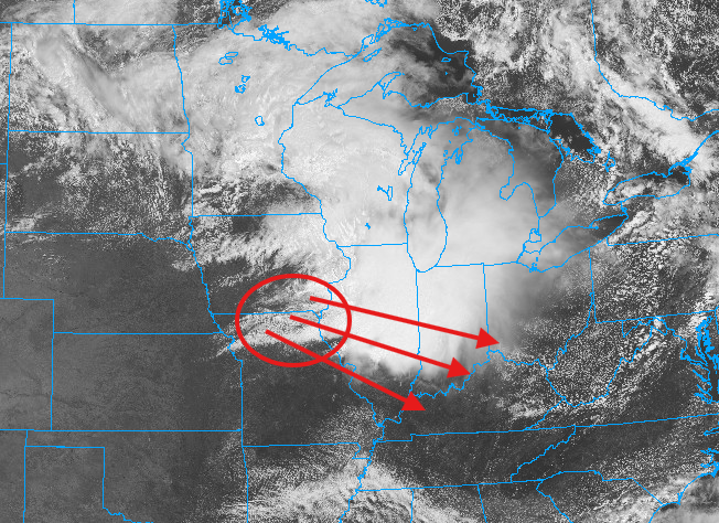
Mesoscale Discussion 1165 NWS Storm Prediction Center Norman OK 0103 PM CDT Wed Jun 17 2026 Areas affected...portions of northern/central Missouri...western Illinois Concerning...Severe potential...Watch likely Valid 171803Z - 172000Z Probability of Watch Issuance...95 percent SUMMARY...Thunderstorm development likely by the afternoon with potential for all hazards including damaging wind, large hail, and strong tornadoes. DISCUSSION...Morning convection has moved into central/eastern Illinois, with trailing outflow and a zone of differential heating extending across northern Missouri into south-central Illinois. This zone will be the focus of redevelopment of thunderstorm activity this afternoon. Strong daytime heating is ongoing across central/northern Missouri into far western Illinois in the cloud free zone south of the outflow. SPC Mesoanalysis indicates that MLCIN is eroding in this region, with temperatures climbing into the mid 80s F. This is further confirmed by visible satellite trends with the cumulus near the vicinity of the outflow also becoming increasingly agitated. Strong deep layer shear around 50-55 kts is analyzed across this region, with STP around 2-3 across northern Missouri into far western Illinois. This in combination with strong to moderate instability edging northward will likely support initial supercells capable of large hail, damaging wind, and tornadoes (perhaps strong). A 40-50 kt low level jet axis extends from the southern/central Plains into Missouri/western Illinois. This is progged to shift north and eastward through the afternoon, which may shift the higher STP and more favorable tornado potential into portions of western/central Illinois. One or more watches will likely be needed to cover this potential this afternoon. ..Thornton/Hart.. 06/17/2026 ...Please see www.spc.noaa.gov for graphic product... ATTN...WFO...LOT...ILX...LSX...DVN...SGF...EAX...TOP... LAT...LON 38788965 39578844 40158794 40518805 40738844 40788904 40599090 40469164 40309251 40129360 40049405 39629469 39309489 38959516 38169511 37979368 38499057 38619015 38788965 MOST PROBABLE PEAK TORNADO INTENSITY...140-170 MPH MOST PROBABLE PEAK WIND GUST...65-80 MPH MOST PROBABLE PEAK HAIL SIZE...2.00-3.50 IN
-

super el nino banter thread
rclab replied to forkyfork's topic in Weather Forecasting and Discussion
Ah come on S19 ….. in our UHI warm ocean hugging coastal plain environment …. At best …. that’ll be a cheap high. As always …. -

E PA/NJ/DE Summer 2026 Obs/Discussion
RedSky replied to PhiEaglesfan712's topic in Philadelphia Region
I received thirty raindrops from shower #1 Hope to at least double that with incoming shower #2! You would think with the major atmosphere reshuffling underway to a super duper El ninnomaxing that the dry pattern would abate -
Just had a very brief moderate shower here. Only 0.02".
-
45-50 along the shore with a Lake breeze, and a steady -RN. Very mid Fallish/mid Springish wx.
-
tiny moisture-starved shower imby
-
A few tiny cells popping up in extreme northeast Maryland
- Today
-
storms building as the shortwave moves in
-
There is a line of rapidly growing towering CU across eastern PA and NW NJ. These will be producing increased coverage of showers/storms shortly.
-
Getting crazy dark to my sw driving into work.
-
If it’s going to be this cold and miserable I don’t want to get gyped on the rainfall.
-
This is just round 1. Round two is going to ignite within this area and we'll see a line of supercells quickly fire up in the next 2-4 hours. Big instability building within this area and will build downstream as the clouds break and temps skyrocket with steepening lapse rates
-
That’s just the first wave. There were legit winds back in Iowa but the afternoon stuff should pop in a few hours.
-
80% of my 2026 total in June. Congrats This recent stretch has alleviated drought concerns locally
-
Storms in the corn belt seem to be busting.
-
You've had more rain today that I have had all month.
-
Typical rainy fall day here
-
Good amount of 2-3” limbs down all over town
-
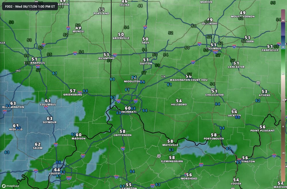
HRRR over-mixing bias on display once again, latest run undershoots dew points by several degrees across my area, with obs in the colored labels. 13z RRFS seems to have a much better handle on moisture, although it's under-doing SBCAPE by 750-1000J/kg, per mesoanalysis
-
-
not this time, that was a real call for a change.
-
Already looking like tomorrow's rain will bust again here. Brutal. This fall will be rough if things don't change.
-
Think it's some process that's enhancing the surface flow. Bringing some of the higher velocity winds down to the surface.
-
My rain total is 2.35". June is 8.37".
-
Wake low?


.thumb.jpg.ad3a2e31d30aff035044689b311a0540.jpg)


