All Activity
- Past hour
-
.thumb.jpg.6a4895b2a43f87359e4e7d04a6fa0d14.jpg)
Central PA Spring 2026 Discussion/Obs Thread
Yardstickgozinya replied to Voyager's topic in Upstate New York/Pennsylvania
I feel like the emi raccoon should be working on my cellphone. That would be a great tool for radar and velocity signature comparison. -
We talk about weathers fraud 5... how about life's? Go to bed early so you can feel extra refreshed in the morning... and wake up feeling like shit. Seems to happen every time! Where's the caffeine!?
-
I learnfrom my vacation tech friend that many forced air systems are installed totally wrong. We spent a day adding returns, and a supply. Made all the difference... and so did removing any air intrusion into the basement and insulating rim joist are and walls above grade. Made a huge difference, and we see it in our gas/electric bills. I think mini splits are cool... but there's no way I'll have one of those indoor units on the walls of multiple rooms
-
23° useless expensive degrees.
-
Central PA Spring 2026 Discussion/Obs Thread
Yardstickgozinya replied to Voyager's topic in Upstate New York/Pennsylvania
@Jns2183 I should have mentioned that I don't have a computer or laptop at the moment. My son and I are building ourselves Pc's for gaming and editing as a father son project, but not for a few more weeks. While playing around with stuff last night I realized that don't have the capabilities to open those files, or use the tools you recommend at the moment. -
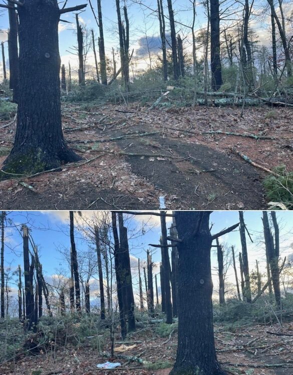
Looks like Montague had a microburst
-
 Updated- Public Information Statement National Weather Service Mount Holly NJ 724 PM EDT Tue Mar 17 2026 ...CONFIRMED EF-1 TORNADO IN CAROLINE COUNTY MARYLAND... ...EXTENSIVE STRAIGHT-LINE WIND DAMAGE CONFIRMED IN QUEEN ANNE'S COUNTY MARYLAND... ...CONFIRMED EF-1 TORNADO IN KENT COUNTY DELAWARE... The survey team from the National Weather Service office has confirmed a tornado occurred Monday evening near Frederica, Delaware (Kent County). The preliminary rating is an EF-1 with estimated maximum wind speed of 100 mph. Additional extensive wind damage near Camden Delaware remains under review. Preliminary estimate of maximum wind speed in this area is 100 mph. A determination if this was straight line wind or tornado damage will be coming later. Previously the survey team had confirmed a tornado occurred Monday evening in Ridgely, Maryland (Caroline County). The preliminary rating of this tornado is an EF-1 with maximum winds to 100 mph. The survey team also examined significant wind damage that occurred between Sudlersville and Millington in Maryland (Queen Anne's County). The preliminary result is that extensive straight- line winds occurred with speeds between 70-90 mph. A final assessment including all of the details are expected to be completed and transmitted via a Public Information Statement on Wednesday.
 - Today
-

E PA/NJ/DE Spring 2026 Obs/Discussion
Voyager replied to PhiEaglesfan712's topic in Philadelphia Region
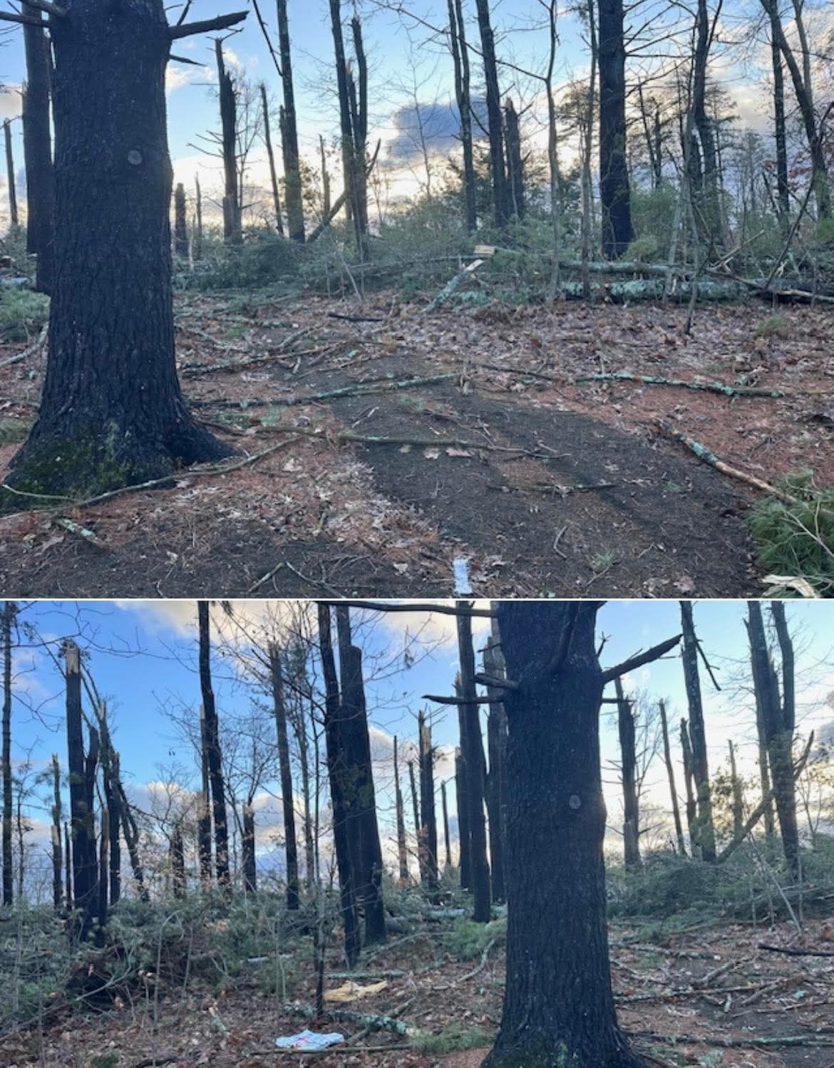
My night shift truck partner had a fear of God moment last night. She was north bound, empty, on 309, just about to the base of the Blue Mountain when all hell broke loose. Blinding rain and wind so strong that she thought our taker truck was going to lay over on its side. She parked and waited. After it passed, she managed to get up over the mountain, but she said it looked like a war zone with trees and wires down up the entire Lehigh County side. End result of that was a 16 hour closure of 309 going over the mountain for clean up and utility repairs. -
28 degrees here
-
0z GFS has the goods! Fri into Sat, 3/27 into 3/28. Eye on the ball people lol
-

2026-2027 El Nino
Stormchaserchuck1 replied to Stormchaserchuck1's topic in Weather Forecasting and Discussion
Here is what a typical El Nino Summer looks like in the 1948-2020 dataset -
I had no idea it was supposed to snow tonight, but we just had a snow shower and now I see the forecast says it will snow some in the morning.
-

Pittsburgh/Western PA WINTER ‘25/‘26
blackngoldrules replied to Burghblizz's topic in Upstate New York/Pennsylvania
Crazy graphic posted by the NWS. A 60 degree day with over 6 inches of snow. Has never happened before. -
2025-2026 ENSO
Stormchaserchuck1 replied to 40/70 Benchmark's topic in Weather Forecasting and Discussion
March SSW's have not coincided with lagging -NAO's the last few times. -

2026-2027 El Nino
so_whats_happening replied to Stormchaserchuck1's topic in Weather Forecasting and Discussion
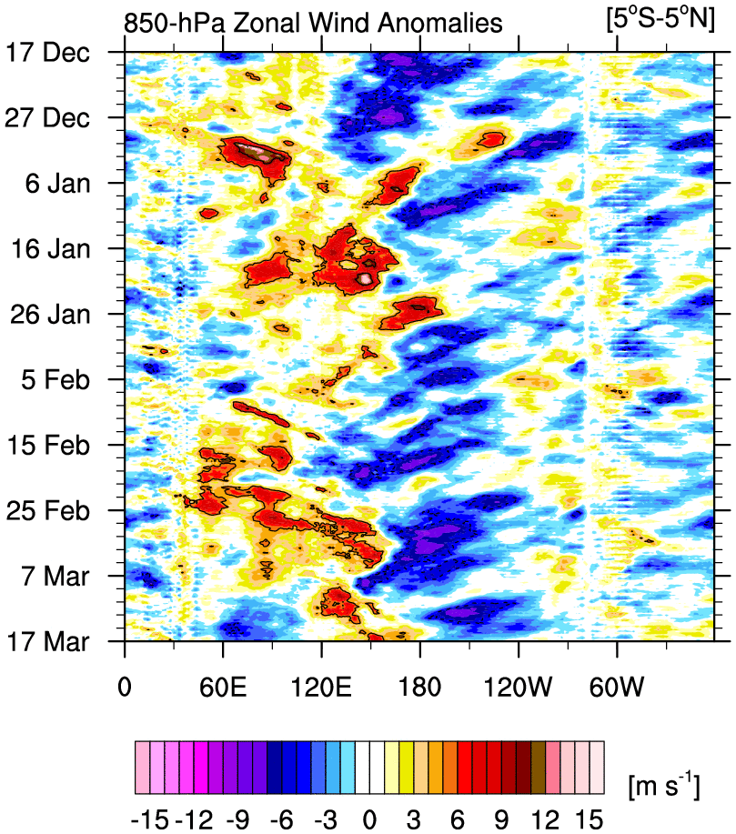
I see the potential but I just can't shake that this doesn't quite get to those levels. Now that things are starting to shine some light on the potential of at least an El Nino im happy to take my weak stance to a moderate level coming up here for the summer and fall with a chance to strong. Super is a stretch for now but also have to see how things progress past the spring barrier. I know I have shared this countless times in comparison and of course not all Nino's will form the same way but I can't help but notice that this setup is different in approach than the 23-24 season with westerly anomalies not as strong in the eastern Pac. I think this has role in maybe limiting the potential of how strong it can get and potentially placement as well but again plenty of time to watch things unfold. I only have what I have saved so forgive me when they dont show a similar time period. Also notice the lack of a full rotation like we saw in the 2023 example (upper image), maybe this is still to come?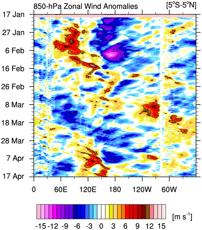

-
2025-2026 ENSO
Stormchaserchuck1 replied to 40/70 Benchmark's topic in Weather Forecasting and Discussion
^ Current NWS forecast for Flagstaff Thursday Sunny, with a high near 83. Friday Sunny, with a high near 85. Saturday Sunny, with a high near 81. -
Advisory is like 2-5" right? I feel like that's a light event. Am I playing by CNE/NNE rules? Lol. That December storm was solid but a 7" storm in late December in this day and age isn't really going to turn any heads. You're closer to the coast so maybe to you it's classified differently.
-

E PA/NJ/DE Spring 2026 Obs/Discussion
RedSky replied to PhiEaglesfan712's topic in Philadelphia Region
This never happens in the winter cold season. No leafs on the trees is a great mitigator of tree damage. -
A tornado watch up the east coast for severe tornadoes and we got one EF-0 tornado of 85 MPH north of Charlotte, NC.
-

E PA/NJ/DE Spring 2026 Obs/Discussion
LVblizzard replied to PhiEaglesfan712's topic in Philadelphia Region
At least you have an estimate. The neighborhood half a mile from me still doesn’t know when it might come back on. There’s a state route that runs through there which is still closed due to wires being down. -
100%. There is a group rooting for this which is beyond me. It’s time for spring
-
So sorry to read this. May God watch over his family and I pray for his family.
-
I get his point though. It’s a subjective combination of multiple factors. Losing a month has to negatively impact the overall score.
-
Typical March. But, the on the plus side, this is April in New England
-
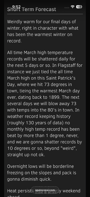
Here’s a snippet from today’s Arizona daily snow on opensnow. I hope this is ok to share here. More remarkable extreme warmth in the West.