All Activity
- Past hour
-
Really feels like no one knows what will happen with regards to winter storms here until we are 24 hours out or less. First it was we weren't going to have enough precip and temps weren't an issue to now temps are going to be too warm. The GFS and NAM have been all over the place. It's sad that the NAM goes from 6 inches here to nothing in one run just 48 hours out. They need to figure out something with these models because it seems the algorithms they use now don't match our climate data or something anymore because they shouldn't be that bad. It feels like the Euro is the only one that is worth looking at to see if there is going to be a chance of snow and then maybe the short range models like the HRRR inside 24 hours for totals.
-

January 2026 Medium/Long Range Discussion
nw baltimore wx replied to snowfan's topic in Mid Atlantic

-

January 2026 regional war/obs/disco thread
qg_omega replied to Baroclinic Zone's topic in New England
that was classic remember that like it was yesterday -

January 2026 regional war/obs/disco thread
WeatherGeek2025 replied to Baroclinic Zone's topic in New England
reggie? -

January 2026 regional war/obs/disco thread
Typhoon Tip replied to Baroclinic Zone's topic in New England
oh must be the 06z gfs fantasy. m'yeah i'd table that whole thing actually. i prefer when in times of unusually high uncertainty to avoid the consensus passively denying CC is fucking everything up and making it be that way ... by relying on index modes and modalities. they like the 28th - ground hog day -ish. there's some signal there re the this 24/25th but not as much, so that's why i table for now. -
It was 13° this morning when I left my house at 5:15. I’m not sure if it went any lower or not. The clouds moved in so it may not have. We’re on the way to Banff and Lake Louise to ski and board this weekend. Currently in Chicago, where there’s probably 1-1.5in on the ground and the unused roads and runways are covered here. Anyways, I’ll be pulling for everyone to score tonight!
-

January 2026 Short/Medium Range Thread
Holston_River_Rambler replied to John1122's topic in Tennessee Valley
Rediscovered a neat site when going through our links to see if I could find the site that shows how aircraft observations differed from model initialization conditions. I'm going to keep looking for that, but in the meantime, check the meridional flow into AK: (this is a precipitable water layer) Link: https://re.ssec.wisc.edu/?products=MIMICTPW2.100¢er=11.178401873711785,-157.14843750000003&zoom=2&width=1316&height=780&basemap=bluemarble&labels=line&view=leaflet&timeproduct=MIMICTPW2×pan=-24t&animationspeed=100&animate=true A little bit of a learning curve to use, but it has a lot of views of the earth and atmosphere. -

2025-2026 Fall/Winter Mountain Thread
Maggie Valley Steve replied to Buckethead's topic in Southeastern States
I don't know folks. The 12Z 3km NAM sure is keying in on the Balsams and Cataloochee Mountains overnight. That model suggests 6 to 8 inches around here. Cut the totals in half and it's still 3 to 4 inches..thumb.png.105ebbd56b076f6d98b7aecec5648858.png)
-

January 2026 regional war/obs/disco thread
40/70 Benchmark replied to Baroclinic Zone's topic in New England
I honestly think I am out of here when my family upgrades in a a few to several years...the difference in latitude from here to Boston northern suburbs is absolutely inimical to snowfall. I honestly mean this....it's not frustration talking. You don't benefit from latitude on the CP until into se NE, but you still miss out on some SNE events. -

Occasional Thoughts on Climate Change
WolfStock1 replied to donsutherland1's topic in Climate Change
In general the policy shift hasn't been "anti-renewable" though - it's been towards weaning renewables off the government tit to self-sustaining mode. The cancellations have been when people and companies find that many of these projects are not actually financially viable. However that said - of note is that this started happening in late 2023 - long before the current administration came in and started implementing its policy shift. As such much of the failures of these projects had nothing to with policy - but rather a slow popping of the post-covid renewable energy bubble. -
I saw a video of the snow squall but didn’t see the wreck. My goodness that’s right up there with one of the worst! You’d expect that if there was a ton of snow or ice but sometimes the smallest amount of ice sneaks up on you. Wow!
-
January 2026 regional war/obs/disco thread
Typhoon Tip replied to Baroclinic Zone's topic in New England
day 9/10 ...which one is that, off of which run cycle... this stuff is all f'n buckshot right now -
Nam replacement
.thumb.png.56df23975faab765b84dcfaccb94e3f7.png)
-

2025-2026 ENSO
donsutherland1 replied to 40/70 Benchmark's topic in Weather Forecasting and Discussion
My confidence that we are in the early stages of what will be a regime change to a predominantly positive PNA since the end of the PNA- regime on January 11th has increased. The latest guidance shows most of the days will be positive through at least January 26. The regime change is consistent with historic experience following 25-day or longer PNA- regimes during winter.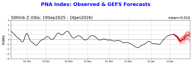
-

Another Coating of Snow Saturday - "It's all we Got"
metagraphica replied to Sey-Mour Snow's topic in New England
Looking forward to my 0.14" of rain. -
Thanks, Brick. Even that’s probably overdone in much of the blue area (1”+) due to marginal temps. But that blue area on your 12Z map an hour or so to my west is my tentative target for a Sun PM drive.
-

First Legit Storm Potential of the Season Upon Us
TauntonBlizzard2013 replied to 40/70 Benchmark's topic in New England
A decade ago, this would be an easy trend in to 8-12” region wide. My guess is this ends up out to sea. We’ve seen this exact pattern play out already like 3 times this year. Threat looks awful at day 4. Subtle trends back the next few cycles, and then the rug pull and it spends the final 48 hours ticking east -
I’m not nearly as knowledgeable as most people here on MJO stuff but the look at the end of the ensembles does not look like a phase 8 or even 7 for that matter to me. It almost looks like it’s moving to something you’d see in 6.
-
Gotta love the 1994 event summary. Frigid air over eastern Canada just continued to push and funnel straight south over snow covered ground. Met up with moisture from the south and snow and ice events were plentiful. Thing I remember most is the frozen solid ruts of snow and ice on the roads for days at a time. With snow, sleet and freezing rain the road crews could not properly clear the roads and everything just froze solid. Was like driving on an obstacle course.
-
Check out the other mesoscale models for tomorrow- it’s not the only one.
-
NAM went from this To this in one run.
-
really ?
-

First Legit Storm Potential of the Season Upon Us
CoastalWx replied to 40/70 Benchmark's topic in New England
You’ll be fine. Should get some tomorrow. -
I'll keep hugging the HRRR and RGEM. Then when nothing happens, I'll rant about what horrible models they are. Chilly Jebwalk this morning, 23F.
-

First Legit Storm Potential of the Season Upon Us
HoarfrostHubb replied to 40/70 Benchmark's topic in New England
I'm ready for that


.png.b928356fbb7e6e11e7d4fd96f5929150.png)

.png.4e9fdb364d6efdc0dd1009fda2b4f830.png)


